Latitude/Longitude Disclaimer: The gauge location shown in the above map
is the approximate location based on the latitude/longitude coordinates
provided to the NWS by the gauge owner.
Flood Impacts & Photos
If you notice any errors in the below information, please contact our Webmaster
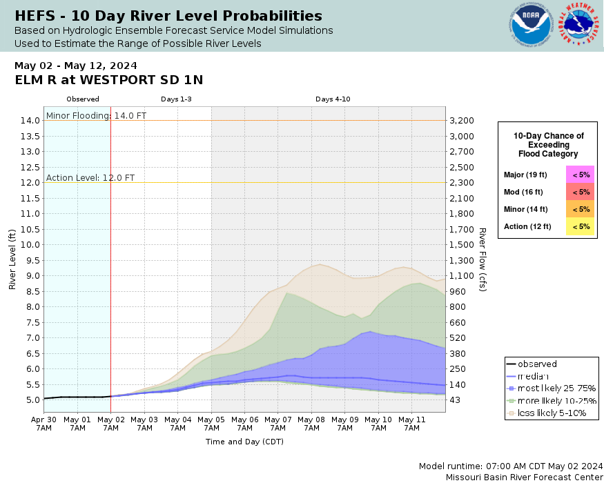
22.5
The bridge 2 miles south and 1 mile east of Westport will be overtopped
22
Large portions of Westport will have water 2 to 3 feet deep
21
The bridge on Brown County Road 10a is overtopped
20.5
The water will reach the bottom of the bridge 2 miles south and 1 mile east of Westport. The bridge east of Westport will be overtopped
19
The community of Westport begins to flood
18.5
The water will reach the bottom of the bridge east of Westport
17.5
Water reaches the bottom of the bridge north of Westport
16
Several gravel roads along the river begin to flood
14.5
The bridge northwest of Kruse Dam will be overtopped
14
The county road east of Westport becomes impassable
12.5
The water will reach the bottom of the bridge north of Kruse Dam
The National Weather Service prepares its forecasts and other services in collaboration with agencies like the US Geological Survey, US Bureau of Reclamation, US Army Corps of Engineers, Natural Resource Conservation Service, National Park Service, ALERT Users Group, Bureau of Indian Affairs, and many state and local emergency managers across the country. For details, please click here.
NWS Information
National Weather Service
Aberdeen Weather Forecast Office
824 Brown County 14 South
Aberdeen, SD 57401 Ask Questions/Webmaster
Page last modified: 2-Nov-2020 7:29 PM


