Skip Navigation Link weather.gov  
NOAA logo - Click to go to the NOAA homepage National Weather Service NWS logo - Click to go to the NWS homepage
Advanced Hydrologic Prediction Service
Image background of Navigation bar Left
Navigation Bar End Cap


This probabilistic forecast is issued by the Northeast River Forecast Center.
tab left off Hydrograph tab right off tab left off River at a Glance tab right off tab left off Download tab right off tab left on tab right on
About this graph
Forecasts for the Esopus Creek at Ashokan Reservoir East are issued routinely year-round.
Return to Area Map

Upstream Gauge - at Cold Brook Upstream Gauge Downstream Gauge Downstream Gauge - at Mount Marion
Zoom Level:16
Flood Categories (in feet)
Major Flood Stage: 591
Moderate Flood Stage: 590
Flood Stage: 589
Action Stage: 587.1
Low Stage (in feet): -9999

Historic Crests
(1) 592.23 ft on 03/31/1951
(2) 591.38 ft on 04/03/2005
(3) 590.90 ft on 04/05/1987
(4) 590.58 ft on 08/29/2011
(5) 589.92 ft on 04/17/2007
Show More Historic Crests

(P): Preliminary values subject to further review.

Recent Crests
(1) 589.56 ft on 09/08/2011
(2) 590.58 ft on 08/29/2011
(3) 589.39 ft on 03/23/2010
(4) 589.92 ft on 04/17/2007
(5) 591.38 ft on 04/03/2005
Show More Recent Crests

(P): Preliminary values subject to further review.

Low Water Records
(1) 525.91 ft on 10/24/1926
(2) 532.64 ft on 02/20/1981
(3) 536.86 ft on 10/09/1985
(4) 539.28 ft on 04/12/1989
(5) 540.91 ft on 12/21/1993
Show More Low Water Records
KML Image
Gauge LocationGauge Map Marker
Disclaimer
Latitude/Longitude Disclaimer: The gauge location shown in the above map is the approximate location based on the latitude/longitude coordinates provided to the NWS by the gauge owner.
Flood Impacts & Photos Collapse
If you notice any errors in the below information, please contact our Webmaster
587.1 Reservoir at spillway level and begins to overflow into the Esopus Creek downstream. Downstream flooding is reference to the Mount Marion gage MRNN6.
586.5 This basin is nearly full and only 0.25 inch runoff is needed to start spilling over into the Esopus Creek downstream.
585.79 This basin has capacity for only about 0.50 inch of runoff before it will overflow into the Esopus Creek downstream.
585.1 This basin has capacity for only about 0.75 inch of runoff. It is getting close to full.
584.4 This basin has capacity for only about 1.0 inch of runoff.
583.1 This basin has capacity for about 1.5 inches of runoff.
581.6 This basin has capacity for about 2.0 inches of runoff.
580.29 This basin has capacity for about 2.5 inches of runoff.
578.79 This basin has capacity for about 3.0 inches of runoff.
576 This basin has capacity for about 4.0 inches of runoff.
573 This basin has capacity for about 5.0 inches of runoff.
570 This basin has capacity for about 6.0 inches of runoff.
Additional Information Collapse
Potential River Levels - Used to
Potential River Levels
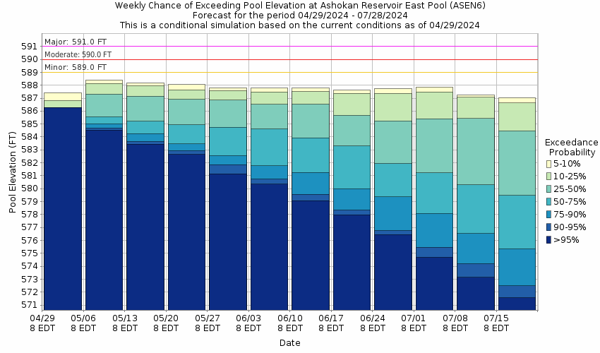
Used to Estimate the Chance of Flooding and the Range of Possible River Levels
10 Day (HEFS) 7 Day (NAEFS) 7 Day (GEFS)
HEFS Ensemble NAEFS Ensemble GEFS Ensemble

Note: Use the official hydrograph at the top of this web page for river levels within the next 72 hours.

Click individual graphics to enlarge.

Collaborative Agencies Collapse
The National Weather Service prepares its forecasts and other services in collaboration with agencies like the US Geological Survey, US Bureau of Reclamation, US Army Corps of Engineers, Natural Resource Conservation Service, National Park Service, ALERT Users Group, Bureau of Indian Affairs, and many state and local emergency managers across the country. For details, please click here.
NWS Information
National Weather Service
Albany Weather Forecast Office
ETEC - 1400 Washington Avenue
Albany, NY 12222
(518) 626-7570
Ask Questions/Webmaster
Page last modified: 2-Nov-2020 7:30 PM
Disclaimer
Credits
Glossary
Privacy Policy
About Us
Career Opportunities