Skip Navigation Link weather.gov  
NOAA logo - Click to go to the NOAA homepage National Weather Service NWS logo - Click to go to the NWS homepage
Advanced Hydrologic Prediction Service
Image background of Navigation bar Left
Navigation Bar End Cap


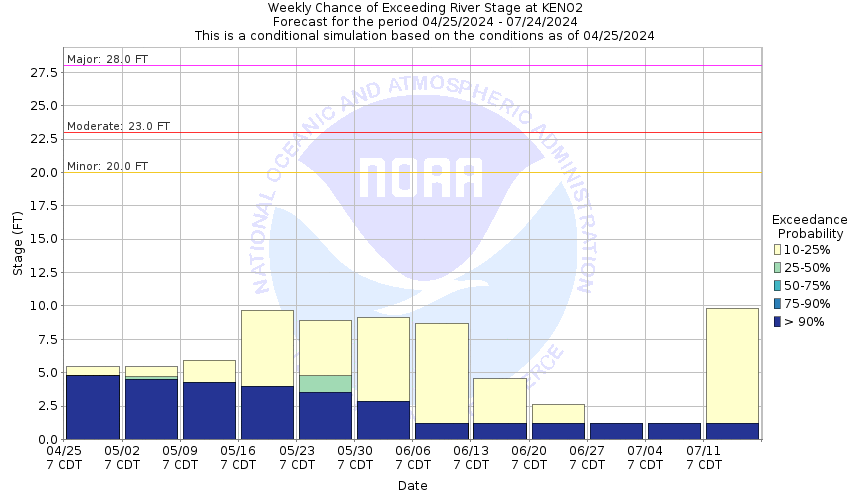
This probabilistic forecast is issued by the Arkansas Red-Basin River Forecast Center.
tab left off Hydrograph tab right off tab left off River at a Glance tab right off tab left off Download tab right off tab left on tab right on
About this graph
Forecasts for the Cimarron River (OK) at Kenton are issued as needed during times of high water, but are not routinely available.
Return to Area Map

Zoom Level:16
Flood Categories (in feet)
Major Flood Stage: 28
Moderate Flood Stage: 23
Flood Stage: 20
Action Stage: 11
Low Stage (in feet): -9999

Historic Crests
(1) 22.32 ft on 10/17/1965
(2) 22.31 ft on 07/30/2017
(3) 21.62 ft on 06/25/1977
(4) 21.47 ft on 08/04/2013
(5) 20.74 ft on 06/05/1978
Show More Historic Crests

(P): Preliminary values subject to further review.

Recent Crests
(1) 11.74 ft on 05/31/2021
(2) 14.39 ft on 07/31/2017
(3) 22.31 ft on 07/30/2017
(4) 17.26 ft on 07/30/2014
(5) 17.56 ft on 07/15/2014
Show More Recent Crests

(P): Preliminary values subject to further review.

Low Water Records
(1) 5.20 ft on 11/01/1965
(2) 5.45 ft on 08/01/1993
KML Image
Gauge LocationGauge Map Marker
Disclaimer
Latitude/Longitude Disclaimer: The gauge location shown in the above map is the approximate location based on the latitude/longitude coordinates provided to the NWS by the gauge owner.
Flood Impacts & Photos Collapse
If you notice any errors in the below information, please contact our Webmaster
28 Several miles of ranch land flood. County road, just northeast of Kenton inundated. Several homes may flood. Northwest corner of the Kenton community is threatened by floodwaters.
23 Approaches to the bridge on the county highway, 2 miles northeast of Kenton may become impassable. Several residents likely cutoff. Thousands of acres of ranch land flood with cattle losses possible.
20 Significant ranch land flooding occurs. Damage to fences likely. Flooding along the north carrizo creek will enhance flooding at its confluence, two miles downstream from the gage site. Secondary roads may flood downstream and isolate residents. Several low water crossings in along the river are inundated and impassable.
11 Bankfull stage. Water is up to the lowest natural banks but within secondary banks. Low water crossings upstream and downstream are likely flooded. Fences below the secondary bank could sustain damage. No other known threats.
Photos
(1) Looking upstream
(2) Looking downstream

Other Real-time and/or Archive Data Sources:

Collaborative Agencies Collapse
The National Weather Service prepares its forecasts and other services in collaboration with agencies like the US Geological Survey, US Bureau of Reclamation, US Army Corps of Engineers, Natural Resource Conservation Service, National Park Service, ALERT Users Group, Bureau of Indian Affairs, and many state and local emergency managers across the country. For details, please click here.
NWS Information
National Weather Service
Amarillo Weather Forecast Office
1900 English Road
Amarillo, TX 79108
Ask Questions/Webmaster
Page last modified: 2-Nov-2020 7:29 PM
Disclaimer
Credits
Glossary
Privacy Policy
About Us
Career Opportunities