Skip Navigation Link weather.gov  
NOAA logo - Click to go to the NOAA homepage National Weather Service NWS logo - Click to go to the NWS homepage
Advanced Hydrologic Prediction Service
Image background of Navigation bar Left
Navigation Bar End Cap


This probabilistic forecast is issued by the Middle Atlantic River Forecast Center.
tab left off Hydrograph tab right off tab left off River at a Glance tab right off tab left off Download tab right off tab left on tab right on
About this graph
Forecasts for the Neversink River at Godeffroy are issued routinely year-round.
Return to Area Map

Upstream Gauge - at Bridgeville Upstream Gauge
Zoom Level:14
Flood Categories (in feet)
Major Flood Stage: 12
Moderate Flood Stage: 11
Flood Stage: 10
Action Stage: 8
Low Stage (in feet): -9999

Historic Crests
(1) 12.49 ft on 08/19/1955
(2) 12.40 ft on 04/03/2005
(3) 12.05 ft on 08/28/2011
(4) 11.79 ft on 11/26/1950
(5) 11.57 ft on 01/24/2018
Show More Historic Crests

(P): Preliminary values subject to further review.

Recent Crests
(1) 11.57 ft on 01/24/2018
(2) 12.05 ft on 08/28/2011
(3) 10.89 ft on 04/16/2007
(4) 11.08 ft on 06/28/2006
(5) 12.40 ft on 04/03/2005
Show More Recent Crests

(P): Preliminary values subject to further review.

Low Water Records
Currently none available.
KML Image
Gauge LocationGauge Map Marker
Disclaimer
Latitude/Longitude Disclaimer: The gauge location shown in the above map is the approximate location based on the latitude/longitude coordinates provided to the NWS by the gauge owner.
Flood Impacts & Photos Collapse
If you notice any errors in the below information, please contact our Webmaster
12.49 Flood of record from Hurricanes Connie and Diane on August 19, 1955.
12.4 Flood of April 3, 2005. Large scale inundation of Meyers Grove, the lower half of Butler Lane Mobile Home Park, the Hospital parking lot in Port Jervis, St. Mary's Cemetery, and residences along Riverside Drive. The Port Jervis fire training facility, and lower portions of Guymard Turnpike are flooded.
12 Major flood stage. Water 1 to 2 feet deep alongside homes in meyers grove both along Shore Drive And Avenue e.
11.5 Homes begin to flood on their first floor level along Shore Drive. Streamside cabins at American Family Campground begin to flood. Homes along Rivers Edge Road are threatened.
11 Moderate flood stage. The east side of American Family campground in Godeffroy inundated. Water covers portions of Shore Drive in Godeffroy closest to the river.
10 Minor flood stage. Water locally exceeds the main channel banks near Meyers Grove in the Town of Deerpark.
8 Action stage. Water backs up and fills normally dry river channels on the north side of Meyers Grove area of the Town of Deerpark. Two mobile homes threatened.

Other Real-time and/or Archive Data Sources:

Additional Information Collapse
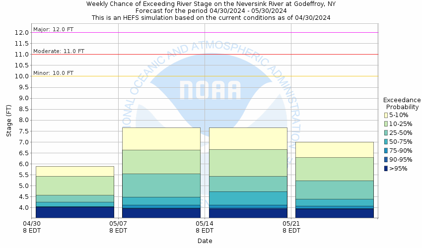
Potential River Levels - Used to
Potential River Levels
Used to Estimate the Chance of Flooding and the Range of Possible River Levels
10 Day (HEFS) 7 Day (NAEFS) 7 Day (GEFS)
HEFS Ensemble NAEFS Ensemble GEFS Ensemble

Note: Use the official hydrograph at the top of this web page for river levels within the next 72 Hours.

Click individual graphics to enlarge.

Collaborative Agencies Collapse
The National Weather Service prepares its forecasts and other services in collaboration with agencies like the US Geological Survey, US Bureau of Reclamation, US Army Corps of Engineers, Natural Resource Conservation Service, National Park Service, ALERT Users Group, Bureau of Indian Affairs, and many state and local emergency managers across the country. For details, please click here.
NWS Information
National Weather Service
Binghamton Weather Forecast Office
32 Dawes Drive
Johnson City, NY 13790
(607) 729-1597
Ask Questions/Webmaster
Page last modified: 2-Nov-2020 7:30 PM
Disclaimer
Credits
Glossary
Privacy Policy
About Us
Career Opportunities