Skip Navigation Link weather.gov  
NOAA logo - Click to go to the NOAA homepage National Weather Service NWS logo - Click to go to the NWS homepage
Advanced Hydrologic Prediction Service
Image background of Navigation bar Left
Navigation Bar End Cap


This probabilistic forecast is issued by the Middle Atlantic River Forecast Center.
tab left off Hydrograph tab right off tab left off River at a Glance tab right off tab left off Download tab right off tab left off Inundation
Mapping
tab right off tab left on tab right on
About this graph
Forecasts for the Chemung River at Corning are issued routinely year-round.
Return to Area Map

Downstream Gauge Downstream Gauge - at Elmira
Zoom Level:16
Flood Categories (in feet)
Major Flood Stage: 36
Moderate Flood Stage: 30
Flood Stage: 29
Action Stage: 21
Low Stage (in feet): -9999

Historic Crests
(1) 40.71 ft on 06/23/1972
(2) 37.74 ft on 05/28/1946
(3) 33.49 ft on 07/07/1935
(4) 33.44 ft on 04/01/1940
(5) 33.34 ft on 07/01/1889
Show More Historic Crests

(P): Preliminary values subject to further review.

Recent Crests
(1) 32.52 ft on 09/26/1975
(2) 40.71 ft on 06/23/1972
(3) 30.34 ft on 03/05/1964
(4) 29.34 ft on 03/07/1956
(5) 30.84 ft on 10/15/1955
Show More Recent Crests

(P): Preliminary values subject to further review.

Low Water Records
Currently none available.
KML Image
Gauge LocationGauge Map Marker
Disclaimer
Latitude/Longitude Disclaimer: The gauge location shown in the above map is the approximate location based on the latitude/longitude coordinates provided to the NWS by the gauge owner.
Flood Impacts & Photos Collapse
If you notice any errors in the below information, please contact our Webmaster
40.7 This stage is the flood of record caused by Hurricane Agnes in 1972.
39 This is the top of the flood protection levees in Corning.
36 Severe flooding begins in Corning. In the past the village of Painted Post and the Corning Glass were evacuated.
34 Backwater begins to effect gage readings. In the past the flood waters reached the bottom of the railroad bridge.
33 Backwater begins to flood Hodgeman Creek.
32 This is the Major flood stage.
30 Moderate Flood Stage. Extensive flooding begins in farmland areas. In the past Route 17E was closed.
29 Minor Flood Stage. Flooding begins in areas unprotected by levees. The City of Corning is protected by levees to 39 feet.
Photos
(1) looking upstream
(2) view of gagehouse
(3) looking downstream

Other Real-time and/or Archive Data Sources:

Additional Information Collapse
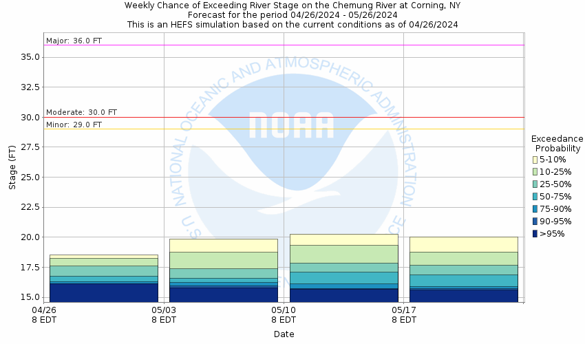
Potential River Levels - Used to
Potential River Levels
Used to Estimate the Chance of Flooding and the Range of Possible River Levels
10 Day (HEFS) 7 Day (NAEFS) 7 Day (GEFS)
HEFS Ensemble NAEFS Ensemble GEFS Ensemble

Note: Use the official hydrograph at the top of this web page for river levels within the next 72 hours.

Click individual graphics to enlarge.

Collaborative Agencies Collapse
The National Weather Service prepares its forecasts and other services in collaboration with agencies like the US Geological Survey, US Bureau of Reclamation, US Army Corps of Engineers, Natural Resource Conservation Service, National Park Service, ALERT Users Group, Bureau of Indian Affairs, and many state and local emergency managers across the country. For details, please click here.
NWS Information
National Weather Service
Binghamton Weather Forecast Office
32 Dawes Drive
Johnson City, NY 13790
(607) 729-1597
Ask Questions/Webmaster
Page last modified: 2-Nov-2020 7:30 PM
Disclaimer
Credits
Glossary
Privacy Policy
About Us
Career Opportunities