Historic Crests
(1) 20.79 ft on 03/31/2010
(2) 15.11 ft on 12/19/2023
(3) 14.98 ft on 03/15/2010
(4) 14.50 ft on 06/07/1982
(5) 14.13 ft on 01/11/2024 Show More Historic Crests
(P): Preliminary values subject to further review.
Recent Crests
(1) 9.72 ft on 03/29/2024
(2) 10.61 ft on 03/24/2024
(3) 11.03 ft on 03/10/2024
(4) 9.69 ft on 03/07/2024
(5) 14.13 ft on 01/11/2024 Show More Recent Crests
(P): Preliminary values subject to further review.
Latitude/Longitude Disclaimer: The gauge location shown in the above map
is the approximate location based on the latitude/longitude coordinates
provided to the NWS by the gauge owner.
Flood Impacts & Photos
If you notice any errors in the below information, please contact our Webmaster
22
This is a serious and potentially life threatening flood situation, nearing or exceeding flood levels seen during the historic March 2010 Floods. Follow the directions of local officials if you are asked to evacuate. Do not go sightseeing and stay away from river banks, which can suddenly give way due to erosion and fast moving water. Swiftly moving water can pose an imminent threat to life. Evacuations are likely in Warwick, West Warwick and Cranston. Homes and businesses will be impacted.
20
This is a serious and potentially life threatening flood situation, approaching flood levels seen during the historic March 2010 Floods. Follow the directions of local officials if you are asked to evacuate. Do not go sightseeing and stay away from river banks, which can suddenly give way due to erosion and fast moving water. Swiftly moving water can pose an imminent threat to life. Evacuations are likely in Warwick, West Warwick and Cranston. Homes and businesses will be impacted.
18
This is a serious and potentially life threatening flood situation. Follow the directions of local officials if you are asked to evacuate. Do not go sightseeing and stay away from river banks, which can suddenly give way due to erosion and fast moving water. Swiftly moving water can pose an imminent threat to life. Evacuations are likely in Warwick, West Warwick and Cranston. Homes and businesses will be impacted.
16.5
This is a serious and potentially life threatening flood situation. Follow the directions of local officials if you are asked to evacuate. Do not go sightseeing and stay away from river banks, which can suddenly give way due to erosion and fast moving water. Swiftly moving water can pose an imminent threat to life. Evacuations are likely in Warwick, West Warwick and Cranston. Homes and businesses will be impacted.
14.5
Evacuations are likely near the Pawtuxet river in Warwick and Cranston. Both homes and businesses will be impacted from this flood event. Businesses and homes will be impacted on streets including but not limited to the following, in Warwick, Pioneer Avenue, Bellows Street, Venturi Avenue and River Street. In Cranston, Wellington Avenue and Avery Road. In West Warwick, Daisy Street, the lower ends of Canna, Begonia and Aster Streets, and portions of Providence Street to Route 2.
12
Evacuations are likely near the Pawtuxet River in Warwick and Cranston. Both homes and businesses will be impacted from this flood event. Businesses and homes will be impacted on streets including but not limited to the following, in Warwick, Pioneer Avenue, Bellows Street, Venturi Avenue, and River Street. In Cranston, Wellington Avenue and Avery Road. In West Warwick, Daisy Street, the lower ends of Canna, Begonia and Aster Streets, and portions of Providence Street to Route 2.
11.5
Homes and businesses are impacted in low lying sections of Warwick, West Warwick and Cranston. Affected roads in Cranston include Avery Road and Wellington Avenue. Affected roads in Warwick include Pioneer Avenue, River Street, Bellows Street and Venturi Avenue. In West Warwick, affected areas include Daisy Street and the lower ends of Canna, Begonia and Aster Streets.
11
Structures and homes are impacted in low lying sections of Warwick. Affected areas include homes and businesses on Wellington Avenue and Avery Road in Cranston, as well as Pioneer Avenue, Bellows Street, Venturi Avenue and a portion of River Street in Warwick.
10
Flooding will occur along Pioneer Avenue, Bellows Street and Venturi Avenue in Warwick. Some homes are impacted on Avery Road and Wellington Avenue in Cranston.
9.5
Parking lots and roads are flooded in low lying areas of Warwick and Cranston near the Pawtuxet River. Impacted roads include River Street, Pioneer Avenue, Bellows Street and Venturi Avenue in Warwick.
9
Minor lowland flooding will occur along the river as it flows through Warwick and Cranston.
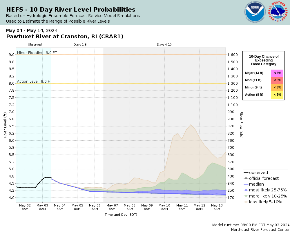
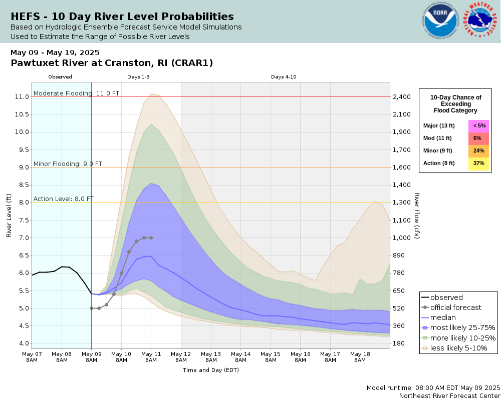
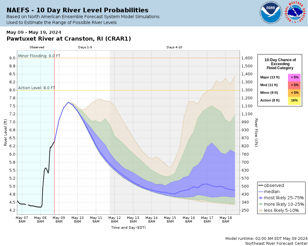
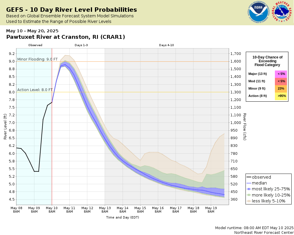
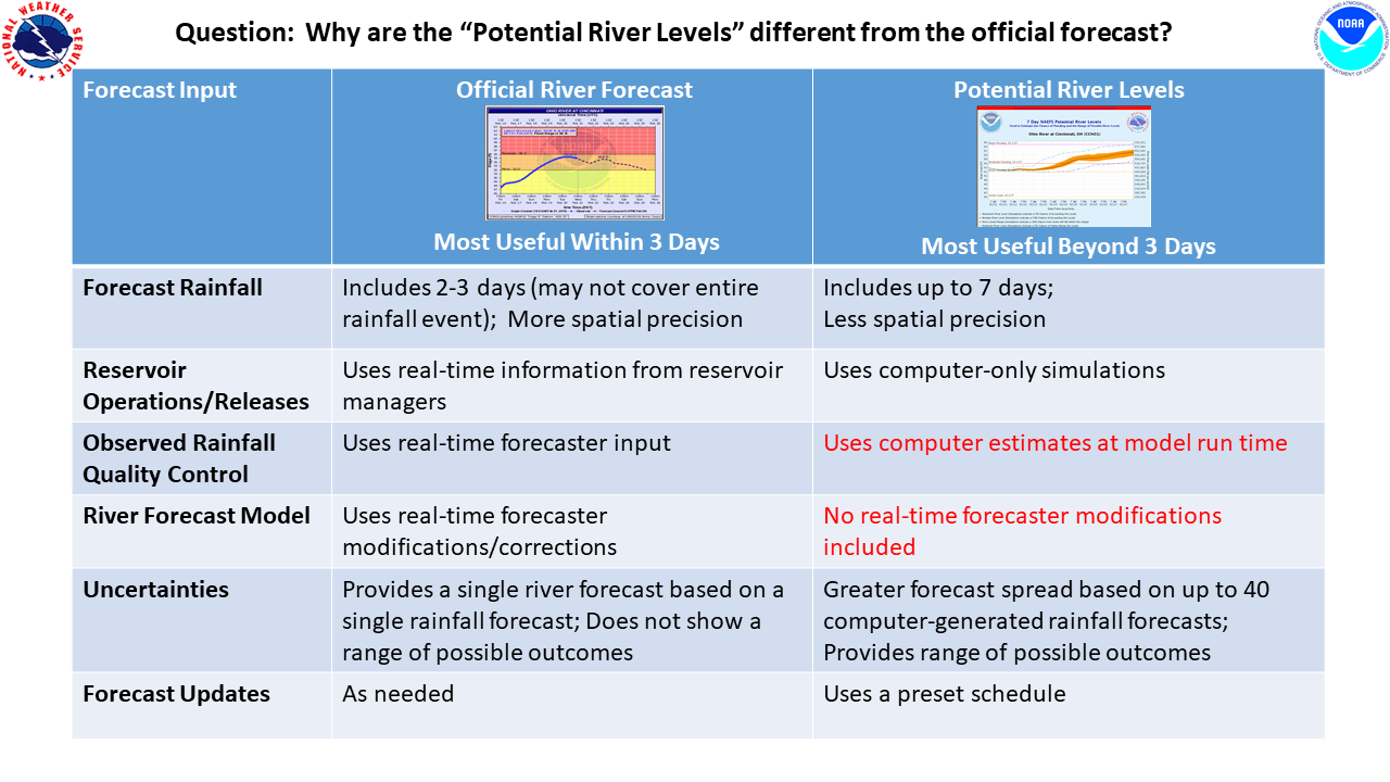
For an explanation of Potential River Levels, see this Fact Sheet.
Potential River Levels - Used to
Potential River Levels Used to Estimate the Chance of Flooding and
the Range of Possible River Levels
10 Day (HEFS)
7 Day (NAEFS)
7 Day (GEFS)
Note: Use the official hydrograph at the top of this web page
for river levels within the next 72 hours.
Click individual graphics to
enlarge.
Collaborative Agencies
The National Weather Service prepares its forecasts and other services in collaboration with agencies like the US Geological Survey, US Bureau of Reclamation, US Army Corps of Engineers, Natural Resource Conservation Service, National Park Service, ALERT Users Group, Bureau of Indian Affairs, and many state and local emergency managers across the country. For details, please click here.
NWS Information
National Weather Service
Boston / Norton Weather Forecast Office
46 Commerce Way
Norton, MA 02766
(508) 622-3250 Ask Questions/Webmaster
Page last modified: 2-Nov-2020 7:30 PM


