Forecasts for the Merrimack River at Lawrence are issued as needed during times of high water, but are not routinely available.Vertical datum height surveyed by the USGS
Latitude/Longitude Disclaimer: The gauge location shown in the above map
is the approximate location based on the latitude/longitude coordinates
provided to the NWS by the gauge owner.
Flood Impacts & Photos
If you notice any errors in the below information, please contact our Webmaster
36
This is a major, life threatening flood. People in flood prone areas should prepare to evacuate. Follow the directions of local officials. Serious flood impacts are expected at some factories along the river. In addition, major backwater flooding is expected on the lower Shawsheen River in Lawrence, North Andover and Andover. Know alternate routes of travel to avoid flooded areas, and bridges that may be shut down.
34
Flooding occurs on low lying roads and homes, as well as lower levels of buildings along the river's historic industrial corridor. This includes portions of Riverview Street and 90 Sutton Street in North Andover, and the Riverwalk Complex in Lawrence. Substantial backwater flooding is expected on the lower Shawsheen River in Lawrence, North Andover and Andover. This includes Route 114 at I-495 Exit 42 and Mass Ave and Commonwealth Ave at I-495.
32
Moderate flooding is expected in Lawrence and North Andover. Some roads and homes along the river, as well as lower levels of factory buildings and low lying parking lots along the river's historic industrial corridor, are expected to experience flooding. In North Andover, North Main Street and Riverview as well as 90 Sutton Street are impacted. Backwater flooding on the lower Shawsheen River is expected in Lawrence, North Andover and Andover.
30
Floodwaters affect some businesses and parking lots in Lawrence and North Andover. In North Andover, the Merrimack River affects properties in the vicnity of North Main Street and Riverview, as well as 90 Sutton Street. Backwater flooding into the lower Shawsheen River is expected in Lawrence, North Andover and Andover. Areas affected by backwater flooding include Route 114 nearest to the river, Mass Ave at I-495, and homes in the vicinity of Glenwood, Elmwood and Fernwood Streets.
29
Floodwaters affect some businesses and parking lots in Lawrence and North Andover. In North Andover, the Merrimack River affects properties in the vicnity of North Main Street and Riverview, as well as 90 Sutton Street. Backwater flooding into the lower Shawsheen River is expected in Lawrence, North Andover and Andover. Areas affected by backwater flooding include Route 114 nearest to the river, Mass Ave at I-495, and homes in the vicinity of Glenwood, Elmwood and Fernwood Streets.
28
Lowland flooding is expected along the Merrimack River near Lawrence. This will affect some businesses and associated parking lots along the river. Backwater flooding along the Shawsheen River may result in flood impacts along lower Glenwood Street in North Andover, as well as businesses on Route 114 on the Lawrence-North Andover town line that are adjacent to the river.
26
Minor lowland flooding is expected along the Merrimack River near Lawrence. This will affect some businesses along the river susceptible to basement flooding. In addition, backwater flooding may occur in the lower Shawsheen River area in Lawrence and North Andover. First imapcts include very lowest lying parking lots for businesses on Route 114 adjacent to the river.
24
Minor lowland flooding is expected along the Merrimack River near Lawrence. This will affect some businesses along the river susceptible to basement flooding. In addition, backwater flooding may occur along the lower Shawsheen River in Lawrence and North Andover. First impacts include very lowest lying parking lot flooding for businesses on Route 114 adjacent to the river.
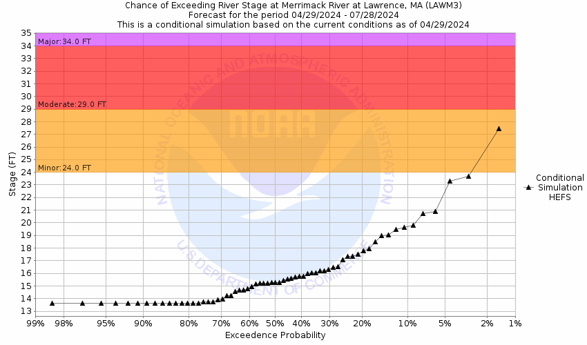
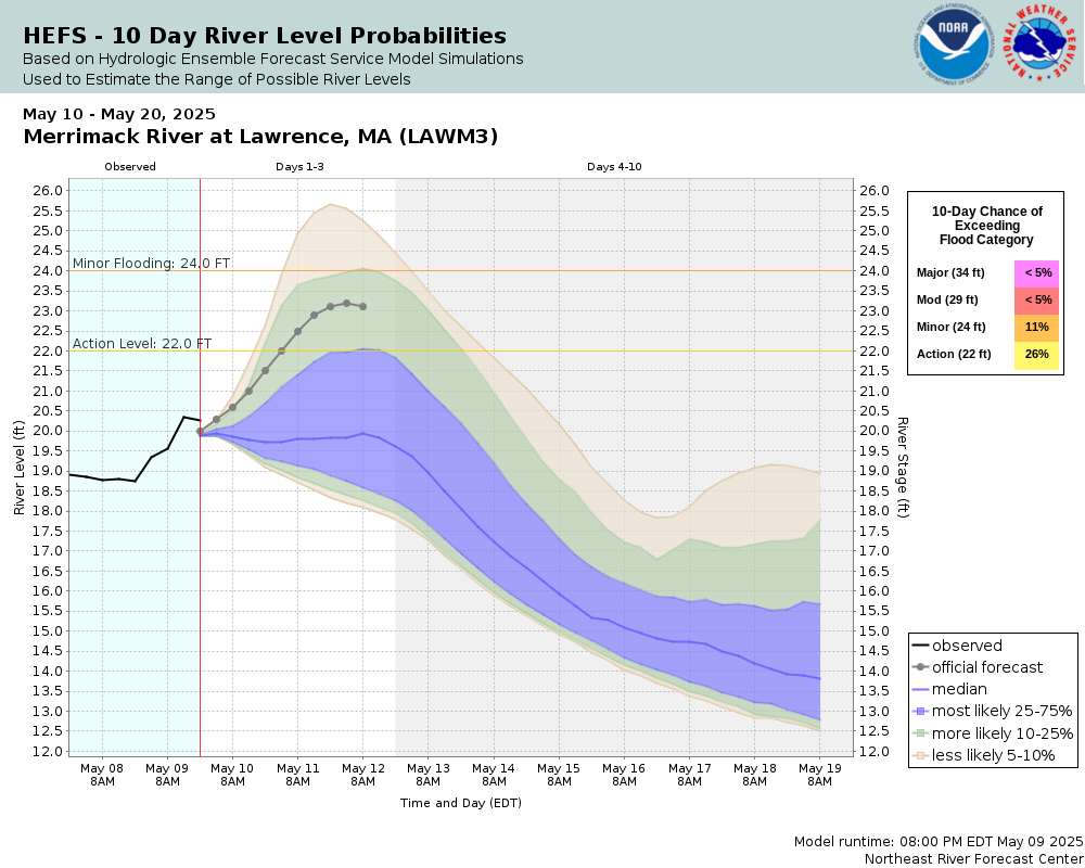
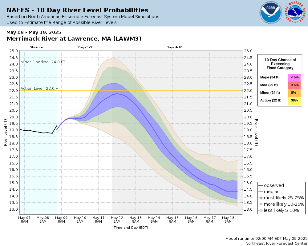
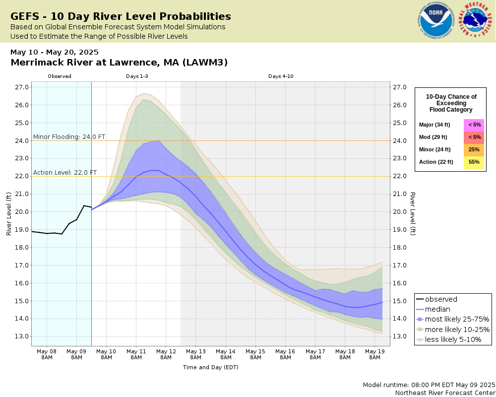
Potential River Levels Used to Estimate the Chance of Flooding and
the Range of Possible River Levels
10 Day (HEFS)
7 Day (NAEFS)
7 Day (GEFS)
Note: Use the official hydrograph at the top of this web page
for river levels within the next 72 hours.
Click individual graphics to
enlarge.
Collaborative Agencies
The National Weather Service prepares its forecasts and other services in collaboration with agencies like the US Geological Survey, US Bureau of Reclamation, US Army Corps of Engineers, Natural Resource Conservation Service, National Park Service, ALERT Users Group, Bureau of Indian Affairs, and many state and local emergency managers across the country. For details, please click here.
NWS Information
National Weather Service
Boston / Norton Weather Forecast Office
46 Commerce Way
Norton, MA 02766
(508) 622-3250 Ask Questions/Webmaster
Page last modified: 2-Nov-2020 7:30 PM