Skip Navigation Link weather.gov  
NOAA logo - Click to go to the NOAA homepage National Weather Service NWS logo - Click to go to the NWS homepage
Advanced Hydrologic Prediction Service
Image background of Navigation bar Left
Navigation Bar End Cap


This probabilistic forecast is issued by the Northeast River Forecast Center.
tab left off Hydrograph tab right off tab left off River at a Glance tab right off tab left off Download tab right off tab left on tab right on
About this graph
Forecasts for the Tonawanda Creek at Batavia are issued routinely year-round.
Return to Area Map

Downstream Gauge Downstream Gauge - at Rapids
Zoom Level:16
Flood Categories (in feet)
Major Flood Stage: 12
Moderate Flood Stage: 10
Flood Stage: 9
Action Stage: 7
Low Stage (in feet): -9999

Historic Crests
(1) 13.85 ft on 04/06/1947
(2) 13.73 ft on 03/29/1950
(3) 13.44 ft on 03/02/1955
(4) 12.70 ft on 03/31/1960
(5) 12.45 ft on 02/25/1985
Show More Historic Crests

(P): Preliminary values subject to further review.

Recent Crests
(1) 10.07 ft on 02/24/2022
(2) 10.29 ft on 02/19/2022
(3) 10.05 ft on 01/13/2018
(4) 9.88 ft on 07/14/2017
(5) 9.02 ft on 11/25/2014
Show More Recent Crests

(P): Preliminary values subject to further review.

Low Water Records
(1) 0.89 ft on 09/09/2008
(2) 1.20 ft on 07/19/1983
(3) 1.30 ft on 08/03/1999
(4) 1.30 ft on 09/03/1995
(5) 1.50 ft on 07/15/1998
KML Image
Gauge LocationGauge Map Marker
Disclaimer
Latitude/Longitude Disclaimer: The gauge location shown in the above map is the approximate location based on the latitude/longitude coordinates provided to the NWS by the gauge owner.
Flood Impacts & Photos Collapse
If you notice any errors in the below information, please contact our Webmaster
12 Major flood, considerable residential and commercial flooding from the west side of Batavia through East Pembroke. Widespread flooding in low lying areas and feeder streams along the entire reach of Tonawanda Creek, including the Tonawanda Indian Reservation and extending into the Iroquois National Wildlife Refuge.
10 Moderate flood, flooding along West Main Street and South Main Street in Batavia and along the creek from Batavia to East Pembroke, extending to the Tonawanda Indian Reservation. Flooding will mainly impact roads, with some residential and commerical flooding possible.
9 Flood stage, some flooding in Batavia, possibly impacting Kibbe Park, Walnut Street, and Law Street. Flooding in rural areas of Alexander and the lowlands of the Alabama Swamps with some road closures likely.
7 Action stage, high flows. Minor impact on some rural roads north of Alexander.

Other Real-time and/or Archive Data Sources:

Additional Information Collapse
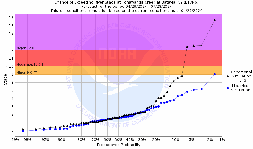
Potential River Levels
Used to Estimate the Chance of Flooding and the Range of Possible River Levels
10 Day (HEFS) 7 Day (NAEFS) 7 Day (GEFS)
HEFS Ensemble NAEFS Ensemble GEFS Ensemble

Note: Use the official hydrograph at the top of this web page for river levels within the next 48 hours.

See the Product Description Document link for more details on the interpretation of the 3,7 day graphics.

Click individual graphics to enlarge.

Observations courtesy of the U.S. Geological Survey.
Collaborative Agencies Collapse
The National Weather Service prepares its forecasts and other services in collaboration with agencies like the US Geological Survey, US Bureau of Reclamation, US Army Corps of Engineers, Natural Resource Conservation Service, National Park Service, ALERT Users Group, Bureau of Indian Affairs, and many state and local emergency managers across the country. For details, please click here.
NWS Information
National Weather Service
Buffalo Weather Forecast Office
587 Aero Drive
Buffalo, NY 14225-1405
(716) 565-0204
Ask Questions/Webmaster
Page last modified: 2-Nov-2020 7:30 PM
Disclaimer
Credits
Glossary
Privacy Policy
About Us
Career Opportunities