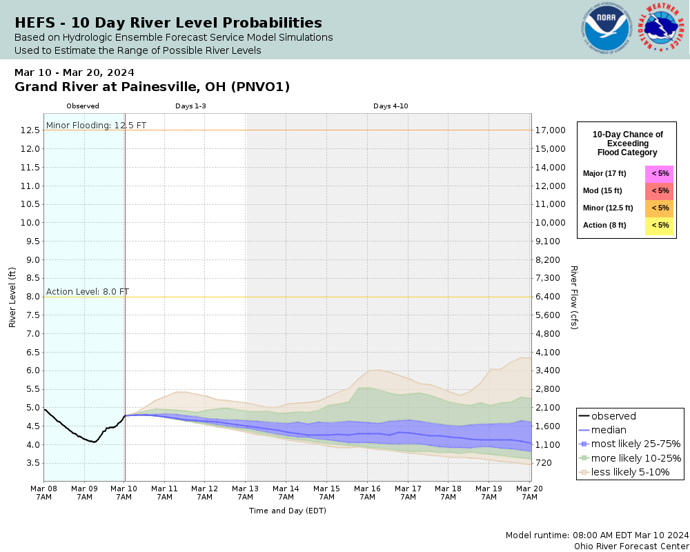
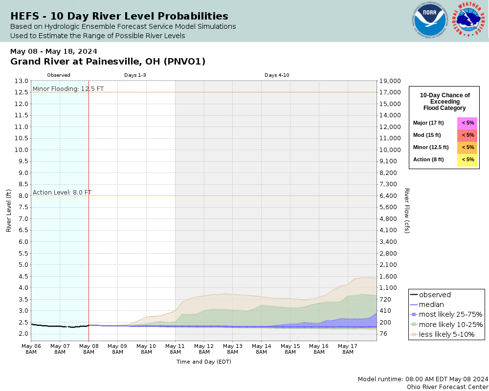
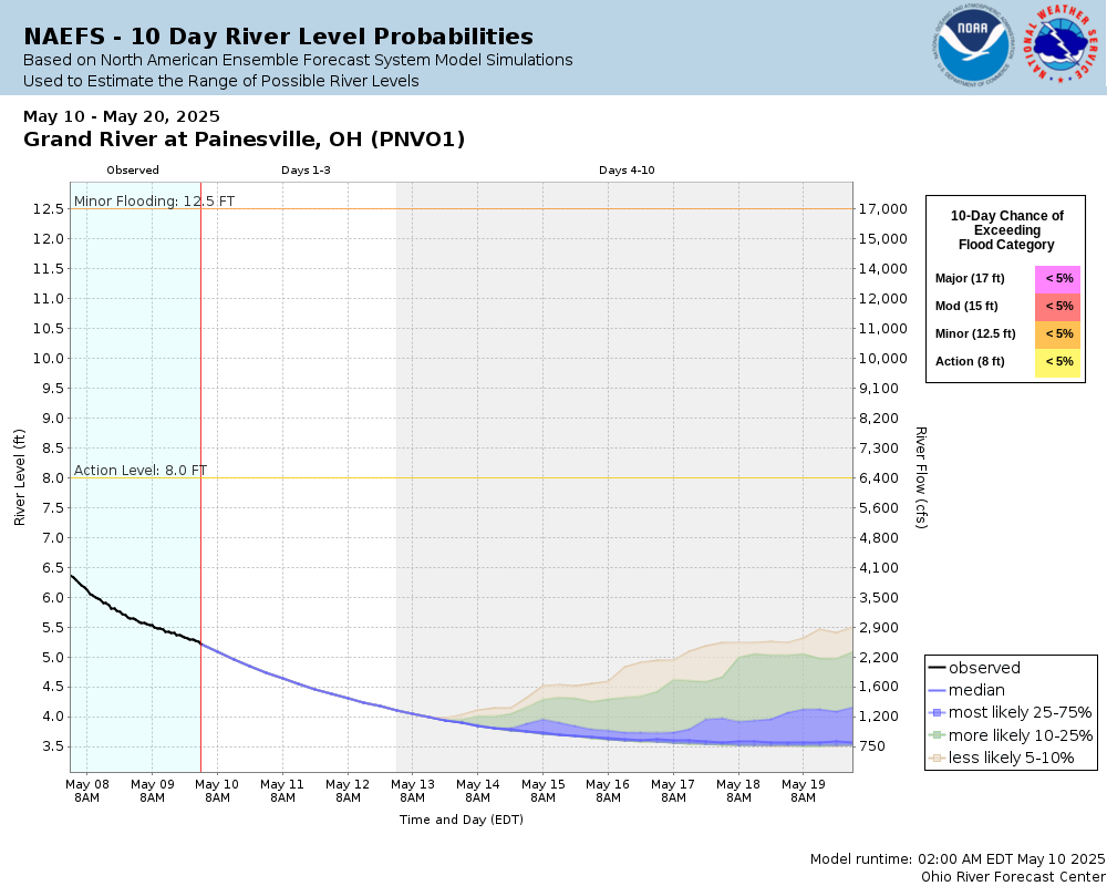
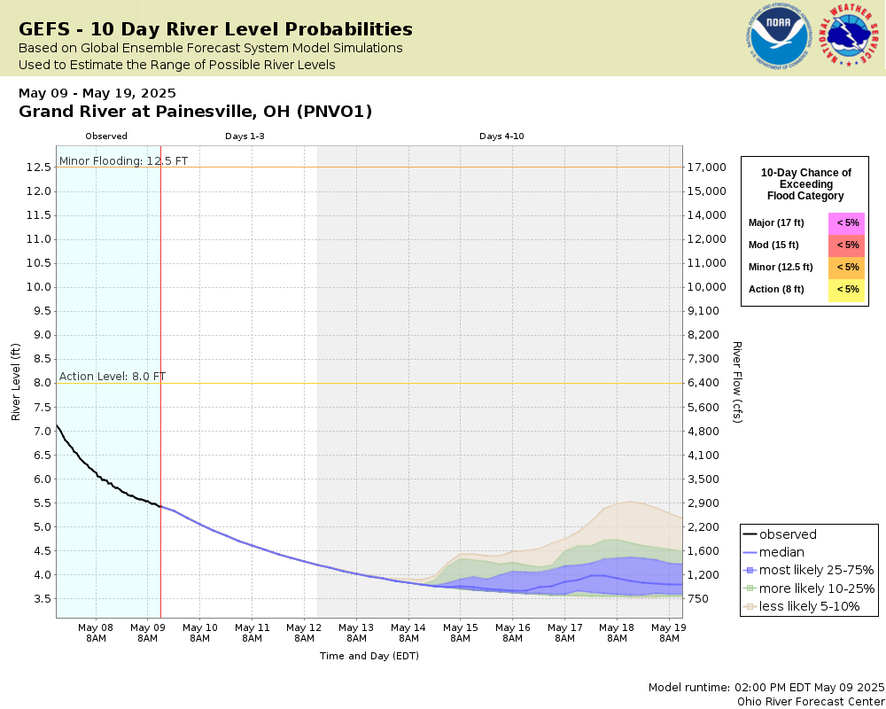
Skip Navigation Link weather.gov  
NOAA logo - Click to go to the NOAA homepage National Weather Service NWS logo - Click to go to the NWS homepage
Advanced Hydrologic Prediction Service
Image background of Navigation bar Left
Navigation Bar End Cap


This probabilistic forecast is issued by the Ohio River Forecast Center.
tab left off Hydrograph tab right off tab left off River at a Glance tab right off tab left off Download tab right off tab left on tab right on
Experimental Short Range Forecast Uncertainty (AHPS) - External Links: Product Description Document | Customer Survey
About this graph
Forecasts for the Grand River at Painesville are issued routinely year-round.
Return to Area Map

Zoom Level:16
Flood Categories (in feet)
Major Flood Stage: 17
Moderate Flood Stage: 15
Flood Stage: 12.5
Action Stage: 8
Low Stage (in feet): -9999

Historic Crests
(1) 19.35 ft on 07/28/2006
(2) 13.70 ft on 02/06/2008
(3) 13.25 ft on 02/28/2011
(4) 13.16 ft on 12/25/1979
(5) 13.07 ft on 06/11/1986
(6) 12.93 ft on 05/26/1989
(7) 12.55 ft on 02/17/1976
(8) 12.52 ft on 03/15/1978
(9) 12.11 ft on 02/24/1985
(10) 12.01 ft on 02/19/1981
Show More Historic Crests

(P): Preliminary values subject to further review.

Recent Crests
(1) 9.60 ft on 05/07/2017
(2) 8.54 ft on 04/01/2017
(3) 11.30 ft on 01/12/2017
(4) 13.25 ft on 02/28/2011
(5) 10.38 ft on 03/12/2010
(6) 11.32 ft on 02/12/2009
(7) 13.70 ft on 02/06/2008
(8) 8.79 ft on 01/09/2008
(9) 8.15 ft on 12/12/2007
(10) 11.15 ft on 03/15/2007
Show More Recent Crests

(P): Preliminary values subject to further review.

Low Water Records
Currently none available.
KML Image
Gauge LocationGauge Map Marker
Disclaimer
Latitude/Longitude Disclaimer: The gauge location shown in the above map is the approximate location based on the latitude/longitude coordinates provided to the NWS by the gauge owner.
Flood Impacts & Photos Collapse
If you notice any errors in the below information, please contact our Webmaster
28 River gage flooded. Historic flooding along the river. Major damage to property in low lying areas.
19.5 Record flooding. Major flooding in the City of Painesville. Route 2 and the Richmond Street bridges will be flooded. Homes and businesses along Steele and Grand River Avenues, as well as Huntington Road will be completely inundated. The City of Painesville Pollution Control Plant will be flooded.
19 FEMA 0.2 percent flood level. Major flooding in the City of Painesville. Route 2 and the Richmond Street bridges will be flooded. Homes and business along Steele and Grand River Avenue, as well as Huntington Road will be completely inundated. The City of Painesville Pollution Control Plant will be flooded.
17 FEMA 1 percent flood level. Steele and Grand River Avenues completely flooded. Painesville City Pollution Control Plant inundated. Kiwanis recreational park will be flooded. Rising water may inundate businesses near the Route 20 bridge.
16 Steele and Grand River Avenues flooded with evacuations needed. Painesville City Pollution Control Plant threatened. Kiwanis recreational park will begin to flood.
15 River near bankful along Grand River and Steele Avenues. Homes and apartments threatened.
13 Yacht club near mouth of the river threatened by flood waters.
8.5 Low land flooding adjacent to the river in the metropark.
8 Water levels will overrun the banks along the metropark south of Painesville.
Photos
(1) USGS Painesville River Gage located on the downstream left abutment of the State Highway 84 (Walnut
(2) Another photo of the USGS water-stage recorder river gage on the Grand River in Painesville. Photo t

Other Real-time and/or Archive Data Sources:

Additional Information Collapse
Potential River Levels - Used to
Potential River Levels
Used to Estimate the Chance of Flooding and the Range of Possible River Levels
10 Day (HEFS) 10 Day (NAEFS) 10 Day (GEFS)
HEFS Ensemble NAEFS Ensemble GEFS Ensemble

Note: Use the official hydrograph at the top of this web page for river levels within the next 48 hours.

See the Product Description Document link for more details on the interpretation of the 10 day graphics.

Click individual graphics to enlarge.

Collaborative Agencies Collapse
The National Weather Service prepares its forecasts and other services in collaboration with agencies like the US Geological Survey, US Bureau of Reclamation, US Army Corps of Engineers, Natural Resource Conservation Service, National Park Service, ALERT Users Group, Bureau of Indian Affairs, and many state and local emergency managers across the country. For details, please click here.
NWS Information
National Weather Service
Cleveland Weather Forecast Office
925 Keynote Circle, Suite #314
Brooklyn Heights, OH 44131
(216) 416-2900
Ask Questions/Webmaster
Page last modified: 2-Nov-2020 7:30 PM
Disclaimer
Credits
Glossary
Privacy Policy
About Us
Career Opportunities