Latitude/Longitude Disclaimer: The gauge location shown in the above map
is the approximate location based on the latitude/longitude coordinates
provided to the NWS by the gauge owner.
Flood Impacts & Photos
If you notice any errors in the below information, please contact our Webmaster
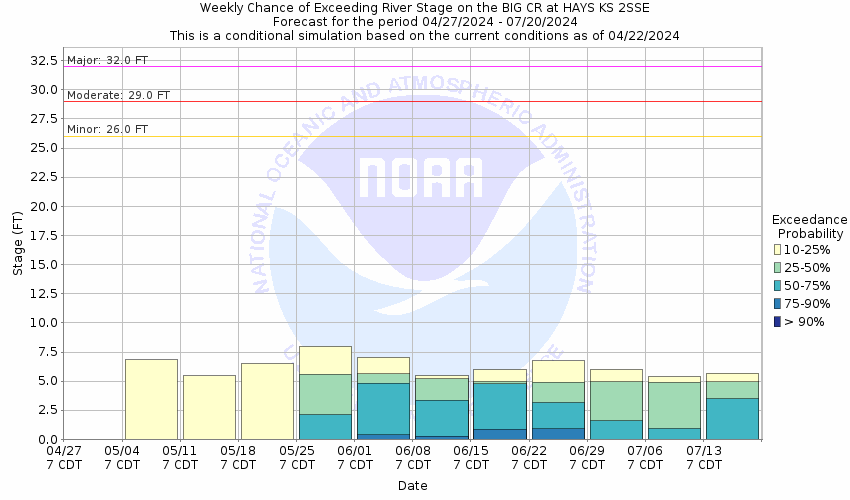
32
Prepare for major right bank (south side) flooding of 6 feet or more along Big Creek from Hays to Munjor.
29
Prepare for moderate right bank (south side) flooding of three feet or more along Big Creek from Hays to Munjor. Move livestock away from Big Creek to higher ground. At a stage of 29 feet, the city of Hays is not directly threatened by flooding from Big Creek.
27
Prepare for minor right bank (south side) overflows of 1 foot or more along Big Creek from Hays to Munjor. For safety, move livestock away from the main creek channel. At a stage of 27 feet, the city of Hays is not directly threatened by flooding from Big Creek.
26
Prepare for minor right bank (south side) overflows along Big Creek from Hays to Munjor. For safety, move livestock away from the main creek channel. At a stage of 26 feet, the city of Hays is not directly threatened by flooding from Big Creek.
The National Weather Service prepares its forecasts and other services in collaboration with agencies like the US Geological Survey, US Bureau of Reclamation, US Army Corps of Engineers, Natural Resource Conservation Service, National Park Service, ALERT Users Group, Bureau of Indian Affairs, and many state and local emergency managers across the country. For details, please click here.
NWS Information
National Weather Service
Dodge City Weather Forecast Office
104 Airport Rd
Dodge City, KS 67801
(620) 225-6514 Ask Questions/Webmaster
Page last modified: 2-Nov-2020 7:29 PM


