Skip Navigation Link weather.gov  
NOAA logo - Click to go to the NOAA homepage National Weather Service NWS logo - Click to go to the NWS homepage
Advanced Hydrologic Prediction Service
Image background of Navigation bar Left
Navigation Bar End Cap


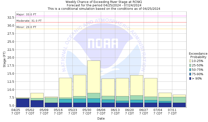
This probabilistic forecast is issued by the Arkansas Red-Basin River Forecast Center.
tab left off Hydrograph tab right off tab left off River at a Glance tab right off tab left off Download tab right off tab left on tab right on
About this graph
Forecasts for the Walnut Creek (KS) at Nekoma are issued as needed during times of high water, but are not routinely available.
Return to Area Map

Downstream Gauge Downstream Gauge - at Albert
Zoom Level:16
Flood Categories (in feet)
Major Flood Stage: 33
Moderate Flood Stage: 31
Flood Stage: 29
Action Stage: 26
Low Stage (in feet): -9999

Historic Crests
(1) 34.00 ft on 07/21/1993
(2) 28.59 ft on 05/24/2019
(3) 27.59 ft on 06/09/2001
(4) 25.46 ft on 06/01/1996
Show More Historic Crests

(P): Preliminary values subject to further review.

Recent Crests
(1) 22.75 ft on 05/17/2021
(2) 28.59 ft on 05/24/2019
(3) 19.05 ft on 06/29/2014
(4) 19.14 ft on 05/25/2011
Show More Recent Crests

(P): Preliminary values subject to further review.

Low Water Records
Currently none available.
KML Image
Gauge LocationGauge Map Marker
Disclaimer
Latitude/Longitude Disclaimer: The gauge location shown in the above map is the approximate location based on the latitude/longitude coordinates provided to the NWS by the gauge owner.
Flood Impacts & Photos Collapse
If you notice any errors in the below information, please contact our Webmaster
34 Expect near record to record flooding of five or more feet along Walnut Creek in Rush County from Nekoma, Kansas eastward to the Barton County line, as the creek moves several hundred feet out onto the floodplain. At 34.0 feet, the creek stage will equal the record set on 07/21/1993, when Walnut Creek rose to 34.0 feet. Overflow north of the Nekoma Bridge will be about 700 feet wide at a stage of 34 feet.
33 Expect major flooding of four or more feet along Walnut Creek in Rush County from Nekoma, Kansas eastward to the Barton County line, as the creek moves further out onto the floodplain.
32 Expect moderate flooding of three or more feet along the floodplain adjacent to Walnut Creek in Rush County from Nekoma, Kansas eastward to the Barton County line.
31 Expect moderate flooding of two or more feet along the floodplain immediately adjacent to Walnut Creek in Rush County from Nekoma, Kansas eastward to the Barton County line.
30 Many locations along Walnut Creek will be up to one foot over flood stage as the creek approaches 30 feet.
29 Expect minor flooding along Walnut Creek throughout Rush County. Bar ditches on the north-south road near the river gage will contain three or more feet of water as Walnut Creek rises above 29 feet.
28 Bar ditches on the north-south road near the river gage will contain two or more feet of water as Walnut Creek rises above 28 feet.
27 Bar ditches on the north-south road near the river gage will contain one or more feet of water as Walnut Creek rises above 27 feet.
26 Bar ditches on the north-south road near the river gage will begin to fill with water as Walnut Creek rises above 26 feet.

Other Real-time and/or Archive Data Sources:

Collaborative Agencies Collapse
The National Weather Service prepares its forecasts and other services in collaboration with agencies like the US Geological Survey, US Bureau of Reclamation, US Army Corps of Engineers, Natural Resource Conservation Service, National Park Service, ALERT Users Group, Bureau of Indian Affairs, and many state and local emergency managers across the country. For details, please click here.
NWS Information
National Weather Service
Dodge City Weather Forecast Office
104 Airport Rd
Dodge City, KS 67801
(620) 225-6514
Ask Questions/Webmaster
Page last modified: 2-Nov-2020 7:29 PM
Disclaimer
Credits
Glossary
Privacy Policy
About Us
Career Opportunities