Skip Navigation Link weather.gov  
NOAA logo - Click to go to the NOAA homepage National Weather Service NWS logo - Click to go to the NWS homepage
Advanced Hydrologic Prediction Service
Image background of Navigation bar Left
Navigation Bar End Cap


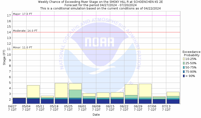
This probabilistic forecast is issued by the Missouri Basin River Forecast Center.
tab left off Hydrograph tab right off tab left off River at a Glance tab right off tab left off Download tab right off tab left on tab right on
About this graph
Forecasts for the Smoky Hill River below Schoenchen are issued as needed during times of high water, but are not routinely available.
Return to Area Map

Zoom Level:16
Flood Categories (in feet)
Major Flood Stage: 17
Moderate Flood Stage: 14
Flood Stage: 11
Action Stage: 10
Low Stage (in feet): -9999

Historic Crests
(1) 17.60 ft on 07/21/1993
(2) 13.57 ft on 04/14/1987
(3) 12.42 ft on 06/01/2007
(4) 12.22 ft on 05/22/2019
(5) 11.42 ft on 10/10/2018
(6) 10.59 ft on 08/25/2019
(7) 10.52 ft on 08/24/2010
Show More Historic Crests

(P): Preliminary values subject to further review.

Recent Crests
(1) 10.59 ft on 08/25/2019
(2) 12.22 ft on 05/22/2019
(3) 11.42 ft on 10/10/2018
(4) 10.45 ft on 04/17/2016
(5) 9.70 ft on 07/10/2014
(6) 10.52 ft on 08/24/2010
(7) 12.42 ft on 06/01/2007
Show More Recent Crests

(P): Preliminary values subject to further review.

Low Water Records
(1) 1.40 ft on 01/01/1980
Show More Low Water Records
KML Image
Gauge LocationGauge Map Marker
Disclaimer
Latitude/Longitude Disclaimer: The gauge location shown in the above map is the approximate location based on the latitude/longitude coordinates provided to the NWS by the gauge owner.
Flood Impacts & Photos Collapse
If you notice any errors in the below information, please contact our Webmaster
17 Prepare for major flooding along the Smoky Hill River from Schoenchen throughout southeastern Ellis County. Extensive flooding of lowlands will occur, with floodwaters of six feet or more possible near the main river channel.
14 Expect moderate flooding of three feet or more along the Smoky Hill River from Schoenchen through the southeastern portion of Ellis County. Some county roads adjacent to the river will be impassable due to rising waters.
13 Expect minor flooding of two feet or more along the Smoky Hill River from Schoenchen through the southeastern portions of Ellis County, as the river moves further out onto the floodplain. Some county roads in close proximity to the river may become impassible as rising waters cover the roads.
11 Expect minor overflows along the Smoky Hill River in the vicinity of Schoenchen, as lowland flooding of pasturelands initiates immediately adjacent to the river.
Photos
(1) River Gage View Looking North
(2) Staff Gages (backup) looking north

Other Real-time and/or Archive Data Sources:

Additional Information Collapse
How low could the river get?
Collaborative Agencies Collapse
The National Weather Service prepares its forecasts and other services in collaboration with agencies like the US Geological Survey, US Bureau of Reclamation, US Army Corps of Engineers, Natural Resource Conservation Service, National Park Service, ALERT Users Group, Bureau of Indian Affairs, and many state and local emergency managers across the country. For details, please click here.
NWS Information
National Weather Service
Dodge City Weather Forecast Office
104 Airport Rd
Dodge City, KS 67801
(620) 225-6514
Ask Questions/Webmaster
Page last modified: 2-Nov-2020 7:29 PM
Disclaimer
Credits
Glossary
Privacy Policy
About Us
Career Opportunities