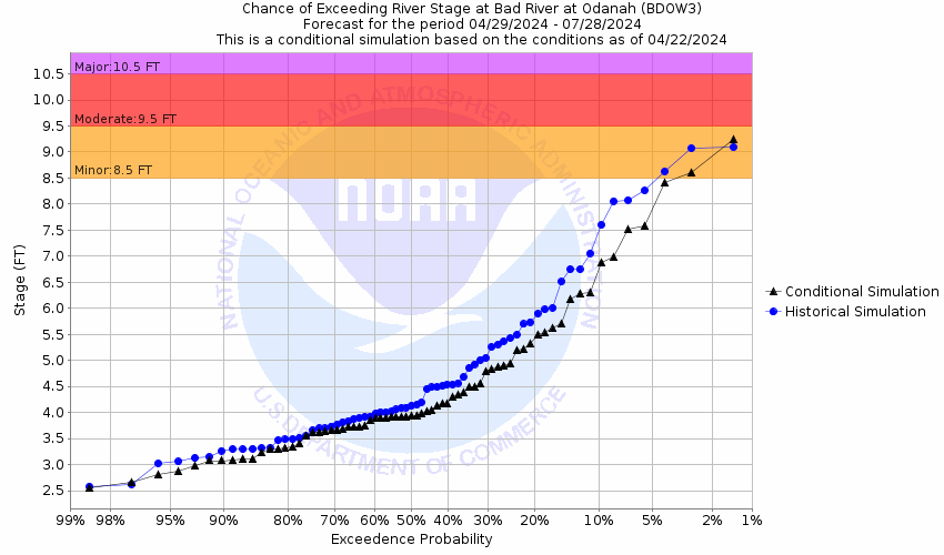
Forecasts for the Bad River (WI) at Odanah are issued as needed during times of high water, but are not routinely available.Vertical datum height surveyed by the USGS
Latitude/Longitude Disclaimer: The gauge location shown in the above map
is the approximate location based on the latitude/longitude coordinates
provided to the NWS by the gauge owner.
Flood Impacts & Photos
If you notice any errors in the below information, please contact our Webmaster
11.78
Flood of 2016 high water mark. Major flooding to US Highway 2. Water over the bridge on Government Road.
9.3
Water begins to flow onto US Highway 2 .35 Miles East of Government Road. Water floods Kakagon Slough causing water to encroach on the Fish hatchery and homes on Kakagon Rd. Water begins flooding the Pow wow grounds.
9
Many roads and several homes are impacted by flood waters in the Old Odanah area. Government Road south of US Highway 2, Miller Road and State Road will see areas of water flowing over the roadway.
8.5
Minor flooding begins as water encroaches on State Street through the Sugar Bush.
The National Weather Service prepares its forecasts and other services in collaboration with agencies like the US Geological Survey, US Bureau of Reclamation, US Army Corps of Engineers, Natural Resource Conservation Service, National Park Service, ALERT Users Group, Bureau of Indian Affairs, and many state and local emergency managers across the country. For details, please click here.
NWS Information
National Weather Service
Duluth Weather Forecast Office
5027 Miller Trunk Highway
Duluth, MN 55811
(218) 729-6697 Ask Questions/Webmaster
Page last modified: 2-Nov-2020 7:29 PM