Skip Navigation Link weather.gov  
NOAA logo - Click to go to the NOAA homepage National Weather Service NWS logo - Click to go to the NWS homepage
Advanced Hydrologic Prediction Service
Image background of Navigation bar Left
Navigation Bar End Cap


This probabilistic forecast is issued by the Missouri Basin River Forecast Center.
tab left off Hydrograph tab right off tab left off River at a Glance tab right off tab left off Download tab right off tab left on tab right on
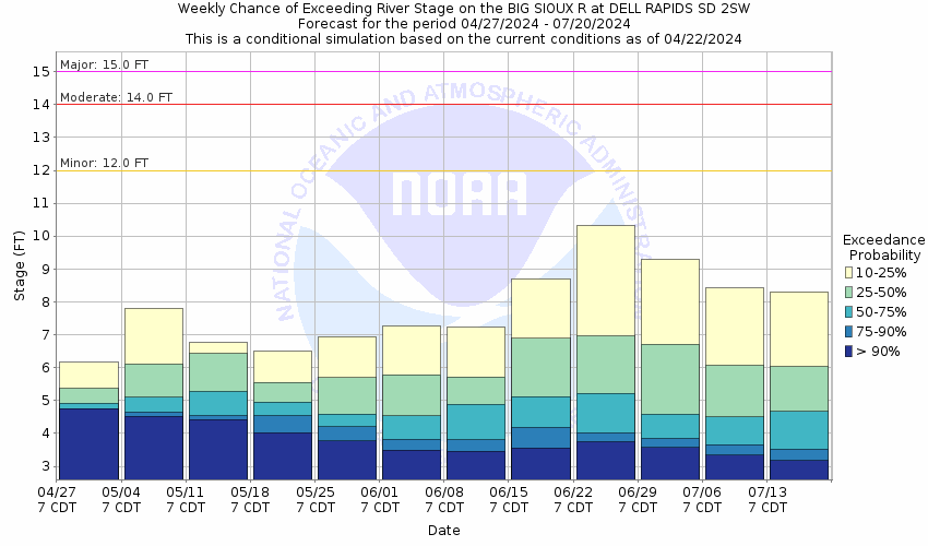
About this graph
Forecasts for the Big Sioux River near Dell Rapids are issued as needed during times of high water, but are not routinely available.
Return to Area Map

Downstream Gauge Downstream Gauge - at Sioux Falls I-90
Zoom Level:14
Flood Categories (in feet)
Major Flood Stage: 15
Moderate Flood Stage: 14
Flood Stage: 12
Action Stage: 11
Low Stage (in feet): -9999

Historic Crests
(1) 16.70 ft on 09/13/2019
(2) 16.47 ft on 04/09/1969
(3) 16.29 ft on 09/25/2010
(4) 16.02 ft on 03/15/2007
(5) 15.69 ft on 03/24/2019
Show More Historic Crests

(P): Preliminary values subject to further review.

Recent Crests
(1) 12.90 ft on 04/10/2023
(2) 9.56 ft on 05/13/2022
(3) 7.32 ft on 04/13/2021
(4) 13.38 ft on 03/14/2020
(5) 16.70 ft on 09/13/2019
Show More Recent Crests

(P): Preliminary values subject to further review.

Low Water Records
Currently none available.
KML Image
Gauge LocationGauge Map Marker
Disclaimer
Latitude/Longitude Disclaimer: The gauge location shown in the above map is the approximate location based on the latitude/longitude coordinates provided to the NWS by the gauge owner.
Flood Impacts & Photos Collapse
If you notice any errors in the below information, please contact our Webmaster
21 The bridge at the gauge on 248th St is overtopped and several outbuildings near the gauge are flooded.
19 The bridge on 250th Street just west of Baltic is overtopped.
17.5 Water reaches the bottom of the bridge on 250th Street west of Baltic.
16.5 Water reaches the bottom of the bridge on 254th St.
16 248th Street east of the gauge is flooded, along with several other county roads. Flooding will affect the city of Renner with water going over the main road in town.
15.5 County Road 130 in Renner is flooded.
15 Some homes in Renner are flooded, and the Jaycee Camp between Baltic and Renner is also flooded.
14.5 250th Street west of Baltic is flooded, River Park Road in Baltic is flooded, and some homes and businesses along 1st Avenue are flooded.
14 Significant amounts of agricultural lands are flooded through the basin, and River Park in Baltic begins to flood.
12 Agricultural lands along the lower banks of the river begin to flood.
Photos
(1) Downstream View (8/23/2023)
(2) Upstream View (8/23/2023)

Other Real-time and/or Archive Data Sources:

Additional Information Collapse

USGS 7-Day Streamflow Historical Comparison USGS WaterWatch Webpage

How low could the river get?

Collaborative Agencies Collapse
The National Weather Service prepares its forecasts and other services in collaboration with agencies like the US Geological Survey, US Bureau of Reclamation, US Army Corps of Engineers, Natural Resource Conservation Service, National Park Service, ALERT Users Group, Bureau of Indian Affairs, and many state and local emergency managers across the country. For details, please click here.
NWS Information
National Weather Service
Sioux Falls Weather Forecast Office
26 Weather Lane
Sioux Falls, SD 57104-0198
(605) 330-4247
Ask Questions/Webmaster
Page last modified: 2-Nov-2020 7:29 PM
Disclaimer
Credits
Glossary
Privacy Policy
About Us
Career Opportunities