Skip Navigation Link weather.gov  
NOAA logo - Click to go to the NOAA homepage National Weather Service NWS logo - Click to go to the NWS homepage
Advanced Hydrologic Prediction Service
Image background of Navigation bar Left
Navigation Bar End Cap


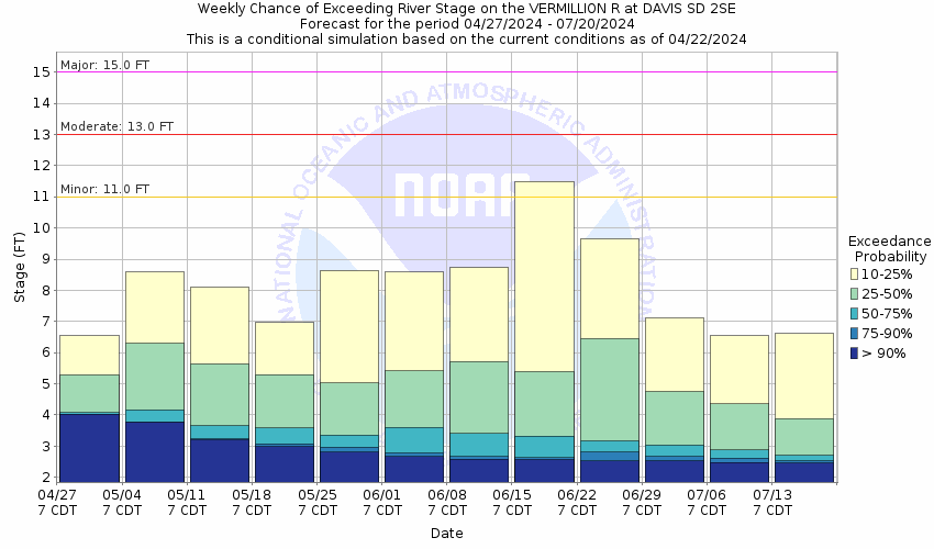
This probabilistic forecast is issued by the Missouri Basin River Forecast Center.
tab left off Hydrograph tab right off tab left off River at a Glance tab right off tab left off Download tab right off tab left on tab right on
About this graph
Forecasts for the Vermillion River near Davis are issued as needed during times of high water, but are not routinely available.
Return to Area Map

Downstream Gauge Downstream Gauge - near Wakonda
Zoom Level:14
Flood Categories (in feet)
Major Flood Stage: 15
Moderate Flood Stage: 13
Flood Stage: 11
Action Stage: 10
Low Stage (in feet): -9999

Historic Crests
(1) 16.40 ft on 03/15/2010
(2) 16.20 ft on 03/15/2019
(3) 15.75 ft on 04/07/1969
(4) 15.60 ft on 07/05/1993
(5) 15.10 ft on 06/22/1984
Show More Historic Crests

(P): Preliminary values subject to further review.

Recent Crests
(1) 9.59 ft on 04/03/2023
(2) 12.20 ft on 03/07/2020
(3) 16.20 ft on 03/15/2019
(4) 14.40 ft on 06/23/2018
(5) 12.60 ft on 06/18/2014
Show More Recent Crests

(P): Preliminary values subject to further review.

Low Water Records
Currently none available.
KML Image
Gauge LocationGauge Map Marker
Disclaimer
Latitude/Longitude Disclaimer: The gauge location shown in the above map is the approximate location based on the latitude/longitude coordinates provided to the NWS by the gauge owner.
Flood Impacts & Photos Collapse
If you notice any errors in the below information, please contact our Webmaster
20.5 The bridge at the gauge site on 461st Ave is overtopped.
17 The lowest portions of 461st Ave north of the gauge site begin to flood.
16.5 The bridge 1 mile west of Davis on Highway 18 is overtopped, and the water reaches the bottom of the bridge 1 mile northwest of Davis on 460th Avenue.
15.5 Water reaches the bottom of the bridge 1 mile southwest of Davis on 286th Street.
15 Major flooding of agricultural land begins, flooding approximately 25000 acres between Davis and Vermillion. The town of Davis and several rural roads also begin flooding.
14.5 The higher banks and levees get overtopped, and flooding of some rural roads south of Davis begins. Also 280th Street between 459th and 460th Avenue is flooded.
13.5 Water reaches the bottom of the bridge 1 mile west of Davis on Highway 18.
13 Moderate flooding of agricultural land begins.
12 Several houses just west of Davis are surrounded by water.
11 Agricultural flooding begins
10 The lowest banks begin to be overtopped with some low lying areas flooded.
Photos
(1) Downstream View (6/13/2023)
(2) Upstream View (6/13/2023)
Additional Information Collapse
How low could the river get?
Collaborative Agencies Collapse
The National Weather Service prepares its forecasts and other services in collaboration with agencies like the US Geological Survey, US Bureau of Reclamation, US Army Corps of Engineers, Natural Resource Conservation Service, National Park Service, ALERT Users Group, Bureau of Indian Affairs, and many state and local emergency managers across the country. For details, please click here.
NWS Information
National Weather Service
Sioux Falls Weather Forecast Office
26 Weather Lane
Sioux Falls, SD 57104-0198
(605) 330-4247
Ask Questions/Webmaster
Page last modified: 2-Nov-2020 7:29 PM
Disclaimer
Credits
Glossary
Privacy Policy
About Us
Career Opportunities