Skip Navigation Link weather.gov  
NOAA logo - Click to go to the NOAA homepage National Weather Service NWS logo - Click to go to the NWS homepage
Advanced Hydrologic Prediction Service
Image background of Navigation bar Left
Navigation Bar End Cap


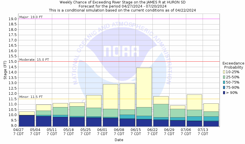
This probabilistic forecast is issued by the Missouri Basin River Forecast Center.
tab left off Hydrograph tab right off tab left off River at a Glance tab right off tab left off Download tab right off tab left on tab right on
About this graph
Forecasts for the James River at Huron are issued as needed during times of high water, but are not routinely available.
Return to Area Map

Upstream Gauge - near Redfield Upstream Gauge Downstream Gauge Downstream Gauge - near Forestburg
Zoom Level:14
Flood Categories (in feet)
Major Flood Stage: 19
Moderate Flood Stage: 15
Flood Stage: 11.5
Action Stage: 10.5
Low Stage (in feet): -9999

Historic Crests
(1) 21.28 ft on 04/06/1997
(2) 20.07 ft on 03/26/2011
(3) 19.72 ft on 03/25/2010
(4) 18.14 ft on 04/10/2001
(5) 17.58 ft on 05/07/2007
Show More Historic Crests

(P): Preliminary values subject to further review.

Recent Crests
(1) 15.69 ft on 04/24/2023
(2) 13.16 ft on 06/13/2022
(3) 9.95 ft on 04/18/2021
(4) 16.75 ft on 03/21/2020
(5) 17.25 ft on 04/24/2019
Show More Recent Crests

(P): Preliminary values subject to further review.

Low Water Records
Currently none available.
KML Image
Gauge LocationGauge Map Marker
Disclaimer
Latitude/Longitude Disclaimer: The gauge location shown in the above map is the approximate location based on the latitude/longitude coordinates provided to the NWS by the gauge owner.
Flood Impacts & Photos Collapse
If you notice any errors in the below information, please contact our Webmaster
25.5 Water overtops the dike at the wastewater treatment plant.
22 Riverside Park in Huron begins to flood.
21.5 Water reaches the bottom of the bridge on Highway 14 and reaches the top of the dike in Memorial Park.
20.5 Memorial Park in Huron will be flooded.
19.5 Hwy 14 may begin flooding west of the bridge. Water reaches the bottom of the bridge at the gaging location.
19 Most county roads along the river east of Highway 37 are flooded.
17 3rd Street east of the bridge in Huron begins flooding.
16.5 Portions of Jersey, Riverside, and Sherman may begin flooding.
15 Approximately 16000 acres of agricultural land around Huron will be flooded. The lowest portion of Jersey and Waibel Dr may also be flooded if flow from the creek is high.
14 A few county and township roads in Beadle County will be flooded.
11.5 Rural and agricultural areas begin to experience flooding
10.5 The lowest banks begin to be overtopped flooding low lying area near the river.
Photos
(1) Downstream View (6/6/2023)
(2) Upstream View (6/6/2023)

Other Real-time and/or Archive Data Sources:

Additional Information Collapse

Live River Camera via USGS HIVIS Webpage


USGS 7-Day Streamflow Historical Comparison USGS WaterWatch Webpage

How low could the river get?

Collaborative Agencies Collapse
The National Weather Service prepares its forecasts and other services in collaboration with agencies like the US Geological Survey, US Bureau of Reclamation, US Army Corps of Engineers, Natural Resource Conservation Service, National Park Service, ALERT Users Group, Bureau of Indian Affairs, and many state and local emergency managers across the country. For details, please click here.
NWS Information
National Weather Service
Sioux Falls Weather Forecast Office
26 Weather Lane
Sioux Falls, SD 57104-0198
(605) 330-4247
Ask Questions/Webmaster
Page last modified: 2-Nov-2020 7:29 PM
Disclaimer
Credits
Glossary
Privacy Policy
About Us
Career Opportunities