Skip Navigation Link weather.gov  
NOAA logo - Click to go to the NOAA homepage National Weather Service NWS logo - Click to go to the NWS homepage
Advanced Hydrologic Prediction Service
Image background of Navigation bar Left
Navigation Bar End Cap


This probabilistic forecast is issued by the North Central River Forecast Center.
tab left off Hydrograph tab right off tab left off River at a Glance tab right off tab left off Download tab right off tab left on tab right on
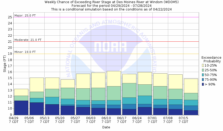
About this graph
Forecasts for the West Fork Des Moines River above Windom are issued as needed during times of high water, but are not routinely available.
Return to Area Map

Upstream Gauge - near Avoca Upstream Gauge Downstream Gauge Downstream Gauge - at Jackson
Zoom Level:14
Flood Categories (in feet)
Major Flood Stage: 25
Moderate Flood Stage: 21
Flood Stage: 19
Action Stage: 17
Low Stage (in feet): -9999

Historic Crests
(1) 24.70 ft on 07/10/1969
(2) 23.40 ft on 07/07/2018
(3) 23.01 ft on 03/23/2019
(4) 23.00 ft on 09/24/2010
(5) 21.90 ft on 04/04/1984
Show More Historic Crests

(P): Preliminary values subject to further review.

Recent Crests
(1) 18.13 ft on 04/17/2023
(2) 17.64 ft on 06/13/2022
(3) 12.57 ft on 04/12/2021
(4) 19.77 ft on 03/10/2020
(5) 23.01 ft on 03/23/2019
Show More Recent Crests

(P): Preliminary values subject to further review.

Low Water Records
Currently none available.
KML Image
Gauge LocationGauge Map Marker
Disclaimer
Latitude/Longitude Disclaimer: The gauge location shown in the above map is the approximate location based on the latitude/longitude coordinates provided to the NWS by the gauge owner.
Flood Impacts & Photos Collapse
If you notice any errors in the below information, please contact our Webmaster
30 The bridge at the gage location on Country Club Dr is overtopped and nearby homes are flooded. Portions of County Road 13 begin to flood.
27 The main levee at the golf course in Windom is overtopped.
25 Water approaches Hwy 71 in Windom.
24 Water reaches the bottom beams of the bridge on Country Club Dr.
23 Water begins to approach at least a couple home and businesses in Windom. Water also approaches River Rd southeast of 15th Ave and at least one private driveway is flooded off of Country Club Dr.
22 Water begins to approach or flood some some outbuildings near Valley Ln and also south of 6th St.
21 The lower portions of the road through Island Park are overtopped and water approaches a couple of the gravel parking lots on the east side of Hwy 71 in Windom.
19 Lowland flooding begins along several stretches of the river and Island Park in Windom floods in several areas.
18 The boat launch area off of River Rd begins to flood.
17 The lower parking lot on the south side of Island Park begins to flood.
15 The lower banks at Island Park begin to overflow.
Photos
(1) Upstream View
(2) Downstream View

Other Real-time and/or Archive Data Sources:

Additional Information Collapse
Data prior to 1995 is from old staff gage downstream of Island Park in Windom. New zero datum and established flood stage at current gage location were estimated by correlating readings of current and previous gage.
Collaborative Agencies Collapse
The National Weather Service prepares its forecasts and other services in collaboration with agencies like the US Geological Survey, US Bureau of Reclamation, US Army Corps of Engineers, Natural Resource Conservation Service, National Park Service, ALERT Users Group, Bureau of Indian Affairs, and many state and local emergency managers across the country. For details, please click here.
NWS Information
National Weather Service
Sioux Falls Weather Forecast Office
26 Weather Lane
Sioux Falls, SD 57104-0198
(605) 330-4247
Ask Questions/Webmaster
Page last modified: 2-Nov-2020 7:29 PM
Disclaimer
Credits
Glossary
Privacy Policy
About Us
Career Opportunities