Skip Navigation Link weather.gov  
NOAA logo - Click to go to the NOAA homepage National Weather Service NWS logo - Click to go to the NWS homepage
Advanced Hydrologic Prediction Service
Image background of Navigation bar Left
Navigation Bar End Cap


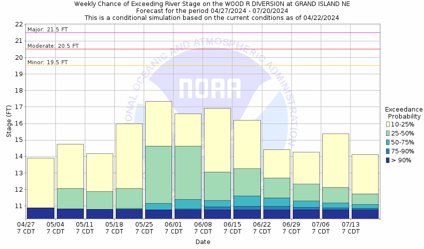
This probabilistic forecast is issued by the Missouri Basin River Forecast Center.
tab left off Hydrograph tab right off tab left off River at a Glance tab right off tab left off Download tab right off tab left on tab right on
About this graph
Forecasts for the Wood River at Grand Island Diversion are issued as needed during times of high water, but are not routinely available.
Return to Area Map

Upstream Gauge - near Alda Upstream Gauge
Zoom Level:14
Flood Categories (in feet)
Major Flood Stage: 21.5
Moderate Flood Stage: 20.5
Flood Stage: 19.5
Action Stage: 18
Low Stage (in feet): -9999

Historic Crests
(1) 18.13 ft on 03/17/2019
(2) 17.10 ft on 06/08/2008
(3) 16.77 ft on 05/27/2020
(4) 15.85 ft on 03/03/2007
(5) 15.51 ft on 06/21/2010
Show More Historic Crests

(P): Preliminary values subject to further review.

Recent Crests
(1) 11.25 ft on 06/16/2022
(2) 14.21 ft on 03/25/2021
(3) 16.77 ft on 05/27/2020
(4) 18.13 ft on 03/17/2019
(5) 13.99 ft on 07/11/2018
Show More Recent Crests

(P): Preliminary values subject to further review.

Low Water Records
Currently none available.
KML Image
Gauge LocationGauge Map Marker
Disclaimer
Latitude/Longitude Disclaimer: The gauge location shown in the above map is the approximate location based on the latitude/longitude coordinates provided to the NWS by the gauge owner.
Flood Impacts & Photos Collapse
If you notice any errors in the below information, please contact our Webmaster
22.5 Water reaches the bottom of the Highway 281 bridge.
21.5 The Wood River Diversion Levee will be topped in several locations with flood waters spilling over into businesses located along the levee especially along the south side of the river. Major property damage is expected if the levee were to fail.
20 The Wood River will be within 1.5 feet of topping the levee at the Wood River Diversion on the south side of Grand Island. Damage to the levee and some flooding along the levee will be possible.
19.4 Water reaches the bottom of the railroad bridge downstream of Highway 281 resulting in backwater rises on the west side of the railroad bridge. The rising backwater will quickly begin flowing through the low point in the levee on the north side of the railroad bridge unless this low spot has been previously sandbagged.
18 The water level will be within 1.5 feet of reaching the bottom of the downstream train bridge. Once the water level reaches the bottom of the train bridge there will be increasing backwater just upstream of the train bridge and water will quickly reach the low spot in the levee near the train bridge. Sandbagging of the low spot in the levee near the train brdige will be required prior to reaching a stage of 19.5 feet to protect the levee.
Photos
(1) Gage house
(2) Bridge at site, with wire weight.
(3) Looking downstream
(4) Looking upstream

Other Real-time and/or Archive Data Sources:

Collaborative Agencies Collapse
The National Weather Service prepares its forecasts and other services in collaboration with agencies like the US Geological Survey, US Bureau of Reclamation, US Army Corps of Engineers, Natural Resource Conservation Service, National Park Service, ALERT Users Group, Bureau of Indian Affairs, and many state and local emergency managers across the country. For details, please click here.
NWS Information
National Weather Service
Hastings Weather Forecast Office
6365 Osborne Drive West
Hastings, NE 68901
(402) 462-2127
Ask Questions/Webmaster
Page last modified: 2-Nov-2020 7:29 PM
Disclaimer
Credits
Glossary
Privacy Policy
About Us
Career Opportunities