Skip Navigation Link weather.gov  
NOAA logo - Click to go to the NOAA homepage National Weather Service NWS logo - Click to go to the NWS homepage
Advanced Hydrologic Prediction Service
Image background of Navigation bar Left
Navigation Bar End Cap


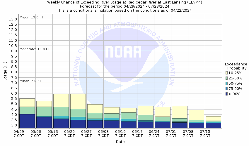
This probabilistic forecast is issued by the North Central River Forecast Center.
tab left off Hydrograph tab right off tab left off River at a Glance tab right off tab left off Download tab right off tab left on tab right on
About this graph
Forecasts for the Red Cedar River at East Lansing are issued as needed during times of high water, but are not routinely available.
Return to Area Map

Upstream Gauge - near Williamston Upstream Gauge
Zoom Level:16
Flood Categories (in feet)
Major Flood Stage: 13
Moderate Flood Stage: 10
Flood Stage: 7
Action Stage: 6
Low Stage (in feet): -9999

Historic Crests
(1) 13.40 ft on 03/24/1904
(2) 11.95 ft on 04/20/1975
(3) 11.58 ft on 04/07/1947
(4) 10.70 ft on 03/15/1918
(5) 10.47 ft on 03/20/1948
Show More Historic Crests

(P): Preliminary values subject to further review.

Recent Crests
(1) 7.18 ft on 08/13/2021
(2) 8.99 ft on 05/20/2020
(3) 7.80 ft on 01/14/2020
(4) 5.83 ft on 03/16/2019
(5) 10.28 ft on 02/22/2018
Show More Recent Crests

(P): Preliminary values subject to further review.

Low Water Records
(1) 2.91 ft on 05/17/2000
(2) 3.00 ft on 07/31/1931
(3) 3.03 ft on 08/11/1964
KML Image
Gauge LocationGauge Map Marker
Disclaimer
Latitude/Longitude Disclaimer: The gauge location shown in the above map is the approximate location based on the latitude/longitude coordinates provided to the NWS by the gauge owner.
Flood Impacts & Photos Collapse
If you notice any errors in the below information, please contact our Webmaster
13 Expect major widespread flooding of homes and businesses in area around the mouth of the Red Cedar along Sprint, Hazel, Elm, South, Clear, River, Cedar, and Beech Streets. Apartments flooded on South Washington and East Main Street. Kellogg Center, Armstrong Hall, Bailey Hall, Van Hoosen Hall, Chapel, Emmons Hall, and University Village impacted by high water.
12 Expect moderate flooding of Jenison Fieldhouse, Intramural Sports Circle, Demonstration Hall on the Michigan State University campus. University Village begins to be impacted by flood waters.
11.5 Expect moderate widespread flooding of homes and businesses in the Kalamazoo and Clippert Street, South Street, and Cedar and Beech Street areas of Lansing.
10.5 Expect moderate flooding of homes and businesses in the Cedar and Beech Streets area, South Street, and 1.5 miles downstream of gage site.
10 Jenison Fieldhouse, Intramural Sports Circle, Demonstration Hall on the Michigan State University campus impacted by flood water.
9 Jenison Fieldhouse and Intramural Sports Circle on the Michigan State University begin to get impacted by flood water.
8.5 Minor flooding of farmland, Michigan State University athletic fields, and secondary roads.
8 Expect minor flooding of the Michigan State University athletic fields. The Potter Park Zoo parking lot in Lansing begins to flood.
7 Expect minor flooding of low lying areas, adjacent parks, and farmland.
6 River reaches bankfull and low lying areas flood.
Photos
(1) Red Cedar River at East Lansing - Looking Downstream
(2) USGS Gaging Station on the Red Cedar River
(3) Inside the USGS Gaging Station on the Red Cedar River
(4) USGS Staff Gage
(5) USGS Staff Gage
(6) Red Cedar River at East Lansing - Looking Upstream
(7) Flooding of Kobs field and softball field at MSU
(8) Flooding of Red Cedar Golf Course near MSU
(9) 2004 High water resulted in sandbagging near Potter Zoo
(10) 2004 Flooding along the Red Cedar River near the Potter Zoo
(11) 2004 Flooding of Linbergh Dr. along the Red Cedar River
(12) 2004 High Water on the Red Cedar River near Pennsylvania Ave

Other Real-time and/or Archive Data Sources:

Additional Information Collapse
How low could the river get?
USGS Streamflow Duration Hydrographs
Collaborative Agencies Collapse
The National Weather Service prepares its forecasts and other services in collaboration with agencies like the US Geological Survey, US Bureau of Reclamation, US Army Corps of Engineers, Natural Resource Conservation Service, National Park Service, ALERT Users Group, Bureau of Indian Affairs, and many state and local emergency managers across the country. For details, please click here.
NWS Information
National Weather Service
Grand Rapids Weather Forecast Office
4899 Tim Dougherty Drive SE
Grand Rapids, MI 49512-4034
(616) 949-0643
Ask Questions/Webmaster
Page last modified: 2-Nov-2020 7:30 PM
Disclaimer
Credits
Glossary
Privacy Policy
About Us
Career Opportunities