Skip Navigation Link weather.gov  
NOAA logo - Click to go to the NOAA homepage National Weather Service NWS logo - Click to go to the NWS homepage
Advanced Hydrologic Prediction Service
Image background of Navigation bar Left
Navigation Bar End Cap


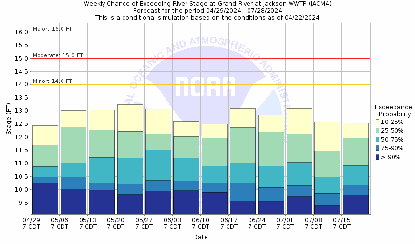
This probabilistic forecast is issued by the North Central River Forecast Center.
tab left off Hydrograph tab right off tab left off River at a Glance tab right off tab left off Download tab right off tab left on tab right on
About this graph
Forecasts for the Grand River at Jackson are issued as needed during times of high water, but are not routinely available.
Return to Area Map

Downstream Gauge Downstream Gauge - at Eaton Rapids
Zoom Level:16
Flood Categories (in feet)
Major Flood Stage: 16
Moderate Flood Stage: 15
Flood Stage: 14
Action Stage: 13
Low Flow (in CFS): -9999

Historic Crests
(1) 15.44 ft on 06/25/1968
(2) 15.20 ft on 08/17/1995
(3) 15.12 ft on 08/16/2016
(4) 14.81 ft on 08/12/2021
(5) 14.77 ft on 10/09/2021 (P)
Show More Historic Crests

(P): Preliminary values subject to further review.

Recent Crests
(1) 14.77 ft on 10/09/2021 (P)
(2) 14.81 ft on 08/12/2021
(3) 14.35 ft on 05/18/2020
(4) 13.25 ft on 06/05/2019
(5) 14.59 ft on 09/01/2018
Show More Recent Crests

(P): Preliminary values subject to further review.

Low Water Records
(1) 8.00 ft on 08/22/1936
KML Image
Gauge LocationGauge Map Marker
Disclaimer
Latitude/Longitude Disclaimer: The gauge location shown in the above map is the approximate location based on the latitude/longitude coordinates provided to the NWS by the gauge owner.
Flood Impacts & Photos Collapse
If you notice any errors in the below information, please contact our Webmaster
16.5 Expect widespread street flooding, impassable roads and flooded basements. Expect major flooding of the industrial area downtown and businesses and residences along West Trail Street in an area east of Grand River Bridge, Lewis Street, High Street, and Losey Street.
16 Expect major flooding of residences along West Trail Street, Lewis Street, High Street, Losey Street and in areas east of Grand River Bridge. Railroad tracks inundated in low lying areas along river.
15 Expect moderate flooding of residences along High Street, Lewis Street, and Losey Street. High water would disrupt traffic and damage residences.
14 Expect minor flooding of low lying areas.
13 River is bankfull. River begins to flow into low lying areas.
Photos
(1) Grand River at Jackson - Looking Downstream
(2) Inside USGS Gaging Station
(3) USGS Gaging Station on the Grand River at Jackson
(4) Grand River at Jackson - Looking Upstream

Other Real-time and/or Archive Data Sources:

Additional Information Collapse
How low could the river get?
USGS Streamflow Duration Hydrographs
Collaborative Agencies Collapse
The National Weather Service prepares its forecasts and other services in collaboration with agencies like the US Geological Survey, US Bureau of Reclamation, US Army Corps of Engineers, Natural Resource Conservation Service, National Park Service, ALERT Users Group, Bureau of Indian Affairs, and many state and local emergency managers across the country. For details, please click here.
NWS Information
National Weather Service
Grand Rapids Weather Forecast Office
4899 Tim Dougherty Drive SE
Grand Rapids, MI 49512-4034
(616) 949-0643
Ask Questions/Webmaster
Page last modified: 2-Nov-2020 7:30 PM
Disclaimer
Credits
Glossary
Privacy Policy
About Us
Career Opportunities