Skip Navigation Link weather.gov  
NOAA logo - Click to go to the NOAA homepage National Weather Service NWS logo - Click to go to the NWS homepage
Advanced Hydrologic Prediction Service
Image background of Navigation bar Left
Navigation Bar End Cap


This probabilistic forecast is issued by the West Gulf River Forecast Center.
tab left off Hydrograph tab right off tab left off River at a Glance tab right off tab left off Download tab right off tab left on tab right on
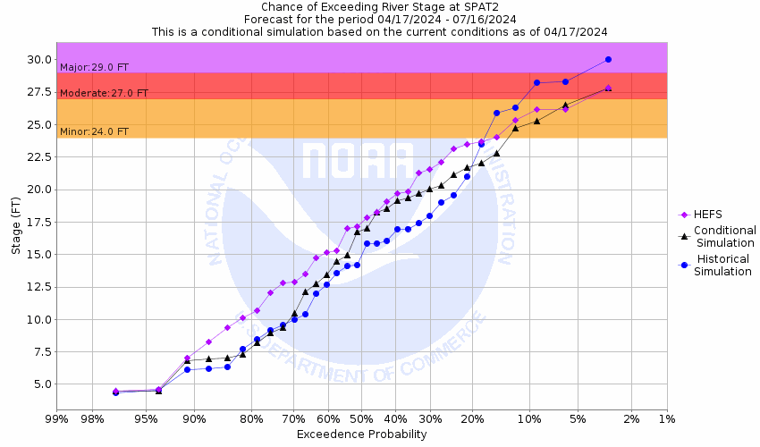
About this graph
Forecasts for the Navidad River near Speaks are issued as needed during times of high water, but are not routinely available.
Return to Area Map

Upstream Gauge - at Sublime Upstream Gauge Downstream Gauge Downstream Gauge - near Morales
Zoom Level:16
Flood Categories (in feet)
Major Flood Stage: 29
Moderate Flood Stage: 27
Flood Stage: 24
Action Stage: 21
Low Stage (in feet): -9999

Historic Crests
(1) 32.79 ft on 08/29/2017
(2) 30.24 ft on 10/18/1998
(3) 28.20 ft on 04/19/2009
(4) 27.89 ft on 05/14/1982
(5) 27.75 ft on 06/17/2015
Show More Historic Crests

(P): Preliminary values subject to further review.

Recent Crests
(1) 24.87 ft on 07/10/2021 (P)
(2) 23.89 ft on 12/09/2018
(3) 32.79 ft on 08/29/2017
(4) 27.73 ft on 04/20/2016
(5) 27.75 ft on 06/17/2015
Show More Recent Crests

(P): Preliminary values subject to further review.

Low Water Records
Currently none available.
KML Image
Gauge LocationGauge Map Marker
Disclaimer
Latitude/Longitude Disclaimer: The gauge location shown in the above map is the approximate location based on the latitude/longitude coordinates provided to the NWS by the gauge owner.
Flood Impacts & Photos Collapse
If you notice any errors in the below information, please contact our Webmaster
33 Disastrous flooding occurs with the lowest homes upstream near Vienna and in the lower part of Lavaca and northern parts of Jackson counties flooded. Flow is over one mile wide in much of the floodplain and numerous roads and bridges are impassable. Hundreds of head of livestock are cut off and can drown.
29 Major lowland flooding continues with the river close to one miles wide near Speaks and FM 530 cutting off large areas of the floodplain. Several roads and bridges near the river are inundated and impassable. Homes in low areas of the floodplain upstream near Vienna and in the lowwer part of Lavaca County are threatened. Hundereds of head of livestock are threatened.
28 Major lowland flooding begins with the river several hundred yards wide in the vicinity of the gauge. Approaches to the FM 530 bridge are flooded and impassable. Much of the floodplain is cut off endangering livestock.
27 Moderate lowland flooding begins with the approaches to the FM 530 bridge inundated and the gage cut off. large areas of the floodplain are cut off potentially isolated and drowning cattle.
24 Minor lowland flooding begins with the river one hundred yards wide in the vicinity of the gauge. The approaches to the FM 530 bridge are flooded.
21 Flow exceeds the lowest sections of both banks.

Other Real-time and/or Archive Data Sources:

Collaborative Agencies Collapse
The National Weather Service prepares its forecasts and other services in collaboration with agencies like the US Geological Survey, US Bureau of Reclamation, US Army Corps of Engineers, Natural Resource Conservation Service, National Park Service, ALERT Users Group, Bureau of Indian Affairs, and many state and local emergency managers across the country. For details, please click here.
NWS Information
National Weather Service
Houston/Galveston Weather Forecast Office
1353 FM 646, Suite 202
Dickinson, TX 77539
(281) 337-5074
Ask Questions/Webmaster
Page last modified: 2-Nov-2020 7:29 PM
Disclaimer
Credits
Glossary
Privacy Policy
About Us
Career Opportunities