Skip Navigation Link weather.gov  
NOAA logo - Click to go to the NOAA homepage National Weather Service NWS logo - Click to go to the NWS homepage
Advanced Hydrologic Prediction Service
Image background of Navigation bar Left
Navigation Bar End Cap


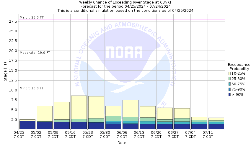
This probabilistic forecast is issued by the Arkansas Red-Basin River Forecast Center.
tab left off Hydrograph tab right off tab left off River at a Glance tab right off tab left off Download tab right off tab left on tab right on
About this graph
Forecasts for the Chikaskia River near Corbin are issued as needed during times of high water, but are not routinely available.

Vertical Datum updated from NGVD29 to NAVD88 by gauge owner.

Return to Area Map

Downstream Gauge Downstream Gauge - near Blackwell
Zoom Level:13
Flood Categories (in feet)
Major Flood Stage: 28
Moderate Flood Stage: 19
Flood Stage: 10
Action Stage: 8
Low Stage (in feet): -9999

Historic Crests
(1) 28.00 ft on 06/09/1923
(2) 22.90 ft on 11/01/1998
(3) 22.75 ft on 10/11/1985
(4) 22.60 ft on 10/10/1985
(5) 22.50 ft on 05/17/1951
Show More Historic Crests

(P): Preliminary values subject to further review.

Recent Crests
(1) 9.70 ft on 07/08/2023 (P)
(2) 10.01 ft on 06/02/2022
(3) 13.50 ft on 05/25/2022
(4) 12.32 ft on 03/23/2021
(5) 11.05 ft on 03/18/2021
Show More Recent Crests

(P): Preliminary values subject to further review.

Low Water Records
(1) 1.57 ft on 08/01/2003
Show More Low Water Records
KML Image
Gauge LocationGauge Map Marker
Disclaimer
Latitude/Longitude Disclaimer: The gauge location shown in the above map is the approximate location based on the latitude/longitude coordinates provided to the NWS by the gauge owner.
Flood Impacts & Photos Collapse
If you notice any errors in the below information, please contact our Webmaster
29.85 The Highway 49 River Bridge at gaging site would begin to take on water.
28 Major and widespread flooding is anticipated over farmland. A section of Highway 49 north of the river gage site may begin to take on water. Flood waters begin to encroach on homestead grounds northeast of the gage site.
19 Widespread flooding of low-lying areas and agricultural areas can be expected especially downstream.
13 Left bank overflows extend out to about 100 yards. A low water bridge on South Sumner Road, 3 miles downstream from gage site or 2 miles southwest of Corbin, floods.
10 Flooding of low-lying areas can be expected, especially along the right bank.
7 The left bank overflow begins with no serious flooding.
Photos
(1) Looking upstream, stage 2.42 ft - autumn
(2) Looking downstream, stage 2.42 ft -autumn
(3) looking south at wireweight gage on bridge and DCP gage house
(4) Looking north on Hwy 49 Bridge over river

Other Real-time and/or Archive Data Sources:

Collaborative Agencies Collapse
The National Weather Service prepares its forecasts and other services in collaboration with agencies like the US Geological Survey, US Bureau of Reclamation, US Army Corps of Engineers, Natural Resource Conservation Service, National Park Service, ALERT Users Group, Bureau of Indian Affairs, and many state and local emergency managers across the country. For details, please click here.
NWS Information
National Weather Service
Wichita Weather Forecast Office
2142 South Tyler Road
Wichita, KS 67209
(316) 942-3102
Ask Questions/Webmaster
Page last modified: 2-Nov-2020 7:29 PM
Disclaimer
Credits
Glossary
Privacy Policy
About Us
Career Opportunities