Skip Navigation Link weather.gov  
NOAA logo - Click to go to the NOAA homepage National Weather Service NWS logo - Click to go to the NWS homepage
Advanced Hydrologic Prediction Service
Image background of Navigation bar Left
Navigation Bar End Cap


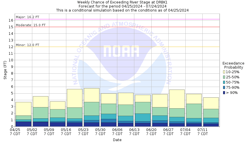
This probabilistic forecast is issued by the Arkansas Red-Basin River Forecast Center.
tab left off Hydrograph tab right off tab left off River at a Glance tab right off tab left off Download tab right off tab left on tab right on
About this graph
Forecasts for the Arkansas River at Derby are issued as needed during times of high water, but are not routinely available.

Vertical Datum updated from NGVD29 to NAVD88 by gauge owner.

Return to Area Map

Upstream Gauge - near Haven Upstream Gauge Downstream Gauge Downstream Gauge - near Mulvane
Zoom Level:16
Flood Categories (in feet)
Major Flood Stage: 16.2
Moderate Flood Stage: 15
Flood Stage: 12
Action Stage: 10
Low Stage (in feet): -9999

Historic Crests
(1) 16.60 ft on 11/02/1998
(2) 16.19 ft on 07/15/1993
(3) 16.08 ft on 05/09/1993
(4) 15.87 ft on 11/01/1979
(5) 15.53 ft on 05/25/2019
Show More Historic Crests

(P): Preliminary values subject to further review.

Recent Crests
(1) 11.13 ft on 06/01/2022
(2) 7.43 ft on 06/27/2021
(3) 5.93 ft on 05/16/2020
(4) 12.41 ft on 06/24/2019
(5) 15.53 ft on 05/25/2019
Show More Recent Crests

(P): Preliminary values subject to further review.

Low Water Records
(1) 1.18 ft on 07/25/2012
(2) 1.20 ft on 07/22/2011
Show More Low Water Records
KML Image
Gauge LocationGauge Map Marker
Disclaimer
Latitude/Longitude Disclaimer: The gauge location shown in the above map is the approximate location based on the latitude/longitude coordinates provided to the NWS by the gauge owner.
Flood Impacts & Photos Collapse
If you notice any errors in the below information, please contact our Webmaster
23.5 Top of levee system.
17.5 Flood waters spread more over the east bank along with vast flooding of agricultural fields.
16.2 Widespread flooding of low-lying areas and agricultural areas will result. Residents south of Tucker Lane may see flood waters impacting homes.
15.5 Tucker Lane on the downstream west bank of the river will be covered with 1 foot of water. Homes south of Tucker Lane begin to experience minor basement flooding. More agricultural fields will be flooded.
15 Flooding of agricultural areas will occur. Flood waters begin to flow across Washington Street on the west side of the river bridge and over Tucker Lane on the downstream right bank of river.
12 The river will be out of its main channel and expand to a width near 600 feet wide. Expect flooding of low lying areas around the river. The Derby Park facility on the downstream east bank of the Market St bridge is inundated.
11.6 The river starts to overflow its banks.
Photos
(1) Upstream
(2) Downstream
(3) Looking southwest at DCP gage house
(4) Looking west at wireweight across Market St bridge over river

Other Real-time and/or Archive Data Sources:

Collaborative Agencies Collapse
The National Weather Service prepares its forecasts and other services in collaboration with agencies like the US Geological Survey, US Bureau of Reclamation, US Army Corps of Engineers, Natural Resource Conservation Service, National Park Service, ALERT Users Group, Bureau of Indian Affairs, and many state and local emergency managers across the country. For details, please click here.
NWS Information
National Weather Service
Wichita Weather Forecast Office
2142 South Tyler Road
Wichita, KS 67209
(316) 942-3102
Ask Questions/Webmaster
Page last modified: 2-Nov-2020 7:29 PM
Disclaimer
Credits
Glossary
Privacy Policy
About Us
Career Opportunities