Skip Navigation Link weather.gov  
NOAA logo - Click to go to the NOAA homepage National Weather Service NWS logo - Click to go to the NWS homepage
Advanced Hydrologic Prediction Service
Image background of Navigation bar Left
Navigation Bar End Cap


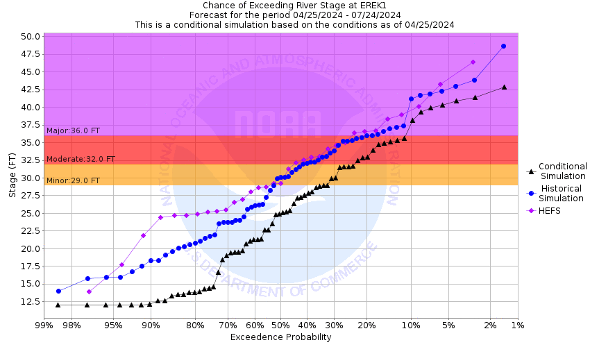
This probabilistic forecast is issued by the Arkansas Red-Basin River Forecast Center.
tab left off Hydrograph tab right off tab left off River at a Glance tab right off tab left off Download tab right off tab left on tab right on
About this graph
Forecasts for the Neosho River near Erie are issued as needed during times of high water, but are not routinely available.

Vertical Datum updated from NGVD29 to NAVD88 by gauge owner.

Return to Area Map

Upstream Gauge - near Chanute Upstream Gauge Downstream Gauge Downstream Gauge - near Parsons
Zoom Level:14
Flood Categories (in feet)
Major Flood Stage: 36
Moderate Flood Stage: 32
Flood Stage: 29
Action Stage: 27
Low Stage (in feet): -9999

Historic Crests
(1) 40.60 ft on 07/02/2007
(2) 39.10 ft on 05/27/2019
(3) 36.96 ft on 11/05/1998
(4) 36.66 ft on 10/11/2018
(5) 35.00 ft on 09/12/2009
(6) 34.65 ft on 04/30/2009
Show More Historic Crests

(P): Preliminary values subject to further review.

Recent Crests
(1) 33.30 ft on 06/02/2022
(2) 32.28 ft on 05/07/2022
(3) 34.35 ft on 06/27/2021
(4) 31.82 ft on 03/19/2021
(5) 30.09 ft on 03/13/2021
(6) 30.72 ft on 08/12/2019
Show More Recent Crests

(P): Preliminary values subject to further review.

Low Water Records
Currently none available.
KML Image
Gauge LocationGauge Map Marker
Disclaimer
Latitude/Longitude Disclaimer: The gauge location shown in the above map is the approximate location based on the latitude/longitude coordinates provided to the NWS by the gauge owner.
Flood Impacts & Photos Collapse
If you notice any errors in the below information, please contact our Webmaster
40 There is a high possibility that many parts of the levee will be breached. Extensive flooding covers Highway 59 from Erie to the river bridge then again south of the river bridge. Farmlands become inundated. Major flooding occurs on the west side of Erie. From 1 block east of Highway 59 in town between 4th Street to just north of State Street, roads flood and approximately 10 homes and 5 businesses take on 4 feet of water.
39 Parts of the levee system overtops and there is a possible breach of the levee system.
37.5 Parts of the levee system overtops.
36 The intersection of Main Street and just south of 7th Street becomes flooded to a depth of near 10 inches for a distance of 10 to 15 yards.
33 The road 7 miles northwest of Erie at 190th Road just west of Big Creek becomes flooded.
29 Expect flooding of lowlands along the vicinity of the river.
28 The road at 160th Street that is 4 miles northwest of Erie, next to the river, may take on water.
Photos
(1) Looking upstream
(2) Looking downstream
(3) Looking downstream under bridge view
(4) Looking southwest at 3 staff gages
(5) Staff gage bent over due to break in levee at that point. On 7/2/07 stage 38 ft.
(6) Flooding at Hwy 59 and 110th Rd on July 2, 2007.

Other Real-time and/or Archive Data Sources:

Collaborative Agencies Collapse
The National Weather Service prepares its forecasts and other services in collaboration with agencies like the US Geological Survey, US Bureau of Reclamation, US Army Corps of Engineers, Natural Resource Conservation Service, National Park Service, ALERT Users Group, Bureau of Indian Affairs, and many state and local emergency managers across the country. For details, please click here.
NWS Information
National Weather Service
Wichita Weather Forecast Office
2142 South Tyler Road
Wichita, KS 67209
(316) 942-3102
Ask Questions/Webmaster
Page last modified: 2-Nov-2020 7:29 PM
Disclaimer
Credits
Glossary
Privacy Policy
About Us
Career Opportunities