Skip Navigation Link weather.gov  
NOAA logo - Click to go to the NOAA homepage National Weather Service NWS logo - Click to go to the NWS homepage
Advanced Hydrologic Prediction Service
Image background of Navigation bar Left
Navigation Bar End Cap


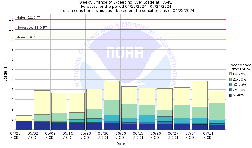
This probabilistic forecast is issued by the Arkansas Red-Basin River Forecast Center.
tab left off Hydrograph tab right off tab left off River at a Glance tab right off tab left off Download tab right off tab left on tab right on
About this graph
Forecasts for the Arkansas River near Haven are issued as needed during times of high water, but are not routinely available.

Vertical Datum updated from NGVD29 to NAVD88 by gauge owner.

Return to Area Map

Upstream Gauge - at Hutchinson Upstream Gauge Downstream Gauge Downstream Gauge - at Derby
Zoom Level:15
Flood Categories (in feet)
Major Flood Stage: 12
Moderate Flood Stage: 11
Flood Stage: 10
Action Stage: 8
Low Stage (in feet): -9999

Historic Crests
(1) 13.08 ft on 05/08/2007
(2) 12.99 ft on 05/10/2019
(3) 12.96 ft on 10/12/2018
(4) 12.95 ft on 09/28/1973
(5) 12.81 ft on 05/22/2019
Show More Historic Crests

(P): Preliminary values subject to further review.

Recent Crests
(1) 5.06 ft on 02/28/2020
(2) 12.51 ft on 05/29/2019
(3) 12.81 ft on 05/22/2019
(4) 12.99 ft on 05/10/2019
(5) 10.66 ft on 05/08/2019
Show More Recent Crests

(P): Preliminary values subject to further review.

Low Water Records
(1) 0.10 ft on 02/03/1995
Show More Low Water Records
KML Image
Gauge LocationGauge Map Marker
Disclaimer
Latitude/Longitude Disclaimer: The gauge location shown in the above map is the approximate location based on the latitude/longitude coordinates provided to the NWS by the gauge owner.
Flood Impacts & Photos Collapse
If you notice any errors in the below information, please contact our Webmaster
13 Expect most of the levee system to be overtopped. Flood waters will be widespread.
12 Flooding overspreads pasture land along both banks to an extent of 30 feet. The river current will be swift with violent eddies in the middle channel. Water overtops the levee about 3 miles upstream from the gage site at Haven Road.
11 Flooding overspreads surrounding pastureland adjacent to the right bank. Expect river current to be swift with violent eddies.
10 The river begins to overflow on the right bank affecting pastureland. Expect river current to be swift with violent eddies.
9 The river will be out of its channel but within its banks. River extends to a width of about 550 feet. The channel current will be swift.
8 The river is within its banks but out of the main channel.
Photos
(1) Looking upstream, stage 3.95 ft
(2) Looking downstream, stage 3.95 ft
(3) Looking north at DCP gage house
(4) looking south at wireweight gage and DCP
(5) Looking at wireweight and old staff gage

Other Real-time and/or Archive Data Sources:

Collaborative Agencies Collapse
The National Weather Service prepares its forecasts and other services in collaboration with agencies like the US Geological Survey, US Bureau of Reclamation, US Army Corps of Engineers, Natural Resource Conservation Service, National Park Service, ALERT Users Group, Bureau of Indian Affairs, and many state and local emergency managers across the country. For details, please click here.
NWS Information
National Weather Service
Wichita Weather Forecast Office
2142 South Tyler Road
Wichita, KS 67209
(316) 942-3102
Ask Questions/Webmaster
Page last modified: 2-Nov-2020 7:29 PM
Disclaimer
Credits
Glossary
Privacy Policy
About Us
Career Opportunities