Skip Navigation Link weather.gov  
NOAA logo - Click to go to the NOAA homepage National Weather Service NWS logo - Click to go to the NWS homepage
Advanced Hydrologic Prediction Service
Image background of Navigation bar Left
Navigation Bar End Cap


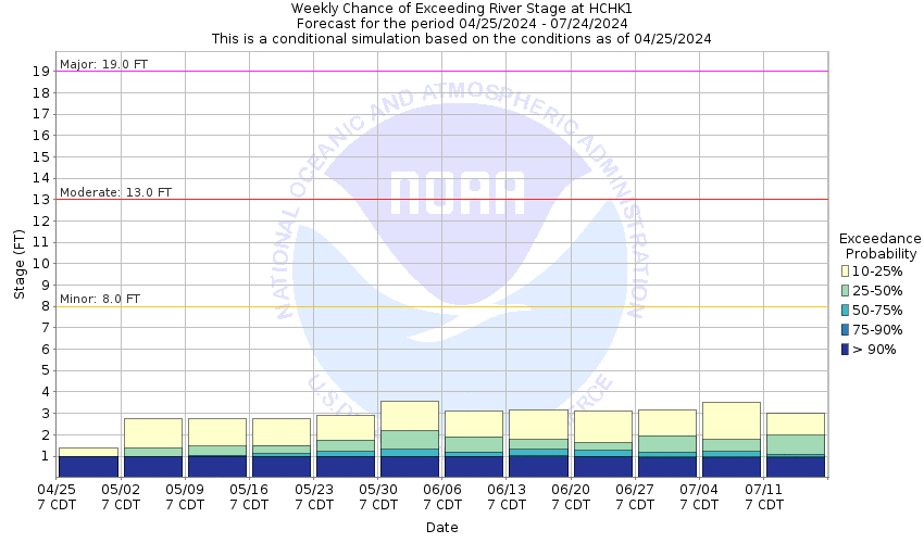
This probabilistic forecast is issued by the Arkansas Red-Basin River Forecast Center.
tab left off Hydrograph tab right off tab left off River at a Glance tab right off tab left off Download tab right off tab left on tab right on
About this graph
Forecasts for the Arkansas River at Hutchinson are issued as needed during times of high water, but are not routinely available.
Return to Area Map

Upstream Gauge - at Great Bend Upstream Gauge Downstream Gauge Downstream Gauge - near Haven
Zoom Level:16
Flood Categories (in feet)
Major Flood Stage: 19
Moderate Flood Stage: 13
Flood Stage: 8
Action Stage: 6
Low Stage (in feet): -9999

Historic Crests
(1) 13.85 ft on 04/02/1973
(2) 13.10 ft on 09/27/1973
(3) 12.70 ft on 05/08/2007
(4) 12.15 ft on 09/29/1973
(5) 10.88 ft on 10/12/2018
Show More Historic Crests

(P): Preliminary values subject to further review.

Recent Crests
(1) 9.00 ft on 06/24/2019
(2) 10.30 ft on 05/22/2019
(3) 10.86 ft on 05/10/2019
(4) 10.88 ft on 10/12/2018
(5) 8.12 ft on 08/07/2013
Show More Recent Crests

(P): Preliminary values subject to further review.

Low Water Records
Currently none available.
KML Image
Gauge LocationGauge Map Marker
Disclaimer
Latitude/Longitude Disclaimer: The gauge location shown in the above map is the approximate location based on the latitude/longitude coordinates provided to the NWS by the gauge owner.
Flood Impacts & Photos Collapse
If you notice any errors in the below information, please contact our Webmaster
19 The top of the levee in the vicinity of the gage overtops. Breach of the levee will result in widespread flooding of low-lying and agricultural areas.
14.3 Flood waters rise to the lowest base of closure on the Harsha Drainage Canal on 2nd Avenue.
13.5 Flood waters rise to the Missouri Pacific Railroad.
13 Closure of the Harsha Drainage Canal on 2nd Avenue commences on the right bank. Other closures begin on the the Missouri Pacific Railroad and 11th Street.
12.7 The intersection between Yoder and Eales Road becomes flooded.
10 Expect minor flooding of Carey Park, more so after a few days of ground water seepage.
8 Minor flooding of low-lying areas and bottom land can be expected. Channel flow will be swift.
6 The river is out of its main channel. The width of the river will expand to 550 feet. The channel flow will be swift.
Photos
(1) Upstream
(2) Downstream
(3) Looking southwest at wireweight gage
(4) Looking northeast
Collaborative Agencies Collapse
The National Weather Service prepares its forecasts and other services in collaboration with agencies like the US Geological Survey, US Bureau of Reclamation, US Army Corps of Engineers, Natural Resource Conservation Service, National Park Service, ALERT Users Group, Bureau of Indian Affairs, and many state and local emergency managers across the country. For details, please click here.
NWS Information
National Weather Service
Wichita Weather Forecast Office
2142 South Tyler Road
Wichita, KS 67209
(316) 942-3102
Ask Questions/Webmaster
Page last modified: 2-Nov-2020 7:29 PM
Disclaimer
Credits
Glossary
Privacy Policy
About Us
Career Opportunities