Skip Navigation Link weather.gov  
NOAA logo - Click to go to the NOAA homepage National Weather Service NWS logo - Click to go to the NWS homepage
Advanced Hydrologic Prediction Service
Image background of Navigation bar Left
Navigation Bar End Cap


This probabilistic forecast is issued by the Arkansas Red-Basin River Forecast Center.
tab left off Hydrograph tab right off tab left off River at a Glance tab right off tab left off Download tab right off tab left on tab right on
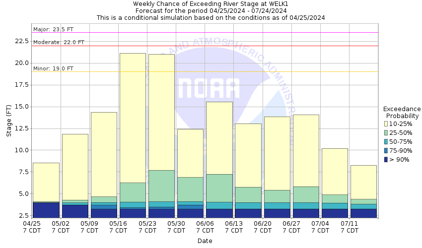
About this graph
Forecasts for the Slate Creek (KS) at Wellington are issued as needed during times of high water, but are not routinely available.

Vertical Datum updated from NGVD29 to NAVD88 by gauge owner.

Return to Area Map

Zoom Level:15
Flood Categories (in feet)
Major Flood Stage: 23.5
Moderate Flood Stage: 22
Flood Stage: 19
Action Stage: 17
Low Stage (in feet): -9999

Historic Crests
(1) 26.06 ft on 05/08/2019
(2) 25.82 ft on 06/17/1975
(3) 24.28 ft on 09/13/2008
(4) 23.80 ft on 07/02/1976
(5) 23.80 ft on 04/27/2009
(6) 23.70 ft on 11/01/1998
Show More Historic Crests

(P): Preliminary values subject to further review.

Recent Crests
(1) 21.67 ft on 05/25/2022 (P)
(2) 20.89 ft on 03/23/2021
(3) 21.44 ft on 03/18/2021
(4) 18.72 ft on 10/30/2020
(5) 21.02 ft on 10/04/2019
(6) 20.04 ft on 08/26/2019
(7) 21.39 ft on 06/24/2019
(8) 19.53 ft on 06/19/2019
(9) 22.27 ft on 05/27/2019
(10) 21.14 ft on 05/25/2019
Show More Recent Crests

(P): Preliminary values subject to further review.

Low Water Records
Currently none available.
KML Image
Gauge LocationGauge Map Marker
Disclaimer
Latitude/Longitude Disclaimer: The gauge location shown in the above map is the approximate location based on the latitude/longitude coordinates provided to the NWS by the gauge owner.
Flood Impacts & Photos Collapse
If you notice any errors in the below information, please contact our Webmaster
25.7 Water begins to flow across Highway 81 just to the north of the river bridge located south of town. Cropland and field flooding will be more expansive. The creek will swell to around 3/4 of a mile wide in areas. Slate Creek flood waters will pour over the Kansas Turnpike and inundate about a quarter mile of the road around 4 miles south of the Wellington exit.
23.5 Slate Creek floods the Kansas Turnpike near mile marker 15 or four miles south of the Wellington exit. Closing of I-35 or the Kansas Turnpike from the Wellington interchange to the KS OK border is highly likely and traffic to be rerouted. Expect extensive cropland and field flooding along the creek.
22 The Kansas Turnpike may begin to take on water between mile marker 14 and 15 near the vicinity of Slate Creek. Road closure may be possible near this section of the Kansas Turnpike if the creek continues to rise.
20 Flood waters cover several low lying spots along Seneca Road between 40th and 60th Street just southeast of Wellington. Woods Park within the city floods. Slate Creek comes to roadway's edge at mile marker 15 on the the Kansas Turnpike.
19 Flood waters begin to over flow the banks. Minor low land flooding can be expected along the creek.
Photos
(1) Looking upstream
(2) Looking downstream
(3) Looking north across Hwy 81 Bridge over Slate Creek
(4) Looking south across Hwy 81 Bridge over Slate Creek
(5) Looking at USGS gage house
(6) Looking north at wire-weight gage.

Other Real-time and/or Archive Data Sources:

Collaborative Agencies Collapse
The National Weather Service prepares its forecasts and other services in collaboration with agencies like the US Geological Survey, US Bureau of Reclamation, US Army Corps of Engineers, Natural Resource Conservation Service, National Park Service, ALERT Users Group, Bureau of Indian Affairs, and many state and local emergency managers across the country. For details, please click here.
NWS Information
National Weather Service
Wichita Weather Forecast Office
2142 South Tyler Road
Wichita, KS 67209
(316) 942-3102
Ask Questions/Webmaster
Page last modified: 2-Nov-2020 7:29 PM
Disclaimer
Credits
Glossary
Privacy Policy
About Us
Career Opportunities