Skip Navigation Link weather.gov  
NOAA logo - Click to go to the NOAA homepage National Weather Service NWS logo - Click to go to the NWS homepage
Advanced Hydrologic Prediction Service
Image background of Navigation bar Left
Navigation Bar End Cap


This probabilistic forecast is issued by the Ohio River Forecast Center.
tab left off Hydrograph tab right off tab left off River at a Glance tab right off tab left off Download tab right off tab left on tab right on
About this graph
Forecasts for the Big Darby Creek at Darbyville are issued as needed during times of high water, but are not routinely available.
Return to Area Map

Zoom Level:14
Flood Categories (in feet)
Major Flood Stage: 20
Moderate Flood Stage: 17
Flood Stage: 12
Action Stage: 10
Low Stage (in feet): -9999

Historic Crests
(1) 17.94 ft on 01/22/1959
(2) 15.90 ft on 02/27/1929
(3) 15.62 ft on 06/03/1997
(4) 15.30 ft on 01/07/2005
(5) 15.07 ft on 02/25/1975
(6) 14.77 ft on 06/29/1998
(7) 14.70 ft on 01/27/1952
(8) 14.31 ft on 03/11/1964
(9) 14.00 ft on 09/15/1979
(10) 13.92 ft on 03/06/1963
Show More Historic Crests

(P): Preliminary values subject to further review.

Recent Crests
(1) 13.40 ft on 03/21/2020 (P)
(2) 12.03 ft on 05/19/2019
(3) 11.20 ft on 02/08/2019
(4) 10.46 ft on 11/03/2018
(5) 10.97 ft on 06/24/2018
(6) 13.32 ft on 04/05/2018
(7) 12.40 ft on 02/26/2018
(8) 10.78 ft on 02/17/2018
(9) 10.10 ft on 11/21/2017
(10) 11.53 ft on 11/07/2017
Show More Recent Crests

(P): Preliminary values subject to further review.

Low Water Records
(1) 1.40 ft on 09/17/1932
(2) 1.53 ft on 08/27/2012
(3) 1.60 ft on 09/28/2016
(4) 1.68 ft on 09/10/2013
(5) 1.71 ft on 08/11/2016
Show More Low Water Records
KML Image
Gauge LocationGauge Map Marker
Disclaimer
Latitude/Longitude Disclaimer: The gauge location shown in the above map is the approximate location based on the latitude/longitude coordinates provided to the NWS by the gauge owner.
Flood Impacts & Photos Collapse
If you notice any errors in the below information, please contact our Webmaster
18 This is similar to the FEMA 1 percent flood and will exceed the flood of record of January 1959. Widespread lowland flooding occurs along Darby Creek from near Darbydale to near Orient downstream through areas near Darbyville and the creek valley in Pickaway County. Portions of Darby Creek Road and Route 762 near Orient are under water. Also, State Route 104 and McLean Mill Road may be restricted near Big Darby Creek.
15 Widespread flooding of low-lying roads occurs along Big Darby Creek in Franklin, Madison and Pickaway Counties. Numerous low-lying roads become flooded from near Georgesville to Darbydale to Darbyville to Circleville.
14 Flooding occurs near the Old Shady Acres Mobile Home Park near Circleville. Lowland flooding can be expected along Big Darby Creek from near Orient downstream through Pickaway County. Portions of Darby Creek Road are flooded, as well as some water rising onto Route 762 west of Orient.
12 Lowland flooding occurs along Big Darby Creek in Pickaway, Franklin and Madison Counties. Portions of Darby Creek Road north of Darbyville become flooded.

Other Real-time and/or Archive Data Sources:

Additional Information Collapse
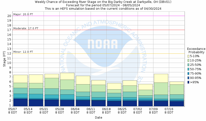
Potential River Levels - Used to
Potential River Levels
Used to Estimate the Chance of Flooding and the Range of Possible River Levels
10 Day (HEFS) 10 Day (NAEFS) River Forecast VS. River Potential
HEFS Ensemble NAEFS Ensemble Outlook vs. Forecast

Note: Use the official hydrograph at the top of this web page for river levels within the next 72 hours.

See the Product Description Document link for more details on the interpretation of the 10 Day graphics.

Click individual graphics to enlarge.

Collaborative Agencies Collapse
The National Weather Service prepares its forecasts and other services in collaboration with agencies like the US Geological Survey, US Bureau of Reclamation, US Army Corps of Engineers, Natural Resource Conservation Service, National Park Service, ALERT Users Group, Bureau of Indian Affairs, and many state and local emergency managers across the country. For details, please click here.
NWS Information
National Weather Service
Wilmington Weather Forecast Office
1901 South State Route 134
Wilmington, OH 45177
(937) 383-0031
Ask Questions/Webmaster
Page last modified: 2-Nov-2020 7:30 PM
Disclaimer
Credits
Glossary
Privacy Policy
About Us
Career Opportunities