Skip Navigation Link weather.gov  
NOAA logo - Click to go to the NOAA homepage National Weather Service NWS logo - Click to go to the NWS homepage
Advanced Hydrologic Prediction Service
Image background of Navigation bar Left
Navigation Bar End Cap


This probabilistic forecast is issued by the Ohio River Forecast Center.
tab left off Hydrograph tab right off tab left off River at a Glance tab right off tab left off Download tab right off tab left on tab right on
About this graph
Forecasts for the East Fork White River at Rivervale are issued routinely year-round.
Return to Area Map

Upstream Locations Upstream Gauge Downstream Gauge Downstream Gauge - near Bedford
Zoom Level:16
Flood Categories (in feet)
Major Flood Stage: 35
Moderate Flood Stage: 30
Flood Stage: 20
Action Stage: 15
Low Flow (in KCFS): 0.258

Historic Crests
(1) 47.60 ft on 03/29/1913
(2) 38.00 ft on 01/24/1937
(3) 37.84 ft on 01/09/2005
(4) 36.32 ft on 05/01/1996
(5) 35.97 ft on 05/11/1961
(6) 35.22 ft on 03/12/1964
(7) 34.87 ft on 01/25/1959
(8) 34.66 ft on 03/22/2008
(9) 34.41 ft on 06/10/2008
(10) 34.39 ft on 03/15/2006
Show More Historic Crests

(P): Preliminary values subject to further review.

Recent Crests
(1) 20.44 ft on 04/09/2023 (P)
(2) 29.21 ft on 03/29/2023 (P)
(3) 29.21 ft on 03/29/2023 (P)
(4) 26.08 ft on 03/12/2022 (P)
(5) 20.84 ft on 01/06/2022 (P)
(6) 25.07 ft on 07/22/2021 (P)
(7) 25.41 ft on 06/24/2021 (P)
(8) 25.73 ft on 03/04/2021 (P)
(9) 29.64 ft on 03/24/2020 (P)
(10) 20.85 ft on 02/16/2020 (P)
Show More Recent Crests

(P): Preliminary values subject to further review.

Low Water Records
(1) 2.40 ft on 10/14/1964
(2) 2.51 ft on 09/26/1963
(3) 3.08 ft on 09/01/2012
(4) 3.30 ft on 09/18/2013
KML Image
Gauge LocationGauge Map Marker
Disclaimer
Latitude/Longitude Disclaimer: The gauge location shown in the above map is the approximate location based on the latitude/longitude coordinates provided to the NWS by the gauge owner.
Flood Impacts & Photos Collapse
If you notice any errors in the below information, please contact our Webmaster
45 Near or a record flood is in progress. Entire county flood plain is under water. County bridge where river gage is located is underwater.
40 County bridge where river gage is located is threatened. Flood waters threaten automated river readings and gage site.
37.7 January 2005 is the highest level for the period of record of this gage site. Portions of nearly 60 county and private roads are impassable, some by several feet of water. Numerous evacuations of local river communities. Many residents of these areas must park on high ground and boat out. January 2005 flood was the highest flood for Lawrence County since January 1937.
36 Major flood is in progress. Many evacuations from residential areas in flood plain are necessary. Portions of nearly 60 county and private roads are impassable, many by several feet of water. Many local river residents must park on high ground and boat out. Extensive damage occurs to local roads.
35 Unusual flood is in progress with possibly a few local evacuations needed.
32 Some evacuations in the Fort Ritner area are necessary. Flooding of low areas in Fort Ritner is in progress. Backwater floods county roads at some distance from river.
30 Some evacuations may occur at this level from river cabins. Water surrounds but does not flood rural agricultural families. This includes the Fort Ritner, Lawrenceport, Bono and Buddha areas. River bridge cannot be seen from northside approach to site.
29.9 During the March 2008 flood, the Bedford Times reported the following roads remained closed: Peerless Road, Lawrenceport Tunnelton Road, Pumphouse Road, SR 450, Stumphole Bridge Road, Mill Creek Road, Earl Road, Dillon Road, River Road and Rager Road.
28 Extensive river flooding in progress. Residential areas near the river begin to flood. The county bridge locally known as the Buddha bypass bridge becomes inaccessible. Several local roads are flooded including Duncan Rd/Tunnelton Rd, Fort Ritner at the underpass and post office, Old Buddha Rd, Tunnelton Rd at the railroad crossing and West Sparksville Bridge Rd.
25 All county roads across or located in the East Fork White River flood plain flood. Flooding of agricultural land becomes extensive. The county road on northside of gage floods and gage may be inaccessible except by boat. Local residents in nearby river cabins must park on higher grounds.
24.99 During the late March 2008 flood, the Bedford Times reported the following county roads still under water: River Road, Bartlettsville Road by the bridge and in the bottoms, Judah-Logan Road by the bridge, the gravel part of Logan Bottoms, Donica Church Road between Logan Bottoms and the hill, Peerless Road by Mica Metals, Little Salt Creek Run, Stumphole Bridge Road near SR 450, Huron-Williams Road, Lawrenceport Road, Rivervale Road and Earl Road.
22 A few local county roads begin to flood and are impassable. These include Buddha Road south of the gage and Lawrenceport Road. All local roads across the East Fork White River are threatened by high water, and some are closed. Flooding of agricultural lands in Lawrence County is in progress.
20.5 Lawrenceport Road just east of Lawrenceport and on the south side of river begins to flood around this level. During typical floods in this area this portion of the road can be flooded by 5 to more than 10 feet of water. During the January 2005 flood this area would have been near the "bottom" of the river, underwater by nearly 17 feet. In the Great March 1913 flood, more than 25 feet of water would have covered this location.
20 Lowest agricultural lands begin to flood near Rivervale.
17.5 White River Road south of Fort Ritner may be passable by high clearance vehicles. Driving through flood waters is not recommended.
13 Lowland flooding possible in eastern Lawrence County. Portions of White River Road south of Fort Ritner may begin to flood.
10 Banks begin to overflow.
Photos
(1) View from Devils Backbone Rd Overlook March 29 2007. River reading 15.5 feet.
(2) Another view from Devils Backbone Rd Overlook March 7 2007. River reading 23.5 feet.
(3) View from Devils Backbone Rd Overlook March 7 2007. River reading 23.5 feet.
(4) View from Devils Backbone Rd Overlook March 21 2008. River stage near 34 feet. Photo by Mike Wri
(5) Another view from Devils Backbone Rd Overlook March 2008. River near 34 feet. Courtsey Mike Wright.
(6) Tunnelhill Road March 21, 2008. River stage near 34 feet. Courtsey Mike Wright.
(7) Tunnelhill Road May 22 2008. River stage 18.2 feet.
(8) May 22 2008. River Stage 18.2 feet. High water on portions of River Rd.
(9) March 7, 2007. Tunnelhill Road is open, but River Road is flooded.
(10) March 7, 2007. River Road is flooded. River reading is 23.5 feet.
(11) Tunnelhill Road flooded by several feet March 21, 2008. River near 34 feet. Courtsey Mike Wright.
(12) Northeast View from County Bridge at Rivervale during low water.
(13) Southwest View from County Bridge at Rivervale during low water.

Other Real-time and/or Archive Data Sources:

Additional Information Collapse
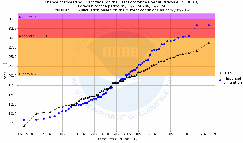
Potential River Levels - Used to
Potential River Levels
Used to Estimate the Chance of Flooding and the Range of Possible River Levels
10 Day (HEFS) 10 Day (NAEFS) 10 Day (GEFS)
HEFS Ensemble NAEFS Ensemble GEFS Ensemble

Note: Use the official hydrograph at the top of this web page for river levels within the next 72 hours.

Click individual graphics to enlarge.

Collaborative Agencies Collapse
The National Weather Service prepares its forecasts and other services in collaboration with agencies like the US Geological Survey, US Bureau of Reclamation, US Army Corps of Engineers, Natural Resource Conservation Service, National Park Service, ALERT Users Group, Bureau of Indian Affairs, and many state and local emergency managers across the country. For details, please click here.
NWS Information
National Weather Service
Indianapolis Weather Forecast Office
6900 West Hanna Ave.
Indianapolis, IN 46241
(317) 856-0360
Ask Questions/Webmaster
Page last modified: 2-Nov-2020 7:30 PM
Disclaimer
Credits
Glossary
Privacy Policy
About Us
Career Opportunities