Skip Navigation Link weather.gov  
NOAA logo - Click to go to the NOAA homepage National Weather Service NWS logo - Click to go to the NWS homepage
Advanced Hydrologic Prediction Service
Image background of Navigation bar Left
Navigation Bar End Cap


This probabilistic forecast is issued by the Ohio River Forecast Center.
tab left off Hydrograph tab right off tab left off River at a Glance tab right off tab left off Download tab right off tab left on tab right on
About this graph
Forecasts for the Tippecanoe River near Delphi are issued as needed during times of high water, but are not routinely available.
Return to Area Map

Zoom Level:16
Flood Categories (in feet)
Major Flood Stage: 15
Moderate Flood Stage: 12
Flood Stage: 8
Action Stage: 6
Low Flow (in KCFS): 0.178

Historic Crests
(1) 17.83 ft on 01/08/2008
(2) 15.48 ft on 02/21/2018
(3) 15.10 ft on 02/10/1959
(4) 14.89 ft on 02/06/2008
(5) 14.86 ft on 02/24/1985
(6) 14.72 ft on 06/10/1958
(7) 14.40 ft on 03/11/2009
(8) 14.36 ft on 02/02/1968
(9) 14.08 ft on 07/17/1957
(10) 13.85 ft on 05/15/1981
Show More Historic Crests

(P): Preliminary values subject to further review.

Recent Crests
(1) 8.04 ft on 01/26/2024 (P)
(2) 9.33 ft on 03/04/2023 (P)
(3) 8.25 ft on 02/23/2023 (P)
(4) 9.22 ft on 01/12/2020 (P)
(5) 8.61 ft on 05/01/2019
(6) 15.48 ft on 02/21/2018
(7) 7.87 ft on 11/19/2017 (P)
(8) 6.21 ft on 07/12/2017 (P)
(9) 6.25 ft on 07/01/2017 (P)
(10) 8.71 ft on 05/21/2017 (P)
Show More Recent Crests

(P): Preliminary values subject to further review.

Low Water Records
Currently none available.
KML Image
Gauge LocationGauge Map Marker
Disclaimer
Latitude/Longitude Disclaimer: The gauge location shown in the above map is the approximate location based on the latitude/longitude coordinates provided to the NWS by the gauge owner.
Flood Impacts & Photos Collapse
If you notice any errors in the below information, please contact our Webmaster
40 Probable Maximum Flood. Total devastation in Tippecanoe River flood plain. River gage, homes, and all roads, including SR 18 across the Tippecanoe River from just south of Oakdale Dam to Americus, have been swept away before this level is reached.
26.48 An unbelievable flood. Water is entirely over SR 18. The bridge might be swept away. The gaging site has been destroyed.
24.73 Water going over SR 18 by more than 2 feet. Water at the State of Indiana highway right-of-way marker located 50 feet shoreward from the gage house.
24.56 At this level flood waters would cover SR 18 by more than 2 feet.
23.45 State Road 18 is closed because of high water. Readings have stopped from gaging station. At this elevation, flood waters are just beginning to cover a USGS bronze disc located on the left upstream abutment of SR 18 bridge (northeast section of bridge near gaging station).
23 Flood waters going over SR 18. Record flooding in progress. Many homes near the Tippecanoe River are significantly damaged.
20 Flooding with serious impacts. Complete evacuation of all people in flood prone areas downstream of Oakdale Dam. Flooding closes all county roads near the river. Flood waters approach SR 18. Record flooding in progress. Some unelevated homes along Horseshoe Bend, Tippecanoe Ranch, and Tecumseh Bend Rds have more than 5 feet of water. Possible overtopping of Oakdale Dam. Homes just north of Bicycle Bridge Rd extensively flooded.
19 Record flood in progress. SR 18 bridge begins to act like a dam. Water levels are higher on the north side of the bridge than on the south side of the bridge. Must use wire weight gage to obtain river readings.
18.23 Record flooding in progress. Gage readings are no longer accurate.
17.8 All residents south of Oakdale Dam may need to evacuate. All local roads along both sides of the river are totally impassable.
17.78 Near record flood in progress. Extensive flooding of CR 1275 south of SR 18.
15 Major flooding in progress. Evacuation of many people downstream of Oakdale Dam. Roads along both sides of the river are flooded, some by more than a foot deep. Substantial property damage downstream of Oakdale Dam. Flooded areas include Horseshoe Bend, Tippecanoe Ranch and Tecumseh Bend Roads, CR 1275 W north of Bicycle Bridge Rd, extreme west end of CR 975 N and low part of Goldsberry Rd. Residents park cars on high ground. Flooding affects numerous residential and recreational areas along the river.
14 Extensive flooding in progress. County Road 1215 W flooded near TNT Pool Supply south of SR 18 in the Delphi area. Nearly all low local roads are flooded.
13 Extensive flooding in progress with some evacuations and property damage. Many low local roads near the Tippecanoe River are flooded at this level. Approaching major flood levels.
12 Significant flooding along the Tippecanoe River affecting local roads and some residential and recreational areas.
11.8 Extensive flooding along the Tippecanoe River.
10.5 Extensive lowland flooding in progress. Additional local roads begin to flood. Water levels becoming dangerous as property damage may begin and a few evacuations may be necessary.
8 Low agricultural lands, river parks and a few local roads flood along the Tippecanoe River. Oakdale Public Access Site flooded.
7.5 River approaching flood stage in the SR 18 area.
6.5 Tippecanoe River at bankfull levels downstream of Oakdale Dam in Carroll County. Most of the solidly mounted piers are underwater. A few local roads may begin to flood. During the warm season items such as lawn chairs, boats and building supplies can be swept away. Handicapped area of Oakdale Public Access site begins to flood.
6 Near bankfull conditions along the Tippecanoe River.
Photos
(1) View north from SR 18 at river level 7.4 feet.
(2) View south from SR 18 at river level 7.4 feet.
(3) West side river access at river level 7.4 feet.
(4) View facing east from SR 18 at river level at 14.3 feet
(5) View north from SR 18 at river level 14.3 feet

Other Real-time and/or Archive Data Sources:

Additional Information Collapse
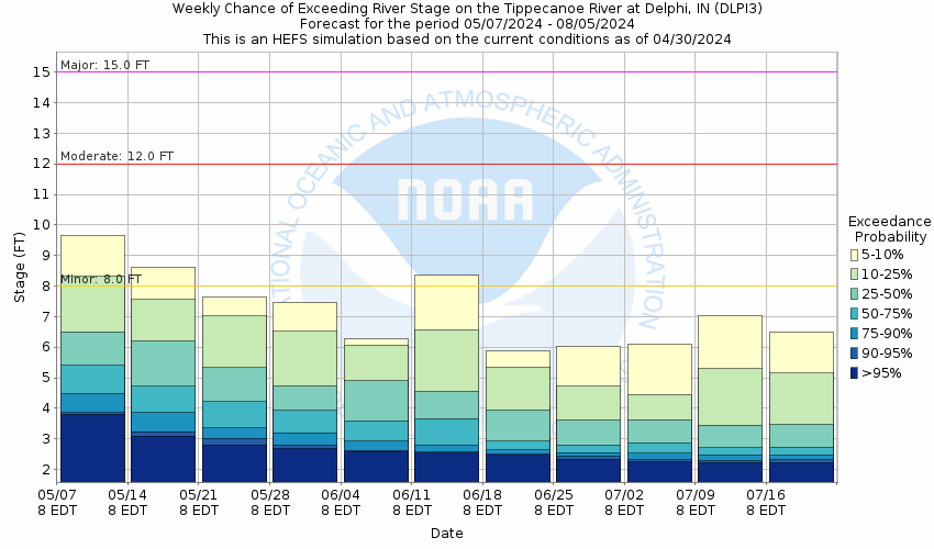
Potential River Levels - Used to
Potential River Levels
Used to Estimate the Chance of Flooding and the Range of Possible River Levels
10 Day (HEFS) 10 Day (NAEFS) 10 Day (GEFS)
HEFS Ensemble NAEFS Ensemble GEFS Ensemble

Note: Use the official hydrograph at the top of this web page for river levels within the next 72 hours.

Click individual graphics to enlarge.

Total Precipitation near Delphi
Collaborative Agencies Collapse
The National Weather Service prepares its forecasts and other services in collaboration with agencies like the US Geological Survey, US Bureau of Reclamation, US Army Corps of Engineers, Natural Resource Conservation Service, National Park Service, ALERT Users Group, Bureau of Indian Affairs, and many state and local emergency managers across the country. For details, please click here.
NWS Information
National Weather Service
Indianapolis Weather Forecast Office
6900 West Hanna Ave.
Indianapolis, IN 46241
(317) 856-0360
Ask Questions/Webmaster
Page last modified: 2-Nov-2020 7:30 PM
Disclaimer
Credits
Glossary
Privacy Policy
About Us
Career Opportunities