Skip Navigation Link weather.gov  
NOAA logo - Click to go to the NOAA homepage National Weather Service NWS logo - Click to go to the NWS homepage
Advanced Hydrologic Prediction Service
Image background of Navigation bar Left
Navigation Bar End Cap


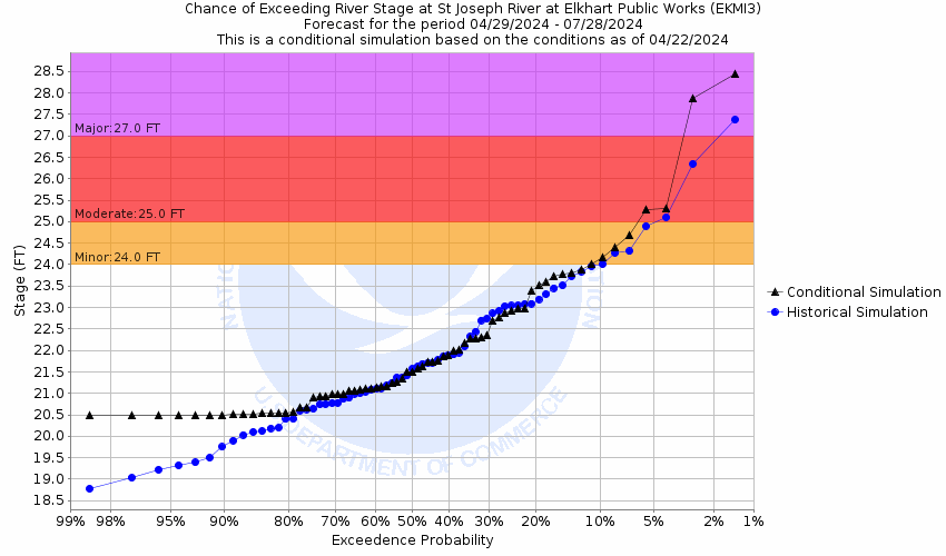
This probabilistic forecast is issued by the North Central River Forecast Center.
tab left off Hydrograph tab right off tab left off River at a Glance tab right off tab left off Download tab right off tab left on tab right on
About this graph
Forecasts for the St. Joseph River (MI/IN) at Elkhart are issued as needed during times of high water, but are not routinely available.
Return to Area Map

Upstream Locations Upstream Gauge Downstream Gauge Downstream Gauge - at South Bend
Zoom Level:16
Flood Categories (in feet)
Major Flood Stage: 27
Moderate Flood Stage: 25
Flood Stage: 24
Action Stage: 23
Low Stage (in feet): -9999

Historic Crests
(1) 30.00 ft on 03/08/1908
(2) 23.96 ft on 05/06/2019
(3) 23.17 ft on 02/27/2022
(4) 23.03 ft on 03/07/2023
(5) 22.86 ft on 04/09/2014
(6) 22.86 ft on 04/05/2014
(7) 22.86 ft on 04/05/2014
(8) 22.40 ft on 07/23/2015
(9) 22.29 ft on 04/10/2017
(10) 22.22 ft on 07/02/2021

(P): Preliminary values subject to further review.

Recent Crests
(1) 23.03 ft on 03/07/2023
(2) 23.17 ft on 02/27/2022
(3) 22.22 ft on 07/02/2021
(4) 23.96 ft on 05/06/2019
(5) 22.29 ft on 04/10/2017
(6) 22.40 ft on 07/23/2015
(7) 22.86 ft on 04/09/2014
(8) 22.86 ft on 04/05/2014
(9) 22.86 ft on 04/05/2014
(10) 30.00 ft on 03/08/1908

(P): Preliminary values subject to further review.

Low Water Records
(1) 17.05 ft on 08/05/1964
(2) 17.25 ft on 08/26/2020
(3) 17.27 ft on 06/29/2012
(4) 17.34 ft on 07/12/2016
(5) 17.44 ft on 09/15/2011
Show More Low Water Records
KML Image
Gauge LocationGauge Map Marker
Disclaimer
Latitude/Longitude Disclaimer: The gauge location shown in the above map is the approximate location based on the latitude/longitude coordinates provided to the NWS by the gauge owner.
Flood Impacts & Photos Collapse
If you notice any errors in the below information, please contact our Webmaster
30.01 Extensive flooding occurs of commercial property along east Jackson Street. Flood water is 1 to 2 feet deep in some businesses with east Jackson Street nearly impassible.
30 Residential flooding from Second Street to and including South Shore Drive. Several city streets become impassible.
29 Extensive flooding of the commercial district along east Jackson Street is in progress.
28 Extensive street flooding is in progress.
27 Water begins to affect businesses on east Jackson Street. Flooding affects a few first floor residences in the South Shore Drive area across from the hospital.
25 Basement flooding begins in residential areas of the 6th Street area and along South Shore Drive.
24 Island park in Elkhart and Kamm's Island in Mishawaka begin to flood.
Photos
(1) Downstream from gauge site
(2) Upstrean view from gauge site

Other Real-time and/or Archive Data Sources:

Additional Information Collapse
Gauge zero transitioned from 700.00ft NGVD29 to 699.55 NAVD88 on July 9, 2012. How low could the river get?
Collaborative Agencies Collapse
The National Weather Service prepares its forecasts and other services in collaboration with agencies like the US Geological Survey, US Bureau of Reclamation, US Army Corps of Engineers, Natural Resource Conservation Service, National Park Service, ALERT Users Group, Bureau of Indian Affairs, and many state and local emergency managers across the country. For details, please click here.
NWS Information
National Weather Service
Northern Indiana Weather Forecast Office
7506 E 850 N
Syracuse, IN 46567
(574) 834-1104
Ask Questions/Webmaster
Page last modified: 2-Nov-2020 7:30 PM
Disclaimer
Credits
Glossary
Privacy Policy
About Us
Career Opportunities