Skip Navigation Link weather.gov  
NOAA logo - Click to go to the NOAA homepage National Weather Service NWS logo - Click to go to the NWS homepage
Advanced Hydrologic Prediction Service
Image background of Navigation bar Left
Navigation Bar End Cap


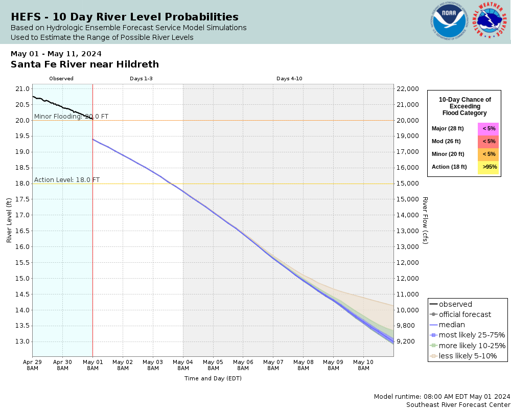
This probabilistic forecast is issued by the Southeast River Forecast Center.
tab left off Hydrograph tab right off tab left off River at a Glance tab right off tab left off Download tab right off tab left on tab right on
Experimental Short Range Forecast Uncertainty (AHPS) - External Links: Product Description Document | Customer Survey
About this graph
Forecasts for the Santa Fe River near Hildreth (in NAVD88) are issued as needed during times of high water, but are not routinely available.
Return to Area Map

Upstream Gauge - at Three Rivers Estates (in NAVD88) Upstream Gauge Downstream Gauge Downstream Gauge - at Rock Bluff  near Bell - CR 340 (in NAVD88)
Zoom Level:14
Flood Categories (in feet)
Major Flood Stage: 28
Moderate Flood Stage: 26
Flood Stage: 20
Action Stage: 18
Low Stage (in feet): 6.4

Historic Crests
(1) 33.41 ft on 04/12/1948
(2) 29.97 ft on 04/19/1973
(3) 28.75 ft on 03/24/1998
(4) 28.05 ft on 03/25/1948
(5) 27.22 ft on 03/27/1959 (P)
(6) 26.76 ft on 02/25/1986
(7) 26.75 ft on 03/01/1998
(8) 26.44 ft on 03/18/1991
(9) 26.29 ft on 09/19/1964
(10) 26.11 ft on 11/26/1947
Show More Historic Crests

(P): Preliminary values subject to further review.

Recent Crests
(1) 20.87 ft on 08/17/2021
(2) 20.29 ft on 03/14/2021
(3) 20.92 ft on 03/03/2021
(4) 22.95 ft on 12/29/2018
(5) 21.22 ft on 09/17/2017
(6) 18.20 ft on 03/11/2015
(7) 24.60 ft on 05/02/2014
(8) 19.99 ft on 03/29/2014
(9) 19.90 ft on 09/03/2013
(10) 18.22 ft on 07/24/2013
Show More Recent Crests

(P): Preliminary values subject to further review.

Low Water Records
(1) 5.19 ft on 05/27/2012
(2) 5.44 ft on 12/11/2011
(3) 5.88 ft on 12/18/2007
(4) 5.92 ft on 01/03/2008
(5) 6.19 ft on 12/28/2010
Show More Low Water Records
KML Image
Gauge LocationGauge Map Marker
Disclaimer
Latitude/Longitude Disclaimer: The gauge location shown in the above map is the approximate location based on the latitude/longitude coordinates provided to the NWS by the gauge owner.
Flood Impacts & Photos Collapse
If you notice any errors in the below information, please contact our Webmaster
35.6 Water reaches the top of the US 129 bridge railing.
32.2 Water begins to flood the US 129 bridge travel lanes.
32 Water reaches the approach roadway surface of the US 129 bridge.
31 In Suwannee County, 296th Street floods just west of US 129. An abandoned country store a quarter mile north of the bridge floods at this level.
30 In Suwannee County, homes south of River Run Road west of 45th Road are surrounded by water. Significant flooding occurs at Sandy Point. Most buildings south of the entrance are flooded at or above this level.
29 In Gilchrist County, significant flooding occurs at Ellie Ray's Resort at the end of NW 110th Street. Nearly all slots are flooded and the recreational building and pool are flooded. Access into the area is restricted west of NW 31st Way.
28.4 Water reaches the base of the US 129 bridge.
28 At Sandy Point in Suwannee County, the restaurant is surrounded by water and flooding expands further across the campgrounds.
27 In Suwannee County, access to River Run Road west of 45th Road becomes restricted above this level.
26 Ellie Ray's Resort at the end of NW 110th Street in Gilchrist County continues to flood. Water approaches the pool and several RV slots.
25 Water floods the backyards of homes off River Run Road in Suwannee County.
22 Water reaches the top of the bank and boat ramp at Ellie Ray's Resort at the end of NW 110th Street in Gilchrist County.
20 The campgrounds at Sandy Point in Suwannee County begin to flood. Water floods the parking area on the east side of Sandy Point.
18 Boat ramps begin to flood along the Santa Fe River from the confluence with the Suwannee River upstream to River Run Road in Suwannee County.

Other Real-time and/or Archive Data Sources:

Additional Information Collapse
HEFS Ensemble NAEFS Ensemble GEFS Ensemble
Collaborative Agencies Collapse
The National Weather Service prepares its forecasts and other services in collaboration with agencies like the US Geological Survey, US Bureau of Reclamation, US Army Corps of Engineers, Natural Resource Conservation Service, National Park Service, ALERT Users Group, Bureau of Indian Affairs, and many state and local emergency managers across the country. For details, please click here.
NWS Information
National Weather Service
Jacksonville Weather Forecast Office
13701 Fang Drive
Jacksonville, FL 32218
(904) 741-4370
Ask Questions/Webmaster
Page last modified: 2-Nov-2020 7:30 PM
Disclaimer
Credits
Glossary
Privacy Policy
About Us
Career Opportunities