Skip Navigation Link weather.gov  
NOAA logo - Click to go to the NOAA homepage National Weather Service NWS logo - Click to go to the NWS homepage
Advanced Hydrologic Prediction Service
Image background of Navigation bar Left
Navigation Bar End Cap


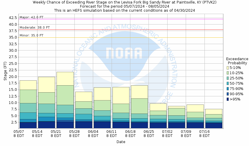
This probabilistic forecast is issued by the Ohio River Forecast Center.
tab left off Hydrograph tab right off tab left off River at a Glance tab right off tab left off Download tab right off tab left on tab right on
About this graph
Forecasts for the Levisa Fork at Paintsville are issued routinely year-round.
Return to Area Map

Upstream Gauge - at Prestonsburg Upstream Gauge Downstream Gauge Downstream Gauge - at Fullers Station
Zoom Level:13
Flood Categories (in feet)
Major Flood Stage: 42
Moderate Flood Stage: 38
Flood Stage: 35
Action Stage: 28
Low Stage (in feet): -9999

Historic Crests
(1) 46.60 ft on 02/01/1862
(2) 45.92 ft on 01/31/1957
(3) 44.20 ft on 03/14/1963
(4) 42.19 ft on 04/06/1977
(5) 42.15 ft on 02/04/1939
(6) 42.00 ft on 03/24/1929
(7) 42.00 ft on 01/29/1918
(8) 41.36 ft on 03/01/1955
(9) 41.06 ft on 01/09/1946
(10) 41.06 ft on 05/08/1958
Show More Historic Crests

(P): Preliminary values subject to further review.

Recent Crests
(1) 39.72 ft on 03/01/2021 (P)
(2) 35.00 ft on 02/24/2019 (P)
(3) 37.67 ft on 02/17/2003
(4) 40.45 ft on 05/09/1984
(5) 34.21 ft on 12/09/1978
(6) 42.19 ft on 04/06/1977
(7) 35.17 ft on 01/12/1974
(8) 37.26 ft on 02/26/1972
(9) 37.85 ft on 03/08/1967
(10) 44.20 ft on 03/14/1963
Show More Recent Crests

(P): Preliminary values subject to further review.

Low Water Records
(1) 1.06 ft on 07/23/1930
(2) 1.36 ft on 09/20/1955
(3) 1.50 ft on 10/20/1962
Show More Low Water Records
KML Image
Gauge LocationGauge Map Marker
Disclaimer
Latitude/Longitude Disclaimer: The gauge location shown in the above map is the approximate location based on the latitude/longitude coordinates provided to the NWS by the gauge owner.
Flood Impacts & Photos Collapse
If you notice any errors in the below information, please contact our Webmaster
47.4 100 year return period flood.
45.92 Flooding will exceed the highest flood on record. Ninety percent of businesses and eighty percent of homes are flooded.
44.6 50 year return period flood.
44 Right bank overtopped.
42 Major flooding occurs. Businesses begin to flood.
39 10 year return period flood.
38 Moderate flooding occurs. Water enters houses along Bridge Steet, Frank Street, and Euclid Avenue.
35.5 Water is in the Veterans Referral Center building on Euclid Avenue.
35 Low lying areas flood. The underpass at KY 40 is closed, separating the town east of the river. Left bank is overtopped, flooding Bridge Street.
32 Water covers low spot on underpass of KY 40.
Photos
(1) Staff Gage
(2) Lower Crest Gage
(3) Gage House
(4) Looking Downstream from Bridge
(5) Staff Gage on Bridge Pier
(6) Small Staff Gage Section
(7) Staff Gage on Bridge Pier
(8) Upper Crest Gage
(9) Looking Upstream from Bridge
(10) Wireweight Gage

Other Real-time and/or Archive Data Sources:

Additional Information Collapse
Short Range (1-10 Day) Ensemble River Forecasts
Medium Range (3-7 Day) Ensemble River Forecasts
How low could the river get?
Collaborative Agencies Collapse
The National Weather Service prepares its forecasts and other services in collaboration with agencies like the US Geological Survey, US Bureau of Reclamation, US Army Corps of Engineers, Natural Resource Conservation Service, National Park Service, ALERT Users Group, Bureau of Indian Affairs, and many state and local emergency managers across the country. For details, please click here.
NWS Information
National Weather Service
Jackson Weather Forecast Office
1329 Airport Road
Jackson, KY 41339
(606) 666-8000
Ask Questions/Webmaster
Page last modified: 2-Nov-2020 7:30 PM
Disclaimer
Credits
Glossary
Privacy Policy
About Us
Career Opportunities