Skip Navigation Link weather.gov  
NOAA logo - Click to go to the NOAA homepage National Weather Service NWS logo - Click to go to the NWS homepage
Advanced Hydrologic Prediction Service
Image background of Navigation bar Left
Navigation Bar End Cap


tab left off Hydrograph tab right off tab left off River at a Glance tab right off tab left off Download tab right off tab left on tab right on
About this graph
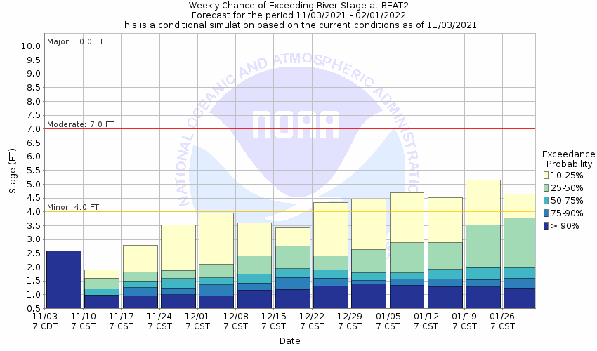
Forecasts for the Neches River at Beaumont are issued as needed during times of high water, but are not routinely available.
Return to Area Map

Upstream Gauge - at Saltwater Barrier Upstream Gauge
Zoom Level:16
Flood Categories (in feet)
Major Flood Stage: 10
Moderate Flood Stage: 7
Flood Stage: 4
Action Stage: 4
Low Stage (in feet): 0

Historic Crests
(1) 19.59 ft on 09/01/2017
(2) 13.00 ft on 10/22/1994
(3) 12.00 ft on 10/22/2006
(4) 11.60 ft on 07/03/1989
(5) 11.20 ft on 09/13/2008
Show More Historic Crests

(P): Preliminary values subject to further review.

Recent Crests
(1) 19.59 ft on 09/01/2017
(2) 8.50 ft on 06/04/2016
(3) 7.50 ft on 03/13/2016
(4) 4.00 ft on 01/20/2016
(5) 6.20 ft on 11/05/2015
Show More Recent Crests

(P): Preliminary values subject to further review.

Low Water Records
Currently none available.
KML Image
Gauge LocationGauge Map Marker
Disclaimer
Latitude/Longitude Disclaimer: The gauge location shown in the above map is the approximate location based on the latitude/longitude coordinates provided to the NWS by the gauge owner.
Flood Impacts & Photos Collapse
If you notice any errors in the below information, please contact our Webmaster
13 River is near flood of record which occurred october 1994. Widespread major flooding is occurring. Numerous homes in Northeast Beaumont and Rose City are flooded.
11.5 Major flooding is occurring. River levels are near those reached during Tropical Storm Allison in 1989. Several streets in Northeast Beaumont are flooded and impassable and water is in homes near the river. Neighborhoods on the north side of Interstate 10 in Rose City are flooded with water in approximately 4 homes.
11 Major flooding occurs at Colliers Ferry Park and around the Beaumont Country Club. Residential roads off of Pine Street are impassable and water up to homes. Several streets in Northeast Beaumont also become flooded.
10 Major flooding around the Beaumont Country Club, Colliers Ferry Park and Pine Street can be expected.
7.5 Moderate flooding is occurring. River levels are near those reached during Tropical Storm Allison in June 2001. Flooding of Colliers Ferry Park and secondary roads near the river can be expected.
7 Moderate flooding is occurring. Colliers Ferry Park is under water, and flooding of secondary roads near the river can be expected.
4 Minor flooding of Beaumont Country Club and Colliers Ferry Park can be expected. Also flooding in Northwest Orange County south of River Oaks to Bunns Bluff can be expected. Water may go over Four Oaks Ranch Road in Northwest Orange County.
Additional Information Collapse

River forecast services will be discontinued at this location on November 17th 2021. For more information: https://mesonet.agron.iastate.edu/wx/afos/p.php?pil=PNSLCH&e=202110090547

Collaborative Agencies Collapse
The National Weather Service prepares its forecasts and other services in collaboration with agencies like the US Geological Survey, US Bureau of Reclamation, US Army Corps of Engineers, Natural Resource Conservation Service, National Park Service, ALERT Users Group, Bureau of Indian Affairs, and many state and local emergency managers across the country. For details, please click here.
NWS Information
National Weather Service
Lake Charles Weather Forecast Office
500 Airport Boulevard
Lake Charles, LA 70607
(337) 477-5285
Ask Questions/Webmaster
Page last modified: 2-Nov-2020 7:29 PM
Disclaimer
Credits
Glossary
Privacy Policy
About Us
Career Opportunities