Skip Navigation Link weather.gov  
NOAA logo - Click to go to the NOAA homepage National Weather Service NWS logo - Click to go to the NWS homepage
Advanced Hydrologic Prediction Service
Image background of Navigation bar Left
Navigation Bar End Cap


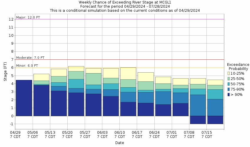
This probabilistic forecast is issued by the Lower Mississippi River Forecast Center.
tab left off Hydrograph tab right off tab left off River at a Glance tab right off tab left off Download tab right off tab left on tab right on
About this graph
Forecasts for the Atchafalaya River at Morgan City are issued routinely year-round.
Return to Area Map

Zoom Level:16
Flood Categories (in feet)
Major Flood Stage: 12
Moderate Flood Stage: 7
Flood Stage: 6
Action Stage: 4
Low Stage (in feet): 0

Historic Crests
(1) 10.53 ft on 05/28/1973
(2) 10.35 ft on 05/29/2011
(3) 10.06 ft on 07/13/2019
(4) 8.46 ft on 06/27/1957
(5) 8.29 ft on 03/15/2019
Show More Historic Crests

(P): Preliminary values subject to further review.

Recent Crests
(1) 7.93 ft on 04/13/2020 (P)
(2) 10.06 ft on 07/13/2019
(3) 8.29 ft on 03/15/2019
(4) 7.12 ft on 03/30/2018
(5) 7.18 ft on 06/03/2017
Show More Recent Crests

(P): Preliminary values subject to further review.

Low Water Records
(1) -5.40 ft on 08/25/1926
(2) -2.70 ft on 12/21/1924
(3) -2.32 ft on 10/18/1948
Show More Low Water Records
KML Image
Gauge LocationGauge Map Marker
Disclaimer
Latitude/Longitude Disclaimer: The gauge location shown in the above map is the approximate location based on the latitude/longitude coordinates provided to the NWS by the gauge owner.
Flood Impacts & Photos Collapse
If you notice any errors in the below information, please contact our Webmaster
20 There is a catastrophic flood threat. Evacuation of the cities of Berwick and Morgan City is strongly recommended. Flood walls protect the cities to an elevation of 21 feet.
12 There is a major flood threat. Back water flooding of Bayou Bouef will cause damage east of Morgan City to the community of Amelia. Structures on the river side of protection walls in Morgan City and Berwick will be under water. River traffic restrictions will be strictly enforced.
9 Structures on the river side of protection walls in Morgan City and Berwick will be under water. River traffic restrictions will be strictly enforced.
7 Buildings at the foot of Ann Street on the river side of the flood wall will flood as water overtops the Rio Oil Company dock. Buildings on the river side of the Berwick floodwall will flood. River traffic restrictions will be strictly enforced. In addition, backwater flooding could potentially impact portions areas around Lake Palourde and Stephensville.
6 Flood stage. The city dock will be under water. Water will cover the lower end of Belleview Front Street in Berwick. Vessel traffic will be affected by stronger river current and vessel traffic safety rules will be strictly enforced by the U.S. Coast Guard.
5 Floodwall gates will be closed to protect against higher stages. Vessel traffic will be affected by stronger river current and vessel traffic safety rules will be strictly enforced by the U.S. Coast Guard.
4 Action stage. Water will move up the bank and across access roads below the city dock. Floodwall gates should be closed by the 5 foot stage to protect against higher stages. Vessel traffic will be affected by stronger river current and vessel traffic safety rules will be strictly enforced by the U.S. Coast Guard.

Other Real-time and/or Archive Data Sources:

Collaborative Agencies Collapse
The National Weather Service prepares its forecasts and other services in collaboration with agencies like the US Geological Survey, US Bureau of Reclamation, US Army Corps of Engineers, Natural Resource Conservation Service, National Park Service, ALERT Users Group, Bureau of Indian Affairs, and many state and local emergency managers across the country. For details, please click here.
NWS Information
National Weather Service
Lake Charles Weather Forecast Office
500 Airport Boulevard
Lake Charles, LA 70607
(337) 477-5285
Ask Questions/Webmaster
Page last modified: 2-Nov-2020 7:29 PM
Disclaimer
Credits
Glossary
Privacy Policy
About Us
Career Opportunities