Skip Navigation Link weather.gov  
NOAA logo - Click to go to the NOAA homepage National Weather Service NWS logo - Click to go to the NWS homepage
Advanced Hydrologic Prediction Service
Image background of Navigation bar Left
Navigation Bar End Cap


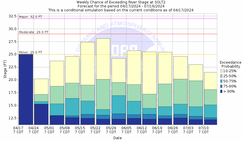
This probabilistic forecast is issued by the West Gulf River Forecast Center.
tab left off Hydrograph tab right off tab left off River at a Glance tab right off tab left off Download tab right off tab left on tab right on
About this graph
Forecasts for the Pine Island Bayou near Sour Lake are issued routinely year-round.
Return to Area Map

Zoom Level:16
Flood Categories (in feet)
Major Flood Stage: 32
Moderate Flood Stage: 29
Flood Stage: 25
Action Stage: 22
Low Stage (in feet): -9999

Historic Crests
(1) 39.68 ft on 08/30/2017
(2) 37.50 ft on 10/20/1994
(3) 35.70 ft on 09/21/2019
(4) 34.29 ft on 04/22/1979
(5) 33.70 ft on 05/22/1989
Show More Historic Crests

(P): Preliminary values subject to further review.

Recent Crests
(1) 25.73 ft on 10/02/2021
(2) 28.72 ft on 05/21/2021
(3) 25.44 ft on 11/09/2020
(4) 35.70 ft on 09/21/2019
(5) 26.04 ft on 02/15/2018
Show More Recent Crests

(P): Preliminary values subject to further review.

Low Water Records
(1) 11.20 ft on 10/28/1982
(2) 11.30 ft on 09/20/1984
(3) 11.45 ft on 11/13/1988
Show More Low Water Records
KML Image
Gauge LocationGauge Map Marker
Disclaimer
Latitude/Longitude Disclaimer: The gauge location shown in the above map is the approximate location based on the latitude/longitude coordinates provided to the NWS by the gauge owner.
Flood Impacts & Photos Collapse
If you notice any errors in the below information, please contact our Webmaster
39.68 Flood of record in August 2017 from rainfall due to Hurricane Harvey. Widespread flooding along the bayou. Water inundates hwy 105 several feet and numerous homes in Bevil Oaks are flooded, some up to nine feet.
38.5 Water reaches the instrument shelf.
37.49 The river is at its previous flood of record reached on October 20th 1994. Widespread major flooding occurs. Numerous homes in Bevil Oaks have 3 to 4 feet of water in them.
35.5 Water reaches the gage shelter floor.
34 Water reaches homes along Old Sour Lake Road near the river.
32 Major lowland flooding occurs. Several homes on Riverbend Drive in Bevil Oaks have water in them. Water reaches floor of bridge along Old Sour Lake Road.
31 Homes in the Bevil oaks and Pinewood areas begin to flood.
30.5 Riverbend Drive in Bevil Oaks is impassable.
29 Moderate lowland flooding will occur. Water covers roads in Bevil Oaks.
25 Water inundates roads in lowland areas near the river. Low spots on Old Sour Lake Road are under water.
22 River is at bankfull stage.

Other Real-time and/or Archive Data Sources:

Collaborative Agencies Collapse
The National Weather Service prepares its forecasts and other services in collaboration with agencies like the US Geological Survey, US Bureau of Reclamation, US Army Corps of Engineers, Natural Resource Conservation Service, National Park Service, ALERT Users Group, Bureau of Indian Affairs, and many state and local emergency managers across the country. For details, please click here.
NWS Information
National Weather Service
Lake Charles Weather Forecast Office
500 Airport Boulevard
Lake Charles, LA 70607
(337) 477-5285
Ask Questions/Webmaster
Page last modified: 2-Nov-2020 7:29 PM
Disclaimer
Credits
Glossary
Privacy Policy
About Us
Career Opportunities