Skip Navigation Link weather.gov  
NOAA logo - Click to go to the NOAA homepage National Weather Service NWS logo - Click to go to the NWS homepage
Advanced Hydrologic Prediction Service
Image background of Navigation bar Left
Navigation Bar End Cap


This probabilistic forecast is issued by the Lower Mississippi River Forecast Center.
tab left off Hydrograph tab right off tab left off River at a Glance tab right off tab left off Download tab right off tab left on tab right on
Experimental Short Range Forecast Uncertainty (AHPS) - External Links: Product Description Document | Customer Survey
About this graph
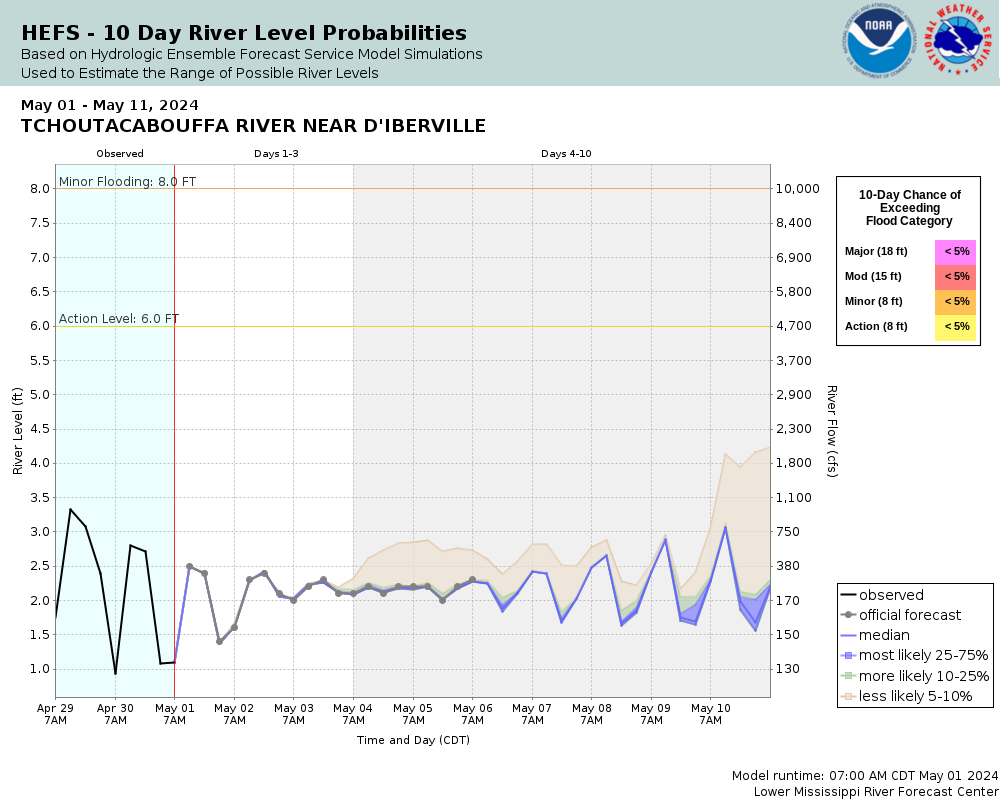
Forecasts for the Tchoutacabouffa River near D Iberville are issued routinely year-round.
Return to Area Map

Zoom Level:16
Flood Categories (in feet)
Major Flood Stage: 18
Moderate Flood Stage: 15
Flood Stage: 8
Action Stage: 8
Low Stage (in feet): -9999

Historic Crests
(1) 19.00 ft on 09/30/1998
(2) 18.10 ft on 05/10/1995
(3) 16.80 ft on 08/16/1987
(4) 16.20 ft on 04/02/2005
(5) 15.96 ft on 08/30/2021
Show More Historic Crests

(P): Preliminary values subject to further review.

Recent Crests
(1) 13.40 ft on 08/26/2022
(2) 11.81 ft on 09/16/2021
(3) 15.96 ft on 08/30/2021
(4) 10.64 ft on 06/23/2021
(5) 9.24 ft on 06/22/2021
Show More Recent Crests

(P): Preliminary values subject to further review.

Low Water Records
(1) -2.12 ft on 01/20/2019
(2) -1.90 ft on 01/17/2018
(3) -1.66 ft on 02/09/2016
(4) -1.40 ft on 02/09/2017
(5) -1.31 ft on 03/05/2015
Show More Low Water Records
KML Image
Gauge LocationGauge Map Marker
Disclaimer
Latitude/Longitude Disclaimer: The gauge location shown in the above map is the approximate location based on the latitude/longitude coordinates provided to the NWS by the gauge owner.
Flood Impacts & Photos Collapse
If you notice any errors in the below information, please contact our Webmaster
20 Extensive flooding will occur along the river from the Jackson County line south to Interstate 10 around Campbell Drive and Cortney Lane. Portions of MS Old Highway 15 and Old Highway 67 will be flooded, along with Lickskillet Rd. Evacuations may be necessary.
19 Flood of Record occurred on September 30, 1998. There will be widespread flooding from Mississippi Highway 15 east to the Jackson County line and south to Interstate 10.
18 Major flooding will occur in several homes along the river from about two miles north of the bridge to Interstate 10.
17 Flooding will close most roads, including the Cyprus Creek Road bridge across the river at the Harrison-Jackson county line. Homes below Cyprus Creek west of Mississippi Highway 67 will remain flooded and the Lamey Bridge Road east of the River will remain closed.
12 Lamey Bridge will be closed and Lamey Bridge Road will be impassable from Mason Blvd to Johnson Still Road.
10 Recreational camps will be inaccessible. Property along Lamey Bridge Road will be inundated. The water level will be at the under carriage of the bridge. Strong currents will flow across the bridge approaches.
8 Roads along the river will be impassable. A few homes will be isolated.
7 The banks will overflow a short distance upstream and downstream of Lamey Bridge.

Other Real-time and/or Archive Data Sources:

Collaborative Agencies Collapse
The National Weather Service prepares its forecasts and other services in collaboration with agencies like the US Geological Survey, US Bureau of Reclamation, US Army Corps of Engineers, Natural Resource Conservation Service, National Park Service, ALERT Users Group, Bureau of Indian Affairs, and many state and local emergency managers across the country. For details, please click here.
NWS Information
National Weather Service
New Orleans/Baton Rouge Weather Forecast Office
62300 Airport Rd.
Slidell, LA 70460-5243
(504) 522-7330
Ask Questions/Webmaster
Page last modified: 2-Nov-2020 7:29 PM
Disclaimer
Credits
Glossary
Privacy Policy
About Us
Career Opportunities