Latitude/Longitude Disclaimer: The gauge location shown in the above map
is the approximate location based on the latitude/longitude coordinates
provided to the NWS by the gauge owner.
Flood Impacts & Photos
If you notice any errors in the below information, please contact our Webmaster
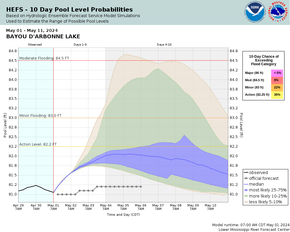
90
Expect near record flooding with nearly all homes suffering from flooding in and around the lake. Travel by boat will be the only effective means of travel as all secondary roadways will be flooded and impassable.
86
Expect severe flooding of a few unstilted cabins on the lake with nearly all roads around the lake suffering flooding in low areas.
84
Expect significant flooding of several secondary roadways that will result in several residents being cutoff from major highways. Several low are homes will be in danger of flooding and homeowners should take steps to protect property. Nearly all camps will suffer from flooding.
83
Expect flooding of secondary roadways with some camps suffering overflow. Boats should be moved from boathouses to prevent damage to boats and boathouses, otherwise boats may actually rise through the roofs of boathouses with the high water.
During periods of possible very heavy rainfall, river forecasts may take into account precipitation amounts expected 30, 36, or even 48 hours into the future from the forecast issuance time.
Gage zero datum is 40.20 feet. Changed October 1, 2013.
Collaborative Agencies
The National Weather Service prepares its forecasts and other services in collaboration with agencies like the US Geological Survey, US Bureau of Reclamation, US Army Corps of Engineers, Natural Resource Conservation Service, National Park Service, ALERT Users Group, Bureau of Indian Affairs, and many state and local emergency managers across the country. For details, please click here.
NWS Information
National Weather Service
New Orleans/Baton Rouge Weather Forecast Office
62300 Airport Rd.
Slidell, LA 70460-5243
(504) 522-7330 Ask Questions/Webmaster
Page last modified: 2-Nov-2020 7:29 PM