Skip Navigation Link weather.gov  
NOAA logo - Click to go to the NOAA homepage National Weather Service NWS logo - Click to go to the NWS homepage
Advanced Hydrologic Prediction Service
Image background of Navigation bar Left
Navigation Bar End Cap


This probabilistic forecast is issued by the Ohio River Forecast Center.
tab left off Hydrograph tab right off tab left off River at a Glance tab right off tab left off Download tab right off tab left off Inundation
Mapping
tab right off tab left on tab right on
About this graph
Forecasts for the Kentucky River at Frankfort Lock are issued routinely year-round.
Return to Area Map

Zoom Level:13
Flood Categories (in feet)
Major Flood Stage: 40
Moderate Flood Stage: 35
Flood Stage: 31
Action Stage: 29
Low Stage (in feet): -9999

Historic Crests
(1) 48.47 ft on 12/10/1978
(2) 47.46 ft on 01/25/1937
(3) 45.22 ft on 03/03/1997
(4) 44.17 ft on 02/16/1989
(5) 42.84 ft on 05/05/2010
(6) 42.80 ft on 02/01/1883
(7) 42.25 ft on 04/16/1972
(8) 40.73 ft on 03/01/1962
(9) 40.16 ft on 03/05/2021
(10) 38.99 ft on 05/09/1984
Show More Historic Crests

(P): Preliminary values subject to further review.

Recent Crests
(1) 40.16 ft on 03/05/2021
(2) 32.33 ft on 02/25/2019
(3) 36.15 ft on 04/05/2015
(4) 42.84 ft on 05/05/2010
(5) 34.41 ft on 06/01/2004
(6) 35.16 ft on 02/20/2003
(7) 35.81 ft on 03/22/2002
(8) 45.22 ft on 03/03/1997
(9) 33.75 ft on 05/20/1995
(10) 34.63 ft on 03/11/1994
Show More Recent Crests

(P): Preliminary values subject to further review.

Low Water Records
(1) -2.60 ft on 09/04/1885
(2) 3.20 ft on 11/01/1908
(3) 3.50 ft on 10/10/1904
Show More Low Water Records
KML Image
Gauge LocationGauge Map Marker
Disclaimer
Latitude/Longitude Disclaimer: The gauge location shown in the above map is the approximate location based on the latitude/longitude coordinates provided to the NWS by the gauge owner.
Flood Impacts & Photos Collapse
If you notice any errors in the below information, please contact our Webmaster
51.5 Water reaches the top of protection in South Frankfort.
51 Water reaches the top of protection in North Frankfort.
48 Areas outside of floodwall are covered. Many county roads are closed.
43 Bellepoint is cut off. Indian Gap Road, Bates Road, and River Valley Road flood. Water Plant is affected. Water crosses Wilkenson Blvd. at Reilly Rd.
40 Paul Sawyer Drive, East Second Street, East Fourth Street and Admirals Landing flood. The entrance at McDonald Ferry Road floods. The campground at Steele Branch Road is closed. Warehouses along Great Buffalo Trace Rd. flood.
39 Portions of Logan Street, Norton Street and Murray Street flood. Riverboat Landing is flooded.
38 KY 420 (Old Lawrenceburg Road) closes. Wilkerson Street, Watson Court, Wilson Street, and Kentucky Avenue flood. Many basements of homes flood.
37 Taylor Avenue floods near quarry. Swallowfield Road floods at Bates Road.
36 Travis Circle, Onans Bend Road, and Polsgrove Road flood.
33 Steele Branch Road floods at dead end. Stoney Creek Road closes.
31 Benson Valley Road floods. Water approaches Stoney Creek Road.
27 Lewis Ferry Road floods.
24 North Stoney Creek Road floods.
Photos
(1) Gage House
(2) Wire Weight Gage
(3) Upstream from the Gage Showing Quarry
(4) Downstream from the Gage
(5) Wilson Street at Bellepoint Park
(6) Upstream from Lock
(7) Upper Staff Sections
(8) Upper Pool Staff Gage
(9) Upper Pool Lock Gate
(10) Upper Pool
(11) Lower Lock Staff Gage
(12) Lock Chamber and Lower Lock Gate
(13) Highest Staff Section
(14) Downstream From Lock
(15) Dam from the Left Bank
(16) Dam from the Right Bank
(17) Old Lockmaster House
(18) Flood Levee in South Frankfort

Other Real-time and/or Archive Data Sources:

Additional Information Collapse
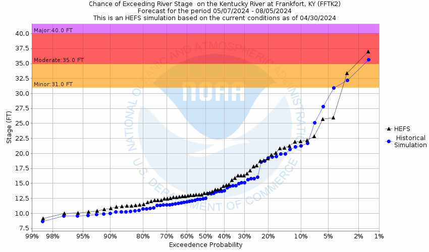
Potential River Levels - Used to
Potential River Levels
Used to Estimate the Chance of Flooding and the Range of Possible River Levels
10 Day (HEFS) 10 Day (NAEFS) River Forecast VS. River Potential
HEFS Ensemble NAEFS Ensemble River Forecast vs Potential

Note: Use the official hydrograph at the top of this web page for river levels within the next 72 hours.

Click individual graphics to enlarge.

USGS Average Streamflow
USGS Flood Inundation Mapper
How low could the river get?
Collaborative Agencies Collapse
The National Weather Service prepares its forecasts and other services in collaboration with agencies like the US Geological Survey, US Bureau of Reclamation, US Army Corps of Engineers, Natural Resource Conservation Service, National Park Service, ALERT Users Group, Bureau of Indian Affairs, and many state and local emergency managers across the country. For details, please click here.
NWS Information
National Weather Service
Louisville Weather Forecast Office
6201 Theiler Lane
Louisville, KY 40229
(502) 969-8842
Ask Questions/Webmaster
Page last modified: 2-Nov-2020 7:30 PM
Disclaimer
Credits
Glossary
Privacy Policy
About Us
Career Opportunities