Skip Navigation Link weather.gov  
NOAA logo - Click to go to the NOAA homepage National Weather Service NWS logo - Click to go to the NWS homepage
Advanced Hydrologic Prediction Service
Image background of Navigation bar Left
Navigation Bar End Cap


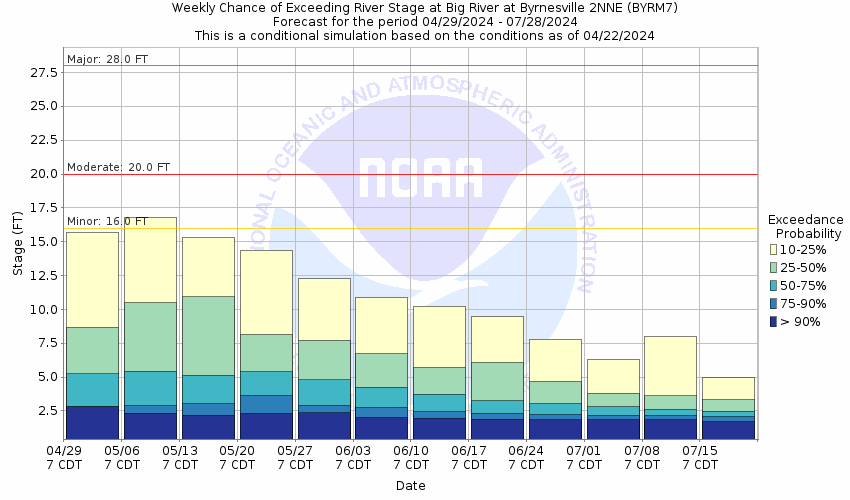
This probabilistic forecast is issued by the North Central River Forecast Center.
tab left off Hydrograph tab right off tab left off River at a Glance tab right off tab left off Download tab right off tab left on tab right on
About this graph
Forecasts for the Big River at Byrnesville are issued as needed during times of high water, but are not routinely available.
Return to Area Map

Zoom Level:14
Flood Categories (in feet)
Major Flood Stage: 28
Moderate Flood Stage: 20
Flood Stage: 16
Action Stage: 13
Low Stage (in feet): -9999

Historic Crests
(1) 30.20 ft on 08/21/1915
(2) 30.09 ft on 05/01/2017
(3) 29.37 ft on 09/25/1993
(4) 27.61 ft on 11/16/1993
(5) 27.57 ft on 04/12/1994
(6) 27.57 ft on 03/20/2008
(7) 27.18 ft on 12/29/2015
(8) 26.47 ft on 11/21/1985
(9) 26.42 ft on 05/02/1983
(10) 26.41 ft on 07/01/1957
Show More Historic Crests

(P): Preliminary values subject to further review.

Recent Crests
(1) 19.70 ft on 08/05/2023 (P)
(2) 21.78 ft on 03/26/2023 (P)
(3) 19.70 ft on 03/05/2023 (P)
(4) 20.39 ft on 02/19/2022
(5) 16.47 ft on 04/30/2021 (P)
(6) 18.46 ft on 03/20/2021
(7) 18.67 ft on 03/14/2021
(8) 16.04 ft on 01/26/2021
(9) 16.65 ft on 05/25/2020
(10) 16.70 ft on 04/25/2020
Show More Recent Crests

(P): Preliminary values subject to further review.

Low Water Records
(1) 1.05 ft on 08/16/2007
(2) 1.15 ft on 07/28/2012
(3) 1.40 ft on 09/13/2005
Show More Low Water Records
KML Image
Gauge LocationGauge Map Marker
Disclaimer
Latitude/Longitude Disclaimer: The gauge location shown in the above map is the approximate location based on the latitude/longitude coordinates provided to the NWS by the gauge owner.
Flood Impacts & Photos Collapse
If you notice any errors in the below information, please contact our Webmaster
30.3 The porch of the upstream left bank residence floods at this level.
29.6 The main floor at the Byrnesville mill begins to flood.
29.4 The floor of the gage shed begins to flood.
28 At this height, several homes along Burgan Grove Road are flooded.
22.4 At this level, Twin Rivers Bridge Road must be closed.
20.5 Burgan Grove Road begins flooding near Cottage Grove Road, cutting off access to Cottage Grove Road. Highway W near Hoene Spring is closed as water crosses the pavement.
19.3 South Byrnesville Road goes under water near this level.
19.1 Backyards and one basement along Burgan Grove Road 2 miles west of House Springs begin to flood.
19 Dutch Creek Road south of Byrnesville and Byrnesville Road near John McKeever Road north of Byrnesville begin to flood.
18.1 State Highway BB southeast of Cedar Hill will be closed near this height.
18 Cedar Hill Road at Cedar Hill and Klondike Road south of Cedar Hill begin to flood near this height.
15.5 Rockford Beach Park at the Highway MM bridge begins flooding.
Photos
(1) Missouri Route W near Rockford Beach Park on May 1, 2017.
(2) Cedar Hill Road at the Big River bridge looking south during flood of April/May 2017.
(3) Highway Y bridge at the Big River west of Hillsboro in early May 2017.
(4) Reginald Drive off Lower Byrnes Mill Road during the April/May flood of 2017.
(5) Structures along Wolf Street in Cedar Hill during the April/May flood of 2017.
(6) House along South Byrnesville Rd. just west of the bridge on April 29, 2011 with a stage of 22.4 ft.
(7) South Byrnesville Road just east of the bridge on April 29, 2011 at a stage of 22.4 feet.
(8) Burgan Grove Road at Cottage Grove Road on April 29, 2011 with a stage near 22.5 ft.
(9) Highway W just north of Hoene Spring on April 29, 2011 with a stage near 22.7 feet.
(10) Rockford Beach near the Highway W bridge on April 29, 2011 at a stage near 22.5 feet.
(11) Byrnesville looking upstream
(12) Byrnesville looking downstream

Other Real-time and/or Archive Data Sources:

Additional Information Collapse
How low could the river get?
Collaborative Agencies Collapse
The National Weather Service prepares its forecasts and other services in collaboration with agencies like the US Geological Survey, US Bureau of Reclamation, US Army Corps of Engineers, Natural Resource Conservation Service, National Park Service, ALERT Users Group, Bureau of Indian Affairs, and many state and local emergency managers across the country. For details, please click here.
NWS Information
National Weather Service
St. Louis Weather Forecast Office
12 Missouri Research Park Drive
St. Charles, MO 63304
(636) 441-8467
Ask Questions/Webmaster
Page last modified: 2-Nov-2020 7:29 PM
Disclaimer
Credits
Glossary
Privacy Policy
About Us
Career Opportunities