Skip Navigation Link weather.gov  
NOAA logo - Click to go to the NOAA homepage National Weather Service NWS logo - Click to go to the NWS homepage
Advanced Hydrologic Prediction Service
Image background of Navigation bar Left
Navigation Bar End Cap


This probabilistic forecast is issued by the Middle Atlantic River Forecast Center.
tab left off Hydrograph tab right off tab left off River at a Glance tab right off tab left off Download tab right off tab left on tab right on
About this graph
Forecasts for the South Fork South Branch Potomac River near SF Moorefield are issued routinely year-round.
Return to Area Map

Zoom Level:14
Flood Categories (in feet)
Major Flood Stage: 14
Moderate Flood Stage: 12
Flood Stage: 10
Action Stage: 8
Low Stage (in feet): -9999

Historic Crests
(1) 19.99 ft on 11/05/1985
(2) 16.10 ft on 06/18/1949
(3) 14.90 ft on 03/17/1936
(4) 13.50 ft on 03/29/1924
(5) 12.27 ft on 09/07/1996
Show More Historic Crests

(P): Preliminary values subject to further review.

Recent Crests
(1) 10.80 ft on 06/03/2018
(2) 10.94 ft on 09/19/2003 (P)
(3) 12.27 ft on 09/07/1996
(4) 10.50 ft on 01/19/1996
(5) 19.99 ft on 11/05/1985
Show More Recent Crests

(P): Preliminary values subject to further review.

Low Water Records
(1) 0.40 ft on 08/21/1987
KML Image
Gauge LocationGauge Map Marker
Disclaimer
Latitude/Longitude Disclaimer: The gauge location shown in the above map is the approximate location based on the latitude/longitude coordinates provided to the NWS by the gauge owner.
Flood Impacts & Photos Collapse
If you notice any errors in the below information, please contact our Webmaster
20 Near record flooding expected. The entire town on the left bank of the South Fork will be flooded. Water will begin to inundate Washington and Elm, Winchester and North Main, and Ashley and Spring Streets.
16 Narly half of the town will be inundated. Maple Avenue will be flooded north of Jackson to the intersection with Spring Avenue. Kuyendall Lane and Main Street will be under water and a large part of Main Street and adjacent roads will be inundated. Water will be approaching the main floor of the chicken processing plant.
14.5 Water reaches the railroad bridge just south of town.
14 Water will be approaching the northern boundary of the business district.
12 Water will begin to inundate the sewage treatment plant. Water begins to flood Town Run Road and areas from the high school northward begin to flood. On the south end of town, Rohrbaugh Street south of the railroad tracks will begin to flood.
10 Water begins to flood pastureland south of town.
8 The river overflows mainly low lying areas.
Photos
(1) Looking Downriver at Gage on Right Bank

Other Real-time and/or Archive Data Sources:

Additional Information Collapse
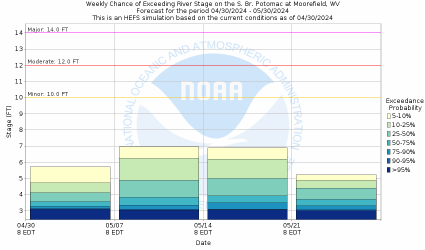
Potential River Levels - Used to
Potential River Levels
Used to Estimate the Chance of Flooding and the Range of Possible River Levels
10 Day (HEFS) 7 Day (NAEFS) 7 Day (GEFS)
HEFS Ensemble NAEFS Ensemble GEFS Ensemble

Note: Use the official hydrograph at the top of this web page for river levels within the next 72 hours.

Click individual graphics to enlarge.

Collaborative Agencies Collapse
The National Weather Service prepares its forecasts and other services in collaboration with agencies like the US Geological Survey, US Bureau of Reclamation, US Army Corps of Engineers, Natural Resource Conservation Service, National Park Service, ALERT Users Group, Bureau of Indian Affairs, and many state and local emergency managers across the country. For details, please click here.
NWS Information
National Weather Service
(Baltimore/Washington) Sterling Weather Forecast Office
43858 Weather Service Rd.
Sterling, VA 20166
(571) 888-3500
Ask Questions/Webmaster
Page last modified: 2-Nov-2020 7:30 PM
Disclaimer
Credits
Glossary
Privacy Policy
About Us
Career Opportunities