Skip Navigation Link weather.gov  
NOAA logo - Click to go to the NOAA homepage National Weather Service NWS logo - Click to go to the NWS homepage
Advanced Hydrologic Prediction Service
Image background of Navigation bar Left
Navigation Bar End Cap


This probabilistic forecast is issued by the Southeast River Forecast Center.
tab left off Hydrograph tab right off tab left off River at a Glance tab right off tab left off Download tab right off tab left off Inundation
Mapping
tab right off tab left on tab right on
About this graph
Forecasts for the N.E. Cape Fear River near Chinquapin are issued as needed during times of high water, but are not routinely available.
Return to Area Map

Downstream Gauge Downstream Gauge - near Burgaw
Zoom Level:16
Flood Categories (in feet)
Major Flood Stage: 18
Moderate Flood Stage: 16
Flood Stage: 13
Action Stage: 12
Low Stage (in feet): -9999

Historic Crests
(1) 25.77 ft on 09/17/2018
(2) 23.51 ft on 09/18/1999
(3) 22.60 ft on 08/01/1908
(4) 21.80 ft on 09/01/1928
(5) 20.16 ft on 07/07/1962
Show More Historic Crests

(P): Preliminary values subject to further review.

Recent Crests
(1) 13.90 ft on 12/22/2023
(2) 15.00 ft on 09/02/2023
(3) 16.39 ft on 02/20/2021
(4) 16.39 ft on 02/20/2021
(5) 16.18 ft on 11/16/2020
Show More Recent Crests

(P): Preliminary values subject to further review.

Low Water Records
(1) 1.00 ft on 06/08/1994
(2) 1.13 ft on 10/13/1995
(3) 1.54 ft on 10/04/1996
KML Image
Gauge LocationGauge Map Marker
Disclaimer
Latitude/Longitude Disclaimer: The gauge location shown in the above map is the approximate location based on the latitude/longitude coordinates provided to the NWS by the gauge owner.
Flood Impacts & Photos Collapse
If you notice any errors in the below information, please contact our Webmaster
25 Historic and catastrophic flooding across Duplin county, comparable to the flood following Hurricane Florence. Numerous communities cut off, and travel is next to impossible. Countless homes and businesses are flooded across the county. In the River Landing community near Wallace, devastating flooding is expected with over half of the homes significantly inundated.
22 Devastating flooding across most of the county. Travel is nearly impossible with numerous roads countywide impassable or washed out. Many homes across the county are inundated. In the River Landing community near Wallace, several homes are likely inundated, with numerous residences surrounded by water or have water up to their foundations.
20 Widespread flooding across much of the county. Many roads flooded and impassable including Highways 41 and 50 and Interstate 40. Numerous homes and communities near the river are surrounded by water, with several likely inundated. In the River Landing community near Wallace, several homes close to the river are likely surrounded by water.
18 Numerous roads flooded, and some homes and businesses are likely inundated. Water floods Highways 41 and 50, and parts of Interstate 40. Areas many miles from the river are flooded due to tributaries backing up. Water threatens homes and buildings in the River Landing community near Wallace.
16 Many secondary roads are flooded. Water affects Highways 41 and 50 and travel delays are likely. Areas many miles from the river are affected as small streams backup and flood. Muddy Creek, Cypress Creek, and Island Creek flood areas around Chinquapin.
15 Secondary roads adjacent to the river flood and may be impassable. Tributaries that drain into the river flood secondary roads. Water surrounds homes and properties in the River Landing community in Wallace.
13 Low land flooding adjacent to the river and its tributaries is expected. River access docks are impacted as well.

Other Real-time and/or Archive Data Sources:

Additional Information Collapse
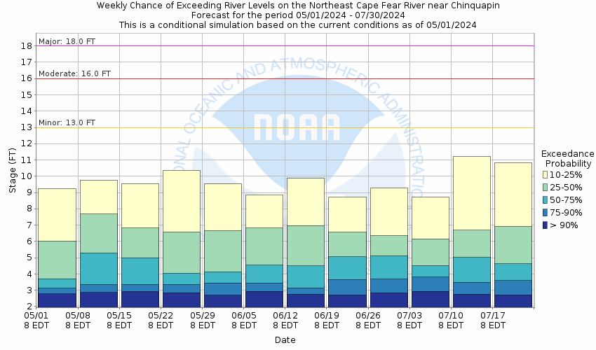
Potential River Levels - Used to
Potential River Levels
Used to Estimate the Chance of Flooding and the Range of Possible River Levels
10 Day (HEFS) 10 Day (NAEFS) 10 Day (GEFS)
HEFS Ensemble NAEFS Ensemble GEFS Ensemble

Note: Use the official hydrograph at the top of this web page for river levels within the next 72 hours.

Click individual graphics to enlarge.

Collaborative Agencies Collapse
The National Weather Service prepares its forecasts and other services in collaboration with agencies like the US Geological Survey, US Bureau of Reclamation, US Army Corps of Engineers, Natural Resource Conservation Service, National Park Service, ALERT Users Group, Bureau of Indian Affairs, and many state and local emergency managers across the country. For details, please click here.
NWS Information
National Weather Service
Newport/Morehead City Weather Forecast Office
533 Roberts Rd
Newport, NC 28570
(252) 223-5122
Ask Questions/Webmaster
Page last modified: 2-Nov-2020 7:30 PM
Disclaimer
Credits
Glossary
Privacy Policy
About Us
Career Opportunities