Skip Navigation Link weather.gov  
NOAA logo - Click to go to the NOAA homepage National Weather Service NWS logo - Click to go to the NWS homepage
Advanced Hydrologic Prediction Service
Image background of Navigation bar Left
Navigation Bar End Cap


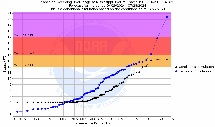
This probabilistic forecast is issued by the North Central River Forecast Center.
tab left off Hydrograph tab right off tab left off River at a Glance tab right off tab left off Download tab right off tab left on tab right on
About this graph
Forecasts for the Mississippi River at Hwy 169 at Champlin are issued as needed during times of high water, but are not routinely available.
Return to Area Map

Upstream Locations Upstream Gauge Downstream Gauge Downstream Locations
Zoom Level:16
Flood Categories (in feet)
Major Flood Stage: 17
Moderate Flood Stage: 14
Flood Stage: 12
Action Stage: 9
Low Stage (in feet): -9999

Historic Crests
(1) 17.96 ft on 04/12/1965
(2) 17.66 ft on 04/17/1965
(3) 17.56 ft on 03/06/1984
(4) 15.81 ft on 03/29/1957
(5) 15.46 ft on 04/15/1952
(6) 14.76 ft on 04/09/1997
(7) 14.29 ft on 04/20/2023 (P)
(8) 13.66 ft on 06/17/1966
Show More Historic Crests

(P): Preliminary values subject to further review.

Recent Crests
(1) 14.29 ft on 04/20/2023 (P)
(2) 11.87 ft on 05/18/2022
(3) 8.04 ft on 04/16/2021
(4) 13.11 ft on 01/13/2020
(5) 11.94 ft on 03/31/2019
(6) 9.59 ft on 04/28/2018
(7) 9.11 ft on 10/10/2017
(8) 10.76 ft on 04/10/2011
Show More Recent Crests

(P): Preliminary values subject to further review.

Low Water Records
(1) 4.14 ft on 08/17/2023
(2) 4.17 ft on 10/16/2022
(3) 4.19 ft on 10/21/2021
(4) 4.33 ft on 06/29/2020
(5) 4.50 ft on 08/23/2018
Show More Low Water Records
KML Image
Gauge LocationGauge Map Marker
Disclaimer
Latitude/Longitude Disclaimer: The gauge location shown in the above map is the approximate location based on the latitude/longitude coordinates provided to the NWS by the gauge owner.
Flood Impacts & Photos Collapse
If you notice any errors in the below information, please contact our Webmaster
17.8 Anoka - Rum River begins flooding River Avenue and Madison Street
17.3 Anoka - Rum River begins flooding 2nd Avenue and Adams Street.
17 Champlin - water backs up through sewer manholes at Applewood Pointe on Dayton Road
14.6 Anoka - water begins flooding Rice Street and Levee Avenue.
14.2 Anoka - water begins flooding the Rum River boat launch walkway.
13.5 Champlin - flooding begins on West River Parkway upstream from gage
11.26 Watercraft restrictions begin.
11 Champlin - flooding begins upstream of gage at Galloway Park
10.8 Champlin - some flooding downstream of gage on Mississippi Drive
9.4 Champlin - some flooding 3-4 miles downstream of gage below West River Road
9 Champlin - low parking lot off 411 Dayton Road begins to flood.
8.8 Champlin - low areas of Mississippi Point Park begin to flood.

Other Real-time and/or Archive Data Sources:

Additional Information Collapse
  • How low could the river go?
  • Collaborative Agencies Collapse
    The National Weather Service prepares its forecasts and other services in collaboration with agencies like the US Geological Survey, US Bureau of Reclamation, US Army Corps of Engineers, Natural Resource Conservation Service, National Park Service, ALERT Users Group, Bureau of Indian Affairs, and many state and local emergency managers across the country. For details, please click here.
    NWS Information
    National Weather Service
    Twin Cities/Chanhassen Weather Forecast Office
    1733 Lake Drive West
    Chanhassen, MN 55317-8581
    (952) 361-6708
    Ask Questions/Webmaster
    Page last modified: 2-Nov-2020 7:29 PM
    Disclaimer
    Credits
    Glossary
    Privacy Policy
    About Us
    Career Opportunities