Skip Navigation Link weather.gov  
NOAA logo - Click to go to the NOAA homepage National Weather Service NWS logo - Click to go to the NWS homepage
Advanced Hydrologic Prediction Service
Image background of Navigation bar Left
Navigation Bar End Cap


This probabilistic forecast is issued by the Lower Mississippi River Forecast Center.
tab left off Hydrograph tab right off tab left off River at a Glance tab right off tab left off Download tab right off tab left on tab right on
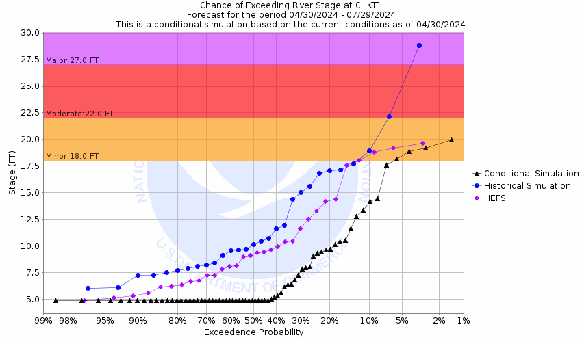
About this graph
Forecasts for the S. Chickamauga Creek near Chickamauga are issued routinely year-round.
Return to Area Map

Zoom Level:15
Flood Categories (in feet)
Major Flood Stage: 27
Moderate Flood Stage: 22
Flood Stage: 18
Action Stage: 16
Low Stage (in feet): -9999

Historic Crests
(1) 29.29 ft on 05/08/2003
(2) 28.72 ft on 02/17/1990
(3) 28.70 ft on 03/17/1973
(4) 28.54 ft on 09/22/2009
(5) 27.73 ft on 03/30/1951
(6) 27.54 ft on 03/29/1994
(7) 26.83 ft on 11/29/1948
(8) 26.43 ft on 12/27/2015
(9) 25.93 ft on 04/14/2020
(10) 25.70 ft on 12/19/1961
Show More Historic Crests

(P): Preliminary values subject to further review.

Recent Crests
(1) 17.93 ft on 01/10/2024 (P)
(2) 18.85 ft on 02/24/2022
(3) 20.20 ft on 04/01/2021
(4) 18.40 ft on 03/27/2021
(5) 21.96 ft on 03/19/2021
(6) 25.93 ft on 04/14/2020
(7) 19.03 ft on 03/10/2019
(8) 21.99 ft on 02/24/2019
(9) 17.99 ft on 02/21/2019
(10) 17.81 ft on 04/24/2018
Show More Recent Crests

(P): Preliminary values subject to further review.

Low Water Records
(1) 0.24 ft on 10/05/1970
(2) 3.92 ft on 10/10/2016
(3) 4.02 ft on 10/06/2019
(4) 4.06 ft on 10/27/2023
(5) 4.27 ft on 09/29/2012
KML Image
Gauge LocationGauge Map Marker
Disclaimer
Latitude/Longitude Disclaimer: The gauge location shown in the above map is the approximate location based on the latitude/longitude coordinates provided to the NWS by the gauge owner.
Flood Impacts & Photos Collapse
If you notice any errors in the below information, please contact our Webmaster
30 The airport is closed. Interstates 24 and 75 in East Ridge are impassable.
29 The airport can still function at a reduced level. Access to the airport becomes difficult.
28 Major flooding occurs in areas around the airport in Chattanooga. Several roads are blocked, including Highway 153 near Shepherd Road. Many homes in East Ridge are flooded, and some businesses affected.
27 Homes on Arlena Circle (off Shallowford Road) are evacuated. Evacuations also take place at the Fountainbleau Apartments on Spring Creek Road in East Ridge.
24 A few homes in the East Ridge area are flooded.
23 Evacuations begin in some of the low lying areas around Spring Creek in the East Ridge area.
22 Airport Road is closed to traffic. A couple of homes are slightly flooded near intersection of Mack Smith Road and May Street. Flooding becomes extensive around the north end of the airport.
21 Mack Smith Road and Lovell Field Loop become impassable. Water begins to come onto Airport Road, just north of the terminal complex. West Chickamauga Creek increases to near a half mile wide in places, becoming hazardous to adjacent travel in East Ridge.
20 Mack Smith Road is closed. Water crosses Lovell Field Loop, the access road around the north end of the airport runway.
19 Water across Mack Smith road begins to impede traffic. West Chickamauga Creek overflows its banks near the Georgia state line and inundates several roads and properties in the area.
18 Water begins to cross Mack Smith Road in Catoosa County, Georgia. Flooding begins at golf courses near the confluence of South and West Chickamauga Creeks. West Chickamauga Creek begins to overflow its banks, as well.

Other Real-time and/or Archive Data Sources:

Additional Information Collapse
Find more information from the Tennessee Valley Authority (TVA): http://lakeinfo.tva.gov/htbin/streaminfo and from the Environmental Protection Agency (EPA): http://cfpub.epa.gov/surf/huc.cfm?huc_code=06020001
Collaborative Agencies Collapse
The National Weather Service prepares its forecasts and other services in collaboration with agencies like the US Geological Survey, US Bureau of Reclamation, US Army Corps of Engineers, Natural Resource Conservation Service, National Park Service, ALERT Users Group, Bureau of Indian Affairs, and many state and local emergency managers across the country. For details, please click here.
NWS Information
National Weather Service
Morristown Weather Forecast Office
5974 Commerce Blvd.
Morristown, TN 37814
(423) 586-3771
Ask Questions/Webmaster
Page last modified: 2-Nov-2020 7:30 PM
Disclaimer
Credits
Glossary
Privacy Policy
About Us
Career Opportunities