Skip Navigation Link weather.gov  
NOAA logo - Click to go to the NOAA homepage National Weather Service NWS logo - Click to go to the NWS homepage
Advanced Hydrologic Prediction Service
Image background of Navigation bar Left
Navigation Bar End Cap


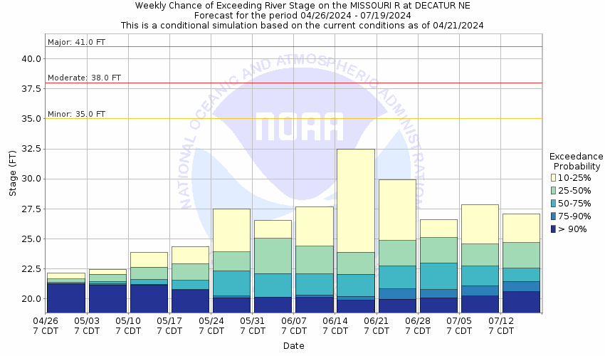
This probabilistic forecast is issued by the Missouri Basin River Forecast Center.
tab left off Hydrograph tab right off tab left off River at a Glance tab right off tab left off Download tab right off tab left on tab right on
About this graph
Forecasts for the Missouri River at Decatur are issued as needed during times of high water, but are not routinely available.
Return to Area Map

Upstream Gauge - at Sioux City Upstream Gauge Downstream Gauge Downstream Gauge - near Blair
Zoom Level:14
Flood Categories (in feet)
Major Flood Stage: 41
Moderate Flood Stage: 38
Flood Stage: 35
Action Stage: 33
Low Stage (in feet): 12.5

Historic Crests
(1) 44.41 ft on 04/16/1952
(2) 40.24 ft on 07/21/2011
(3) 36.51 ft on 03/17/2019
(4) 36.42 ft on 09/20/2019
(5) 35.72 ft on 06/03/2019
(6) 34.60 ft on 06/26/1984
(7) 32.31 ft on 07/18/1996
(8) 32.19 ft on 07/16/1993
(9) 32.18 ft on 06/27/2018
(10) 31.99 ft on 04/15/1997
Show More Historic Crests

(P): Preliminary values subject to further review.

Recent Crests
(1) 21.73 ft on 08/16/2022
(2) 21.80 ft on 09/01/2021
(3) 27.64 ft on 04/02/2020
(4) 36.42 ft on 09/20/2019
(5) 35.72 ft on 06/03/2019
(6) 36.51 ft on 03/17/2019
(7) 32.18 ft on 06/27/2018
(8) 24.69 ft on 05/30/2017
(9) 23.64 ft on 06/19/2016
(10) 22.57 ft on 07/11/2015
Show More Recent Crests

(P): Preliminary values subject to further review.

Low Water Records
(1) 13.78 ft on 01/09/1989
KML Image
Gauge LocationGauge Map Marker
Disclaimer
Latitude/Longitude Disclaimer: The gauge location shown in the above map is the approximate location based on the latitude/longitude coordinates provided to the NWS by the gauge owner.
Flood Impacts & Photos Collapse
If you notice any errors in the below information, please contact our Webmaster
44 Widespread major flooding would be prevalent along the entire reach from just upstream of Decatur downstream to the mouth of the Little Sioux River.
38 Extensive flooding along the reach would be encountered. Areas impacted will include Marina Drive as well as numerous homes along the river.
35 Local marinas, boat docks and low lying areas begin to flood.
Photos
(1) Looking downstream
(2) Looking upstream
(3) Gage house
(4) Radar Gage
Low Water Impacts Collapse
If you notice any errors in the below information, please contact our Webmaster
12.5 This is the lower operating limit for the gage.

Other Real-time and/or Archive Data Sources:

Additional Information Collapse

The graph below is from the USGS and represents river discharge.


  • USGS 7-Day Streamflow Duration Hydrograph for this location:
    Duration Hydrograph

    Duration Hydrograph Legend


  • USGS Cumulative Streamflow Hydrograph for this location:
    Duration Hydrograph of Cumulative Streamflow

How low could the river get?
Collaborative Agencies Collapse
The National Weather Service prepares its forecasts and other services in collaboration with agencies like the US Geological Survey, US Bureau of Reclamation, US Army Corps of Engineers, Natural Resource Conservation Service, National Park Service, ALERT Users Group, Bureau of Indian Affairs, and many state and local emergency managers across the country. For details, please click here.
NWS Information
National Weather Service
Omaha/Valley Weather Forecast Office
6707 N. 288th Street
Valley, NE 68064-9443
(402) 359-5166
Ask Questions/Webmaster
Page last modified: 2-Nov-2020 7:29 PM
Disclaimer
Credits
Glossary
Privacy Policy
About Us
Career Opportunities