Skip Navigation Link weather.gov  
NOAA logo - Click to go to the NOAA homepage National Weather Service NWS logo - Click to go to the NWS homepage
Advanced Hydrologic Prediction Service
Image background of Navigation bar Left
Navigation Bar End Cap


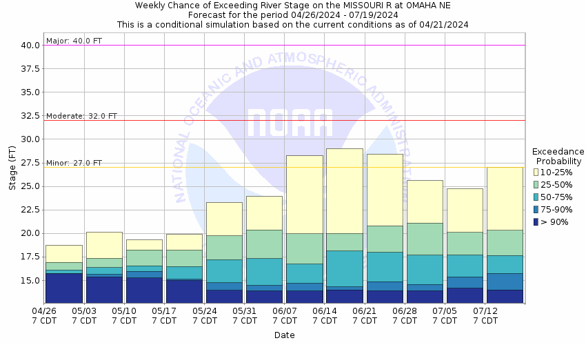
This probabilistic forecast is issued by the Missouri Basin River Forecast Center.
tab left off Hydrograph tab right off tab left off River at a Glance tab right off tab left off Download tab right off tab left on tab right on
About this graph
Forecasts for the Missouri River at Omaha are issued routinely year-round.
Return to Area Map

Upstream Gauge - near Blair Upstream Gauge
Zoom Level:15
Flood Categories (in feet)
Major Flood Stage: 40
Moderate Flood Stage: 32
Flood Stage: 27
Action Stage: 21
Low Stage (in feet): 9

Historic Crests
(1) 40.20 ft on 04/18/1952
(2) 36.29 ft on 07/02/2011
(3) 34.40 ft on 03/17/2019
(4) 34.22 ft on 04/25/1881
(5) 31.96 ft on 06/05/2019
(6) 30.58 ft on 09/22/2019
(7) 30.26 ft on 07/10/1993
(8) 29.50 ft on 06/23/1996
(9) 29.02 ft on 06/27/1984
(10) 28.92 ft on 06/29/2018
Show More Historic Crests

(P): Preliminary values subject to further review.

Recent Crests
(1) 15.54 ft on 08/18/2022
(2) 16.06 ft on 08/07/2021
(3) 21.93 ft on 04/03/2020
(4) 30.58 ft on 09/22/2019
(5) 31.96 ft on 06/05/2019
(6) 34.40 ft on 03/17/2019
(7) 28.92 ft on 06/29/2018
(8) 22.43 ft on 05/21/2017
(9) 22.91 ft on 05/01/2016
(10) 21.86 ft on 12/15/2015
Show More Recent Crests

(P): Preliminary values subject to further review.

Low Water Records
(1) 3.95 ft on 01/16/2024
(2) 4.09 ft on 12/24/2022
(3) 6.63 ft on 01/01/2014
(4) 6.64 ft on 02/03/2013
Show More Low Water Records
KML Image
Gauge LocationGauge Map Marker
Disclaimer
Latitude/Longitude Disclaimer: The gauge location shown in the above map is the approximate location based on the latitude/longitude coordinates provided to the NWS by the gauge owner.
Flood Impacts & Photos Collapse
If you notice any errors in the below information, please contact our Webmaster
40 At this level the water nears the top of the federal levee.
36 Water reaches the bottom of flood wall just north of Interstate 480. Low lying roads are also affected just east of Riverfront Drive north of the pedestrian bridge.
32.5 Floodwaters are reaching areas near Council Bluffs, specifically near Interstate 29, miler marker 56.
30.5 Floodwaters are impacting Interstate 29/680 near Crescent and northward to exit 71 near Loveland.
29 At this level water nears the base of the Council Bluffs levee. Significant lowland flooding occurs in NP Dodge Park, Freedom Park, Tom Hanafan Park, Fontenelle Forest and Haworth Park.
28 At this level most of the flood gates for the city of Council Bluffs are closed.
27 Freedom Park, Tom Hanafan Park and Fontenelle Forest begin to flood.
25 NP Dodge Park in north Omaha is flooding and will be closed. A casino parking lot begins to flood along the Iowa side of the river. In addition, Haworth Park located in Bellevue begins to flood.
21 At this level the City of Council Bluffs begins closing flood gates.
19 At this level, the City of Council Bluffs begins to close drainage gates that discharge into the river.
Photos
(1) Looking upstream near gage site
(2) Looking downstream from pedestrian bridge
Low Water Impacts Collapse
If you notice any errors in the below information, please contact our Webmaster
3 This is the lower operating limit for the gage.
9 Water intake structures along this stretch of the river begin to be monitored for possible exposure.

Other Real-time and/or Archive Data Sources:

Additional Information Collapse
The April 25, 1881 crest was read at the old Union Pacific Railroad bridge, located about 0.5 miles downstream of the current site. Elevation of reading is NGVD 1929 datum. The 1881 value at the datum then is use is available here.


The graph below is from the USGS and represents river discharge.


  • USGS 7-Day Streamflow Duration Hydrograph for this location:
    Duration Hydrograph

    Duration Hydrograph Legend


  • USGS Cumulative Streamflow Hydrograph for this location:
    Duration Hydrograph of Cumulative Streamflow

How low could the river get?
Collaborative Agencies Collapse
The National Weather Service prepares its forecasts and other services in collaboration with agencies like the US Geological Survey, US Bureau of Reclamation, US Army Corps of Engineers, Natural Resource Conservation Service, National Park Service, ALERT Users Group, Bureau of Indian Affairs, and many state and local emergency managers across the country. For details, please click here.
NWS Information
National Weather Service
Omaha/Valley Weather Forecast Office
6707 N. 288th Street
Valley, NE 68064-9443
(402) 359-5166
Ask Questions/Webmaster
Page last modified: 2-Nov-2020 7:29 PM
Disclaimer
Credits
Glossary
Privacy Policy
About Us
Career Opportunities