Historic Crests
(1) 26.10 ft on 05/01/2010
(2) 23.78 ft on 05/04/1979
(3) 19.73 ft on 03/21/1955
(4) 19.15 ft on 06/17/1960
(5) 18.38 ft on 02/27/1962 Show More Historic Crests
(P): Preliminary values subject to further review.
Recent Crests
(1) 13.44 ft on 04/22/2017
(2) 11.17 ft on 12/25/2015
(3) 11.43 ft on 03/04/2015
(4) 11.95 ft on 02/05/2014
(5) 15.30 ft on 04/28/2013 Show More Recent Crests
(P): Preliminary values subject to further review.
Latitude/Longitude Disclaimer: The gauge location shown in the above map
is the approximate location based on the latitude/longitude coordinates
provided to the NWS by the gauge owner.
Flood Impacts & Photos
If you notice any errors in the below information, please contact our Webmaster
24
Many roads and properties in and near industrial, commercial, and residential areas along the creek are flooded, including locations near Harding Place and Harding Industrial Drive, Franklin Limestone Road, portions of Antioch Pike from near Haywood Lane to near Blue Hole Road including Antioch Middle School, Cummings Park Drive, and Waikiki Blvd.
22
Flooding along Mill Creek is impacting many idustrial, commercial, and residential areas. Locations near Harding Place and Harding Industrial Drive, Franklin Limestone Road, Antioch Pike and Haywood Lane, Cummings Park Drive, and Waikiki Blvd are hardest hit. Area roads are also flooded, including Franklin Limestone Road, portions of Antioch Pike between Blue Hole Road and Reeves Road and the bridge between Haywood Lane and Richards Road, and Mc Gavock Pike north of Harding Place.
20
Many roads near mill creek are flooded, including franklin limestone road, portions of antioch pike between blue hole road and reeves road and the bridge between haywood lane and richards road, and mc gavock pike north of harding place. Flooding of industrial, commercial, and residential property is occurring, especially near harding place and harding industrial drive, franklin limestone road, antioch pike and haywood lane, cummings park drive, and waikiki blvd.
19
Flooding of industrial and commercial areas begins near Harding Place and Harding Industrial Drive, Franklin Limestone Rroad, Antioch Pike and Haywood Lane, and Cummings Park Drive. Antioch Pike between Blue Hole Road and Reeves Road, and Mc Gavock Pike north of Harding Place are flooded, as well as the athletic fields and parking areas of Antioch Middle School, Ezell Road Park, and Antioch Park.
18
Water begins to approach industrial and commercial areas near Harding Place and Harding Industrial Drive, Franklin Limestone Road, Antioch Pike and Haywood Lane, and Cummings Park Drive. Antioch Pike between Blue Hole Road and Reeves Road, and Mc Gavock Pike north of Harding Place are flooded, as well as the athletic fields and parking areas of Antioch Middle School, Ezell Road Park, and Antioch Park.
17
Significant flooding is occurring in Ezell Road Park and Antioch Park. Industrial areas near Franklin Limestone Road, Haywood Lane, Antioch Pike, Blue Hole Road, and Harding Place are also experiencing flooding that may lead to significant damage. Antioch Pike between Blue Hole Road and Reeves Road is flooded, and water approaches Mc Gavock Pike north of Harding Place.
16
Flooding of property along the creek is occurring, including Ezell Road Park and Antioch Park, and industrial areas near Franklin Limestone Road, Haywood Lane, Antioch Pike, Blue Hole Road, and Harding Place.
15
Parking areas and athletic fields at Antioch Middle School begin to flood, and water approaches low lying areas along Antioch Pike between Blue Hole Road and Reeves Road.
14
Flooding of properties along the creek begins, particularly industrial areas near Franklin Limestone Road, Haywood Lane, Antioch Pike, Blue Hole Road, and Harding Place. Also flooding of Ezell Road Park and Antioch Park is occurring.
13
Portions of Ezell Road Park and Antioch Park are inundated, and property of Antioch Middle School along the creek becomes inundated.
12
Water begins to inundate low lying areas along the creek from Interstate 24 to near Harding Place, including Ezell Road Park and Antioch Park.
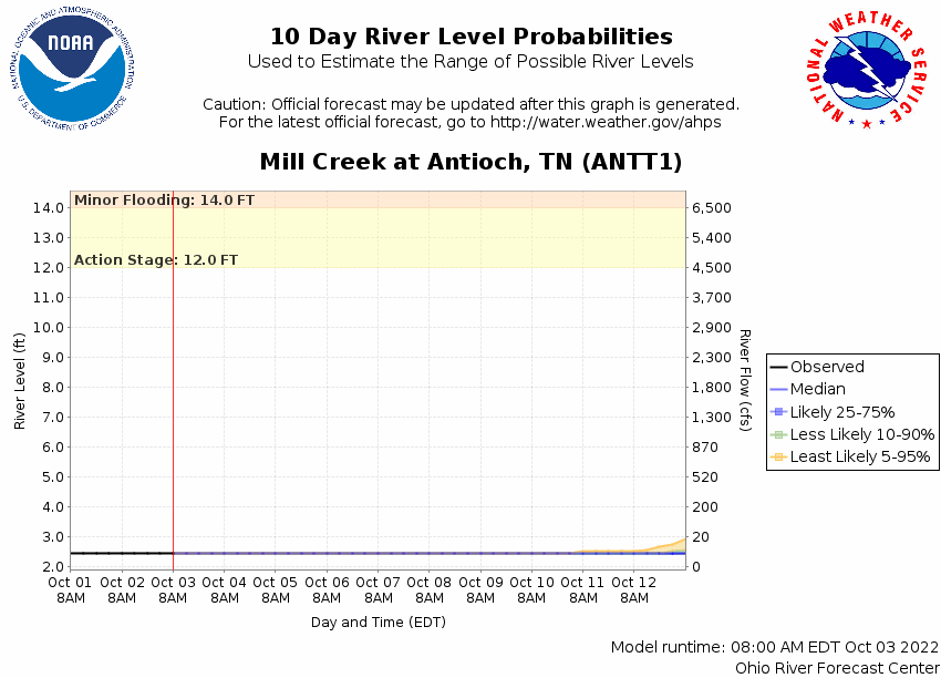
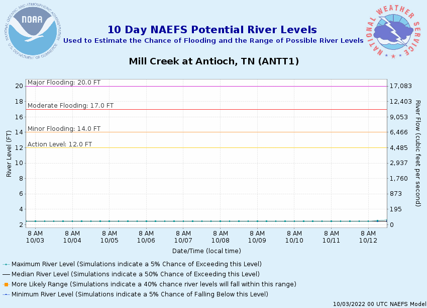
Potential River Levels Used to Estimate the Chance of Flooding and
the Range of Possible River Levels
10 Day (HEFS)
7 Day (NAEFS)
7 Day (GEFS)
Note: Use the official hydrograph at the top of this web page
for river levels within the next 72 hours.
Click individual graphics to
enlarge.
Collaborative Agencies
The National Weather Service prepares its forecasts and other services in collaboration with agencies like the US Geological Survey, US Bureau of Reclamation, US Army Corps of Engineers, Natural Resource Conservation Service, National Park Service, ALERT Users Group, Bureau of Indian Affairs, and many state and local emergency managers across the country. For details, please click here.
NWS Information
National Weather Service
Nashville Weather Forecast Office
500 Weather Station Road
Old Hickory, TN 37138
(615) 754-4633 Ask Questions/Webmaster
Page last modified: 2-Nov-2020 7:29 PM