Skip Navigation Link weather.gov  
NOAA logo - Click to go to the NOAA homepage National Weather Service NWS logo - Click to go to the NWS homepage
Advanced Hydrologic Prediction Service
Image background of Navigation bar Left
Navigation Bar End Cap


This probabilistic forecast is issued by the Lower Mississippi River Forecast Center.
tab left off Hydrograph tab right off tab left off River at a Glance tab right off tab left off Download tab right off tab left on tab right on
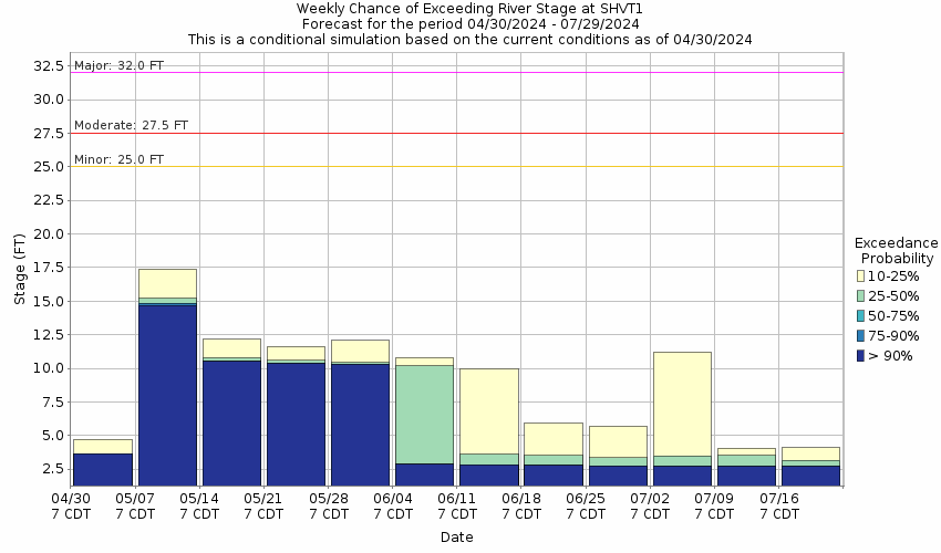
About this graph
Forecasts for the Duck River near Shelbyville are issued routinely year-round.
Return to Area Map

Downstream Gauge Downstream Gauge - at Columbia
Zoom Level:16
Flood Categories (in feet)
Major Flood Stage: 32
Moderate Flood Stage: 27.5
Flood Stage: 25
Action Stage: 21
Low Stage (in feet): 0

Historic Crests
(1) 42.00 ft on 03/29/1926
(2) 39.60 ft on 03/24/1929
(3) 38.40 ft on 02/13/1948
(4) 35.88 ft on 03/16/1973
(5) 34.84 ft on 03/22/1955
(6) 33.88 ft on 12/31/1969
(7) 33.46 ft on 05/07/2003
(8) 32.80 ft on 01/11/1948
(9) 32.53 ft on 03/14/1975
(10) 32.24 ft on 01/11/1974
Show More Historic Crests

(P): Preliminary values subject to further review.

Recent Crests
(1) 30.65 ft on 02/24/2019
(2) 16.86 ft on 04/23/2017
(3) 20.24 ft on 12/26/2015
(4) 15.97 ft on 01/04/2015
(5) 14.28 ft on 03/03/2014
(6) 21.36 ft on 07/05/2013
(7) 16.76 ft on 09/18/2012
(8) 24.37 ft on 04/28/2011
(9) 21.69 ft on 05/03/2010
(10) 25.73 ft on 05/04/2009
Show More Recent Crests

(P): Preliminary values subject to further review.

Low Water Records
Currently none available.
KML Image
Gauge LocationGauge Map Marker
Disclaimer
Latitude/Longitude Disclaimer: The gauge location shown in the above map is the approximate location based on the latitude/longitude coordinates provided to the NWS by the gauge owner.
Flood Impacts & Photos Collapse
If you notice any errors in the below information, please contact our Webmaster
37 Extensive flooding is occurring throughout Shelbyville.
36 Flood waters reach Shelbyville Mills.
32 Flood waters reach the West Lane Baptist Church, and water approaches the flood wall across US-231 near Jackson St.
31 Structures along S Cannon Blvd between Hwy 64 and the birdge at Fisherman's Park are flooded, as well as property near the river at the Tyson plant on W Jackson St. Water approaches the bottom of the S Cannon Blvd bridge, and backwater effects will occur at higher levels.
29 Flooding continues to impact areas along the river, especially in Shelbyville where water reaches the access road at St. William Catholic Church, property near the Tyson plant, and structures along S Cannon Blvd between Hwy 64 and the bridge at Fisherman's Park. Water may begin to come out of the storm drain in the parking lot at the Bedford County Chamber of Commerce.
27.5 Significant flooding is occurring along the river from Normandy Dam to near Henry Horton State Park. Water approaches structures along S Cannon Blvd between the Hwy 64-Lewis Ave junction and the bridge at Fisherman's Park, parking areas and other property of St. William Catholic Church, and the Tyson plant on W Jackson St. Portions of S Cannon Blvd begin to be impacted by water and may be impassable at higher levels.
25 Areas along the river from Normandy Dam to near Henry Horton State Park begin to be flooded, including agricultural land and access points. In Shelbyville, water begins to approach properties adjacent to the river on S Cannon Blvd between the Hwy 64-Lewis Ave junction and the bridge, and Fisherman's Park and River Bottom Park are both flooded.
23 Water continues to impact low lying areas along the river, agriculutral land, and access points including the Dement Bridge boat ramp, the Three Forks Bridge canoe and kayak access point, the Mullins Mill Bridge access point, and River Botttom Park and Fisherman's Park in Shelbyville.
21 Low lying areas along the river from Normandy Dam to Henry Horton State Park, agriculutral land, and access points begin to be inundated. This includes the Dement Bridge boat ramp, the Three Forks Bridge canoe and kayak access point, the Mullins Mill Bridge access point, and River Botttom Park and Fisherman's Park in Shelbyville.
Photos
(1) Sims Road Bridge, Duck River near Shelbyville
(2) Upstream View
(3) May 2003 Flood
(4) May 2003 Flood
(5) May 2003 Flood
(6) May 2003 Flood

Other Real-time and/or Archive Data Sources:

Collaborative Agencies Collapse
The National Weather Service prepares its forecasts and other services in collaboration with agencies like the US Geological Survey, US Bureau of Reclamation, US Army Corps of Engineers, Natural Resource Conservation Service, National Park Service, ALERT Users Group, Bureau of Indian Affairs, and many state and local emergency managers across the country. For details, please click here.
NWS Information
National Weather Service
Nashville Weather Forecast Office
500 Weather Station Road
Old Hickory, TN 37138
(615) 754-4633
Ask Questions/Webmaster
Page last modified: 2-Nov-2020 7:29 PM
Disclaimer
Credits
Glossary
Privacy Policy
About Us
Career Opportunities