Skip Navigation Link weather.gov  
NOAA logo - Click to go to the NOAA homepage National Weather Service NWS logo - Click to go to the NWS homepage
Advanced Hydrologic Prediction Service
Image background of Navigation bar Left
Navigation Bar End Cap


This probabilistic forecast is issued by the Middle Atlantic River Forecast Center.
tab left off Hydrograph tab right off tab left off River at a Glance tab right off tab left off Download tab right off tab left off Inundation
Mapping
tab right off tab left on tab right on
About this graph
Forecasts for the Ramapo River at Mahwah are issued routinely year-round.
Return to Area Map

Zoom Level:16
Flood Categories (in feet)
Major Flood Stage: 12
Moderate Flood Stage: 9
Flood Stage: 8
Action Stage: 7.5
Low Stage (in feet): 0

Historic Crests
(1) 15.78 ft on 08/28/2011
(2) 12.53 ft on 10/16/1955
(3) 12.52 ft on 09/16/1999
(4) 11.87 ft on 05/29/1968
(5) 11.35 ft on 08/19/1955
(6) 11.16 ft on 03/07/2011
Show More Historic Crests

(P): Preliminary values subject to further review.

Recent Crests
(1) 15.78 ft on 08/28/2011
(2) 9.55 ft on 04/17/2011
(3) 10.72 ft on 03/11/2011
(4) 11.16 ft on 03/07/2011
(5) 8.07 ft on 12/12/2008
(6) 9.85 ft on 10/13/2005
Show More Recent Crests

(P): Preliminary values subject to further review.

Low Water Records
Currently none available.
KML Image
Gauge LocationGauge Map Marker
Disclaimer
Latitude/Longitude Disclaimer: The gauge location shown in the above map is the approximate location based on the latitude/longitude coordinates provided to the NWS by the gauge owner.
Flood Impacts & Photos Collapse
If you notice any errors in the below information, please contact our Webmaster
12 Major flooding along Route 202 and Route 17 intersection. Road closed. Flooding along Riverview Drive and along Halifax Road and Bridle Path Lane. Flooding on Brakeshoe Place, Brook Street and Catherine Avenue.
9 State Route 202 floods downstream. Moderate flooding along Route 202 and Route 17. Water into backyards. Minor flooding along Brakeshoe Place, Brook Street and Catherine Avenue.
8 Minor flooding along Route 202.
Photos
(1) Ramapo River at Mahwah

Other Real-time and/or Archive Data Sources:

Additional Information Collapse
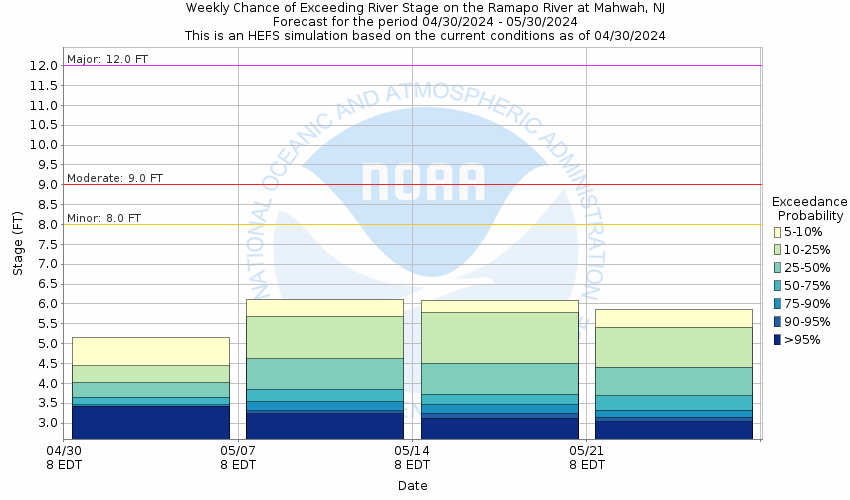
Potential River Levels - Used to
Potential River Levels
Used to Estimate the Chance of Flooding and the Range of Possible River Levels
10 Day (HEFS) 7 Day (NAEFS) 7 Day (GEFS)
HEFS Ensemble NAEFS Ensemble  GEFS Ensemble 

Note: Use the official hydrograph at the top of this web page for river levels within the next 48 hours.

See the Product Description Document link for more details on the interpretation of the 3,7 day graphics. 

Click individual graphics to enlarge.

Forecasts for the Ramapo River at Mahwah are issued as needed during times of high water, and are routinely available.
Collaborative Agencies Collapse
The National Weather Service prepares its forecasts and other services in collaboration with agencies like the US Geological Survey, US Bureau of Reclamation, US Army Corps of Engineers, Natural Resource Conservation Service, National Park Service, ALERT Users Group, Bureau of Indian Affairs, and many state and local emergency managers across the country. For details, please click here.
NWS Information
National Weather Service
Upton Weather Forecast Office
175 Brookhaven Ave. Bldg. NWS-1
Upton, NY 11973
Ask Questions/Webmaster
Page last modified: 2-Nov-2020 7:30 PM
Disclaimer
Credits
Glossary
Privacy Policy
About Us
Career Opportunities