Skip Navigation Link weather.gov  
NOAA logo - Click to go to the NOAA homepage National Weather Service NWS logo - Click to go to the NWS homepage
Advanced Hydrologic Prediction Service
Image background of Navigation bar Left
Navigation Bar End Cap


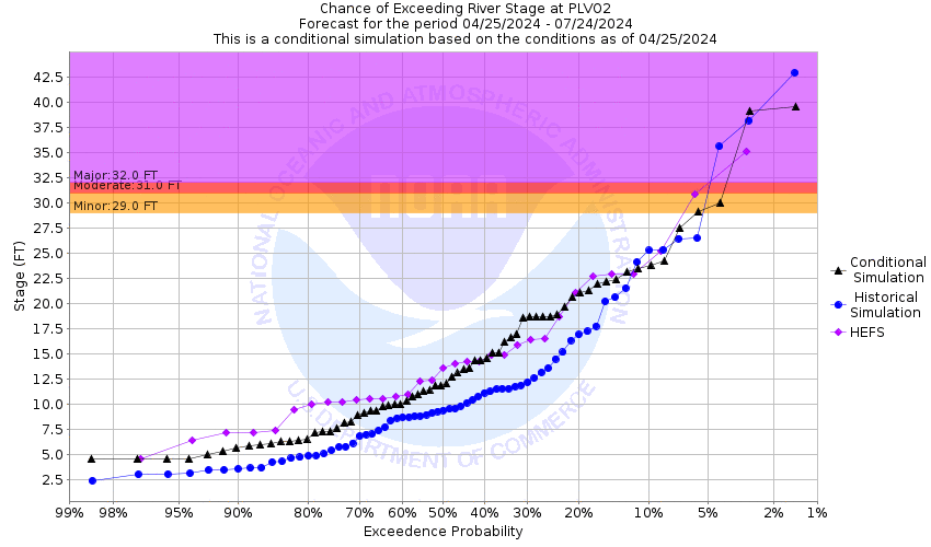
This probabilistic forecast is issued by the Arkansas Red-Basin River Forecast Center.
tab left off Hydrograph tab right off tab left off River at a Glance tab right off tab left off Download tab right off tab left on tab right on
About this graph
Forecasts for the Washita River near Pauls Valley are issued routinely year-round.

Vertical Datum updated from NGVD29 to NAVD88 by gauge owner.

Return to Area Map

Upstream Gauge - at Lindsay Upstream Gauge Downstream Gauge Downstream Gauge - near Dickson
Zoom Level:16
Flood Categories (in feet)
Major Flood Stage: 32
Moderate Flood Stage: 31
Flood Stage: 29
Action Stage: 27
Low Stage (in feet): -9999

Historic Crests
(1) 34.88 ft on 05/11/1950
(2) 34.70 ft on 10/01/1945
(3) 34.15 ft on 10/31/1941
(4) 34.15 ft on 10/31/1941
(5) 33.72 ft on 05/29/1987
(6) 33.42 ft on 05/22/1949
(7) 33.07 ft on 06/10/1941
(8) 33.04 ft on 05/19/1947
(9) 32.75 ft on 05/11/1943
(10) 32.52 ft on 05/25/1947
Show More Historic Crests

(P): Preliminary values subject to further review.

Recent Crests
(1) 24.77 ft on 06/12/2016
(2) 26.63 ft on 05/26/2015
(3) 20.99 ft on 04/11/2008
(4) 25.53 ft on 08/23/2007
(5) 33.72 ft on 05/29/1987
Show More Recent Crests

(P): Preliminary values subject to further review.

Low Water Records
Currently none available.
KML Image
Gauge LocationGauge Map Marker
Disclaimer
Latitude/Longitude Disclaimer: The gauge location shown in the above map is the approximate location based on the latitude/longitude coordinates provided to the NWS by the gauge owner.
Flood Impacts & Photos Collapse
If you notice any errors in the below information, please contact our Webmaster
37 The city of Pauls Valley suffers inundation of about 90 percent... about a thousand acres... in its central business and residential areas... some accessible only by boat. U.S. Highway 77 northwest of town is closed. more than thirteen thousand acres in Garvin County are affected by varied depths up to 8 feet. Flooding of rural lands near Maysville... in western Garvin County... begins hours before the crest reaches Pauls Valley.
36 The city of Pauls Valley suffers inundation of about 90 percent... about a thousand acres... in its central business and residential areas... some accessible only by boat. U.S. Highway 77 northwest of town is closed. About thirteen thousand acres in Garvin County upstream from Pauls Valley are affected by varied depths up to 7 feet. Flooding of rural lands near Maysville in western Garvin County... begins hours before the crest reaches Pauls Valley.
35 The city of Pauls Valley suffers inundation of about 90 percent... About a thousand acres... in its central business and residential areas... some accessible only by boat. U.S. Highway 77 northwest of town is closed. About thirteen thousand acres in Garvin County upstream from Pauls Valley are affected by varied depths up to 6 feet. Flooding of rural lands near Maysville in western Garvin County... begins hours before the crest reaches Pauls Valley.
34 The city of Pauls Valley suffers inundation of about 90 percent... About a thousand acres... in its central business and residential areas... some accessible only by boat. Upstream from Pauls Valley in Garvin County... more than twelve thousand acres of rural lands are affected by varied depths up to 5 feet. Flooding of rural lands near Maysville in western Garvin County... begins hours before the crest reaches Pauls Valley.
33 The city of Pauls Valley suffers inundation of the majority in its central business and residential areas. some accessible only by boat. Upstream from Pauls Valley in Garvin County... about eleven thousand acres of farmlands are affected by varied depths up to 4 feet. Flooding of rural lands near Maysville in western Garvin County... begins hours before the crest reaches Pauls Valley.
32 In Pauls Valley... expect wide spread flooding in the old central business and residential districts. many buildings not flooded are isolated by water in the streets. About ten thousand acres of agricultural lands in Garvin County upstream from Pauls Valley are affected by varied depths up to 3 feet. Rural flooding near Maysville in western Garvin County begins several hours before Pauls Valley. No other towns are threatened by the main river.
31 In Pauls Valley... shallow flooding occurs across much of the old central business district. many buildings not flooded may be cut off by water in streets. Upstream from Pauls Valley in Garvin County... more than eight thousand acres are affected by varied depths depths two or more feet. Flooding of rural lands near Maysville... in western Garvin County... begins hours before Pauls Valley.
30 In Pauls Valley... portions of the central residential district may be isolated by water in streets. in Garvin County... farmlands... rural roads... and oilfields may see varied depths averaging about a foot. Locations not actually flooded may be inaccesible for a day or more. Overflows commence in western portions of the county several hours before Pauls Valley. Maysville and other towns are not threatened by the main river.
29 In Garvin County... agricultural lands... rural roads... and oilfields may see varied flood depths up to 2 feet. locations not actually flooded may be cut off from access for a day or more. Flooding commences in western portions of Garvin County several hours before Pauls Valley. Maysville and other towns are not threatened by the main river.
28 Expect near bankfull flows along the valley in Garvin County except at locations where tributary streams may be flooding as they empty into the river.
27 Expect near bankfull or lower flows along the valley in Garvin County except at locations where tributary streams may be flooding as they empty into the river.

Other Real-time and/or Archive Data Sources:

Collaborative Agencies Collapse
The National Weather Service prepares its forecasts and other services in collaboration with agencies like the US Geological Survey, US Bureau of Reclamation, US Army Corps of Engineers, Natural Resource Conservation Service, National Park Service, ALERT Users Group, Bureau of Indian Affairs, and many state and local emergency managers across the country. For details, please click here.
NWS Information
National Weather Service
Norman Weather Forecast Office
National Weather Center
120 David L. Boren Blvd.
Suite 2400
Norman, OK 73072
(405) 325-3816
Ask Questions/Webmaster
Page last modified: 2-Nov-2020 7:29 PM
Disclaimer
Credits
Glossary
Privacy Policy
About Us
Career Opportunities